Using Satellites to Monitor and Observe Sea Surface Temperatures
Special Stories
11 Jun 2018 7:34 AM
From NOAA
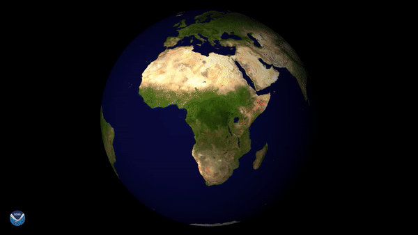
Satellites are a valuable tool for monitoring Earth’s oceans, which cover more than 70 percent of our planet. This visualization shows 2017 sea surface temperatures in the North Atlantic Ocean, the Gulf of Mexico, and the Caribbean using data from NOAA’s satellites.
Sea surface temperatures measured by satellites tell us how warm or cold the top millimeter of the ocean surface is. Knowing the temperature of the ocean surface helps scientists predict seasonal weather patterns and long-term climate outlooks, including the number of hurricanes and tropical storms we can expect in a given year, and the likelihood that large-scale climate patterns such as El Niño and La Niña will develop.
 Sea surface temperatures warm and cool throughout the year, responding to seasonal changes in the amount of energy from the sun that reaches Earth’s northern or southern hemisphere. In this visualization, we see that temperatures bottom out in February and are warmest in late August and early September, which is also when tropical cyclone activity typically peaks each year.
Warmer sea surface temperatures help transport more heat energy and moisture into the atmosphere. When those temperatures reach at least 80 degrees Fahrenheit (27°C) and other atmospheric conditions are favorable, hurricanes and tropical storms are more likely to form.
Sea surface temperatures warm and cool throughout the year, responding to seasonal changes in the amount of energy from the sun that reaches Earth’s northern or southern hemisphere. In this visualization, we see that temperatures bottom out in February and are warmest in late August and early September, which is also when tropical cyclone activity typically peaks each year.
Warmer sea surface temperatures help transport more heat energy and moisture into the atmosphere. When those temperatures reach at least 80 degrees Fahrenheit (27°C) and other atmospheric conditions are favorable, hurricanes and tropical storms are more likely to form.
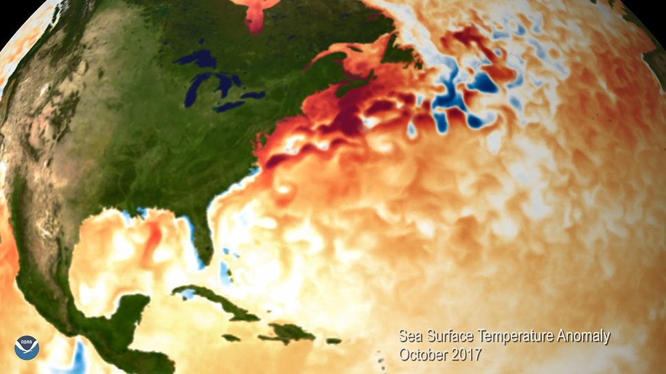 The second half of this visualization shows a monthly replay of 2017 sea surface temperature anomalies, which indicate how much warmer or colder the ocean surface was compared to normal. The darker the color, the greater the difference from the long-term average. Lighter shades and white areas show conditions closer to the 30-year (1981-2010) average.
While the anomaly patterns are constantly changing, we generally see far more red and orange shades during each month of 2017 - especially near the U.S. East Coast. Persistently warmer than normal sea surface temperatures in the Atlantic Ocean and Gulf of Mexico was one factor behind the severe 2017 Atlantic hurricane season - and fits a pattern of warmer-than-average ocean temperatures across much of the globe.
The second half of this visualization shows a monthly replay of 2017 sea surface temperature anomalies, which indicate how much warmer or colder the ocean surface was compared to normal. The darker the color, the greater the difference from the long-term average. Lighter shades and white areas show conditions closer to the 30-year (1981-2010) average.
While the anomaly patterns are constantly changing, we generally see far more red and orange shades during each month of 2017 - especially near the U.S. East Coast. Persistently warmer than normal sea surface temperatures in the Atlantic Ocean and Gulf of Mexico was one factor behind the severe 2017 Atlantic hurricane season - and fits a pattern of warmer-than-average ocean temperatures across much of the globe.
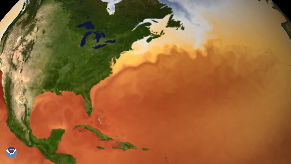 The Gulf Stream meanders around Florida and flows past the U.S. East Coast and Canada before heading north and eastward toward Europe. The temperature contrast along the edge of the Gulf Stream can increase the intensity of both tropical and extratropical cyclonesmoving up the coast. For example, the warm waters of the Gulf Stream help strengthen mid-latitude storm systems, such as the powerful nor’easters that sometimes produce heavy snow across the Eastern Seaboard during the winter months.
While the speed and intensity of the Gulf Stream change throughout the year, the current is a relative constant, even as sea surface temperatures in other parts of the Atlantic Basin show a more irregular pattern from month to month.
Edited for WeatherNation by Meteorologist Mace Michaels
The Gulf Stream meanders around Florida and flows past the U.S. East Coast and Canada before heading north and eastward toward Europe. The temperature contrast along the edge of the Gulf Stream can increase the intensity of both tropical and extratropical cyclonesmoving up the coast. For example, the warm waters of the Gulf Stream help strengthen mid-latitude storm systems, such as the powerful nor’easters that sometimes produce heavy snow across the Eastern Seaboard during the winter months.
While the speed and intensity of the Gulf Stream change throughout the year, the current is a relative constant, even as sea surface temperatures in other parts of the Atlantic Basin show a more irregular pattern from month to month.
Edited for WeatherNation by Meteorologist Mace Michaels
Sea surface temperatures warm and cool throughout the year, responding to seasonal changes in the amount of energy from the sun that reaches Earth’s northern or southern hemisphere. In this visualization, we see that temperatures bottom out in February and are warmest in late August and early September, which is also when tropical cyclone activity typically peaks each year.
Warmer sea surface temperatures help transport more heat energy and moisture into the atmosphere. When those temperatures reach at least 80 degrees Fahrenheit (27°C) and other atmospheric conditions are favorable, hurricanes and tropical storms are more likely to form.
Mapping sea surface temperature anomalies
The second half of this visualization shows a monthly replay of 2017 sea surface temperature anomalies, which indicate how much warmer or colder the ocean surface was compared to normal. The darker the color, the greater the difference from the long-term average. Lighter shades and white areas show conditions closer to the 30-year (1981-2010) average.
While the anomaly patterns are constantly changing, we generally see far more red and orange shades during each month of 2017 - especially near the U.S. East Coast. Persistently warmer than normal sea surface temperatures in the Atlantic Ocean and Gulf of Mexico was one factor behind the severe 2017 Atlantic hurricane season - and fits a pattern of warmer-than-average ocean temperatures across much of the globe.
The Gulf Stream in motion
One notable feature of this animation is the Gulf Stream- a fast-moving current of warm water in the North Atlantic that influences the climate of eastern North America and western Europe. Originating in the Gulf of Mexico, the current moves at a speed of about 4 miles per hour and transports nearly four billion cubic feet of water per second - an amount greater than that carried by all of the world's rivers combined.
The Gulf Stream meanders around Florida and flows past the U.S. East Coast and Canada before heading north and eastward toward Europe. The temperature contrast along the edge of the Gulf Stream can increase the intensity of both tropical and extratropical cyclonesmoving up the coast. For example, the warm waters of the Gulf Stream help strengthen mid-latitude storm systems, such as the powerful nor’easters that sometimes produce heavy snow across the Eastern Seaboard during the winter months.
While the speed and intensity of the Gulf Stream change throughout the year, the current is a relative constant, even as sea surface temperatures in other parts of the Atlantic Basin show a more irregular pattern from month to month.
Edited for WeatherNation by Meteorologist Mace MichaelsAll Weather News
More
Wildfire Outbreak in the Pacific Northwest
SPOKANE, WA - On Saturday, August 1st, the Ol
3 Aug 2026 1:55 AM

More Storms for the East Through Monday
A low-pressure system that moved through the
3 Aug 2026 1:50 AM


After Reaching Category 5, Genevieve Weakens in the Pacific
PacificGenevieve formed last Friday south of
3 Aug 2026 12:30 AM

Flooding, Severe Storms Target the Midwest Again
After an active week of storms across the nor
1 Aug 2026 1:40 AM

Flooding Risk Increases as Heavy Rain Targets the Tri-State Area
Tuesday, heavy rainfall moved across the Nort
30 Jul 2026 12:25 AM

Severe Weather: Energy From the Midwest Now in the Southeast
UPPER MIDWEST - Through Monday, dangerous tor
29 Jul 2026 10:30 PM