Weather Forecast Model Predicts Complex Patterns of Volcanic Ash Dispersal
Special Stories
3 May 2018 7:42 AM
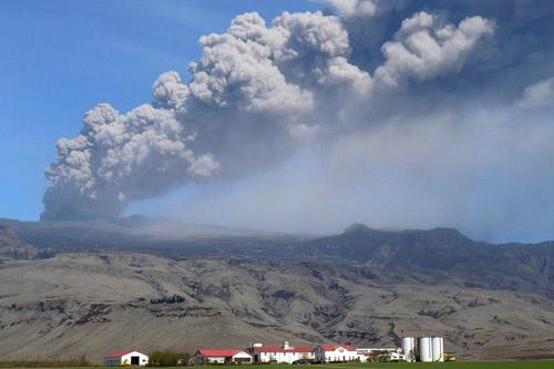
[The 2010 eruption of Eyjafjallajkull, Iceland. Credit Susanna Jenkins]
From University of Bristol
New research, led by the University of Bristol, has provided fresh insight into how huge volcanic ash plumes, which can critically disrupt aviation and cause major impact on the ground, are transported in the atmosphere.
n 2010, the eruption of the Icelandic volcano Eyjafjallajӧkull caused widespread travel chaos, with the cancellation of more than 100,000 flights and economic losses of $200 million per day.
By using high-resolution meteorological modelling of volcanic eruptions on the Caribbean island of St Vincent, the research, published in the journal Scientific Reports, aims to improve how we respond to explosive volcanic eruptions, and better forecast volcanic ash dispersal.
An international team of researchers from institutions including the Universities of Bristol, East Anglia, Oxford, Kyoto, Earth Observatory Singapore and the West Indies has shown how it is the interaction of the dynamics of the atmosphere with volcanic plumes that produces the complex patterns of ash transport which threaten aviation and cause impacts on the ground.
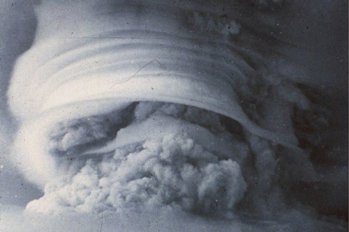 [The eruption of Soufrière St Vincent, 1979, showing the volcanic plume interacting with atmospheric moisture. Credit: Steve Sparks]
The team used a combination of high-resolution meteorological modelling, archives of historical observations of eruptions, and field measurements of ash deposits, to reconstruct two eruptions of Soufrière St Vincent, an island volcano in the Caribbean.
The island topography, steady trade wind patterns, and very detailed archives of historical eyewitness accounts and field measurements for eruptions in 1902 and 1979 made St Vincent an ideal location for the study.
Using high-resolution simulations of the atmospheric conditions, the team identified how the wind flow around the volcano topography controls ash deposit patterns around the volcano on the island, and surprisingly, at much greater distances.
First author and atmospheric modeller Alex Poulidis (Kyoto University) says “The volcano shape affects the wind patterns and atmospheric conditions, influencing ash deposition over hundreds of km from St Vincent, including on the island of Barbados, 180 km away”. Poulidis’ simulations reproduced ash deposit thicknesses, and ash cloud arrival times, on St Vincent for the smaller 1979 eruption, and at a range of locations including other Caribbean islands and ships up to 1700 km away for the much larger 1902 eruption.
[The eruption of Soufrière St Vincent, 1979, showing the volcanic plume interacting with atmospheric moisture. Credit: Steve Sparks]
The team used a combination of high-resolution meteorological modelling, archives of historical observations of eruptions, and field measurements of ash deposits, to reconstruct two eruptions of Soufrière St Vincent, an island volcano in the Caribbean.
The island topography, steady trade wind patterns, and very detailed archives of historical eyewitness accounts and field measurements for eruptions in 1902 and 1979 made St Vincent an ideal location for the study.
Using high-resolution simulations of the atmospheric conditions, the team identified how the wind flow around the volcano topography controls ash deposit patterns around the volcano on the island, and surprisingly, at much greater distances.
First author and atmospheric modeller Alex Poulidis (Kyoto University) says “The volcano shape affects the wind patterns and atmospheric conditions, influencing ash deposition over hundreds of km from St Vincent, including on the island of Barbados, 180 km away”. Poulidis’ simulations reproduced ash deposit thicknesses, and ash cloud arrival times, on St Vincent for the smaller 1979 eruption, and at a range of locations including other Caribbean islands and ships up to 1700 km away for the much larger 1902 eruption.
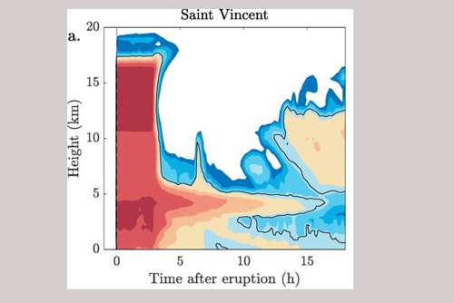 [Simulation results showing long-lasting peak in ash concentration (red and orange colours) around 5 km height in the atmosphere, at the flight level of commercial aircraft. From University of Bristol]
The simulations also show how wind patterns can trap ash in layers in the atmosphere, similar to those observed for the Icelandic volcano Eyjafjallajӧkull, at concentrations sufficient to be a threat for aviation. These layers act as sources of ash which are then dispersed along different atmospheric pathways.
Recent reanalysis of volcanic ash deposits following the Eyjafjallajӧkull eruption has shown that ash deposits often have unexpected peaks in thickness far from the volcano. The team’s modelling results show that the combination of different atmospheric layer sources, and the range of particle sizes of the ash, can reproduce the peaks in ash deposit thickness measured for the 1902 eruption of St Vincent.
The study lead, volcanologist Dr Jeremy Phillips from the University of Bristol’s School of Earth Sciences, said: “Taken as a whole, the results show that the combination of the atmosphere and eruption lead to complex ash transport patterns.
[Simulation results showing long-lasting peak in ash concentration (red and orange colours) around 5 km height in the atmosphere, at the flight level of commercial aircraft. From University of Bristol]
The simulations also show how wind patterns can trap ash in layers in the atmosphere, similar to those observed for the Icelandic volcano Eyjafjallajӧkull, at concentrations sufficient to be a threat for aviation. These layers act as sources of ash which are then dispersed along different atmospheric pathways.
Recent reanalysis of volcanic ash deposits following the Eyjafjallajӧkull eruption has shown that ash deposits often have unexpected peaks in thickness far from the volcano. The team’s modelling results show that the combination of different atmospheric layer sources, and the range of particle sizes of the ash, can reproduce the peaks in ash deposit thickness measured for the 1902 eruption of St Vincent.
The study lead, volcanologist Dr Jeremy Phillips from the University of Bristol’s School of Earth Sciences, said: “Taken as a whole, the results show that the combination of the atmosphere and eruption lead to complex ash transport patterns.
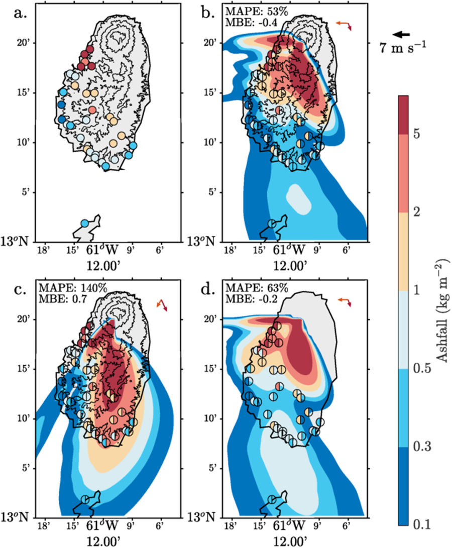 [Ash fall distributions following the April 26, 1979 eruption of Soufriere St Vincent. (a) Observed, (b–d) simulated from the meteorological-ash-dispersion model, where the experiments are (b) Control; (c) Alternative Wind profile (lower shear); and (d) Flat Topography. Observations are plotted over the contours using filled circles markers. In Panels b–d observations correspond to the left half of the marker and modelled values to the right. Topographic contours are shown at 100 m and every 300 m after that. Domain-averaged wind vectors at 100 m (orange) and averaged between 6–12 km (dark red) are shown in the top right corner. Plotted using MATLAB Release 2016b, The MathWorks, Inc., Natick, Massachusetts, United States.]
“Being able to reproduce these with meteorological models advances our capability to react to volcanic eruptions, and to forecast airborne and ground level ash concentrations during eruptions.”
Co-author Prof Jenni Barclay (University of East Anglia) added “We initiated this study because the memories of the local population of the style and intensity of the ash impacts clearly varied as a function of more than just distance from the volcano. We also had incredibly detailed historical observations from 1902 to compare with our results. It's a fantastic example of integrating different areas of research to improve overall understanding”.
Co-author Prof Richard Robertson of The University of the West Indies Seismic Research Centre observed that "This study focuses attention on the poorly-defined threat posed by volcanic ash in the Caribbean region and shows how an eruption from a single volcano can have regional impacts that would be significant for aviation and agriculture".
Edited for WeatherNation by Meteorologist Mace Michaels
[Ash fall distributions following the April 26, 1979 eruption of Soufriere St Vincent. (a) Observed, (b–d) simulated from the meteorological-ash-dispersion model, where the experiments are (b) Control; (c) Alternative Wind profile (lower shear); and (d) Flat Topography. Observations are plotted over the contours using filled circles markers. In Panels b–d observations correspond to the left half of the marker and modelled values to the right. Topographic contours are shown at 100 m and every 300 m after that. Domain-averaged wind vectors at 100 m (orange) and averaged between 6–12 km (dark red) are shown in the top right corner. Plotted using MATLAB Release 2016b, The MathWorks, Inc., Natick, Massachusetts, United States.]
“Being able to reproduce these with meteorological models advances our capability to react to volcanic eruptions, and to forecast airborne and ground level ash concentrations during eruptions.”
Co-author Prof Jenni Barclay (University of East Anglia) added “We initiated this study because the memories of the local population of the style and intensity of the ash impacts clearly varied as a function of more than just distance from the volcano. We also had incredibly detailed historical observations from 1902 to compare with our results. It's a fantastic example of integrating different areas of research to improve overall understanding”.
Co-author Prof Richard Robertson of The University of the West Indies Seismic Research Centre observed that "This study focuses attention on the poorly-defined threat posed by volcanic ash in the Caribbean region and shows how an eruption from a single volcano can have regional impacts that would be significant for aviation and agriculture".
Edited for WeatherNation by Meteorologist Mace Michaels
[The eruption of Soufrière St Vincent, 1979, showing the volcanic plume interacting with atmospheric moisture. Credit: Steve Sparks]
The team used a combination of high-resolution meteorological modelling, archives of historical observations of eruptions, and field measurements of ash deposits, to reconstruct two eruptions of Soufrière St Vincent, an island volcano in the Caribbean.
The island topography, steady trade wind patterns, and very detailed archives of historical eyewitness accounts and field measurements for eruptions in 1902 and 1979 made St Vincent an ideal location for the study.
Using high-resolution simulations of the atmospheric conditions, the team identified how the wind flow around the volcano topography controls ash deposit patterns around the volcano on the island, and surprisingly, at much greater distances.
First author and atmospheric modeller Alex Poulidis (Kyoto University) says “The volcano shape affects the wind patterns and atmospheric conditions, influencing ash deposition over hundreds of km from St Vincent, including on the island of Barbados, 180 km away”. Poulidis’ simulations reproduced ash deposit thicknesses, and ash cloud arrival times, on St Vincent for the smaller 1979 eruption, and at a range of locations including other Caribbean islands and ships up to 1700 km away for the much larger 1902 eruption.
[Simulation results showing long-lasting peak in ash concentration (red and orange colours) around 5 km height in the atmosphere, at the flight level of commercial aircraft. From University of Bristol]
The simulations also show how wind patterns can trap ash in layers in the atmosphere, similar to those observed for the Icelandic volcano Eyjafjallajӧkull, at concentrations sufficient to be a threat for aviation. These layers act as sources of ash which are then dispersed along different atmospheric pathways.
Recent reanalysis of volcanic ash deposits following the Eyjafjallajӧkull eruption has shown that ash deposits often have unexpected peaks in thickness far from the volcano. The team’s modelling results show that the combination of different atmospheric layer sources, and the range of particle sizes of the ash, can reproduce the peaks in ash deposit thickness measured for the 1902 eruption of St Vincent.
The study lead, volcanologist Dr Jeremy Phillips from the University of Bristol’s School of Earth Sciences, said: “Taken as a whole, the results show that the combination of the atmosphere and eruption lead to complex ash transport patterns.
[Ash fall distributions following the April 26, 1979 eruption of Soufriere St Vincent. (a) Observed, (b–d) simulated from the meteorological-ash-dispersion model, where the experiments are (b) Control; (c) Alternative Wind profile (lower shear); and (d) Flat Topography. Observations are plotted over the contours using filled circles markers. In Panels b–d observations correspond to the left half of the marker and modelled values to the right. Topographic contours are shown at 100 m and every 300 m after that. Domain-averaged wind vectors at 100 m (orange) and averaged between 6–12 km (dark red) are shown in the top right corner. Plotted using MATLAB Release 2016b, The MathWorks, Inc., Natick, Massachusetts, United States.]
“Being able to reproduce these with meteorological models advances our capability to react to volcanic eruptions, and to forecast airborne and ground level ash concentrations during eruptions.”
Co-author Prof Jenni Barclay (University of East Anglia) added “We initiated this study because the memories of the local population of the style and intensity of the ash impacts clearly varied as a function of more than just distance from the volcano. We also had incredibly detailed historical observations from 1902 to compare with our results. It's a fantastic example of integrating different areas of research to improve overall understanding”.
Co-author Prof Richard Robertson of The University of the West Indies Seismic Research Centre observed that "This study focuses attention on the poorly-defined threat posed by volcanic ash in the Caribbean region and shows how an eruption from a single volcano can have regional impacts that would be significant for aviation and agriculture".
Edited for WeatherNation by Meteorologist Mace MichaelsAll Weather News
More
Fronts Continue To Spark Severe Weather Across the Plains
A cold front that brought record lows to the
18 Jul 2025 10:40 PM

Extreme Heat Impacts for the East Coast & South
Extreme heat continues to impact several area
18 Jul 2025 10:05 PM

Flooding Threat Remains Elevated in the East
A cold front pushing through the Eastern Seab
18 Jul 2025 9:10 PM

EF-2 Firenado from the Deer Creek Fire in Utah
A fire tornado was spotted near La Sal, Utah
18 Jul 2025 7:30 AM

Tropical System Brings Flood Risk to the Central Gulf
Time has run out for notable tropical develop
18 Jul 2025 3:05 AM

Heavy Rain, Flooding Threat Returns to Florida
Keep the rain boots handy in Florida - heavy
13 Jul 2025 12:50 PM

Severe Storm Risk Pushes into the Great Lakes, Ohio Valley
Friday was another busy day with severe weath
12 Jul 2025 8:00 PM