Your Weekend Travel Forecast
Top Stories
30 Mar 2018 9:31 PM
It's time for the holiday weekend and we have the spots to watch for weather-related impacts when traveling. Here's a look at the bigger picture of forecast precipitation, both rain and snow in green and blues respectively, from early Saturday morning through Monday evening (31st to 2nd).
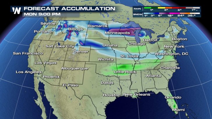 Forecast precipitation through Monday evening, April 2.
The snowiest spots will be to the north, closer to the Canadian border as a strong low pressure system brings a quick, yet heavy blast of snow on Saturday the 31st. This will mainly impact the Upper Midwest with low visibility and then very cold air by Easter Sunday morning. Another low exiting the Rockies Saturday afternoon will drift southeast through Nebraska, Missouri, and the Ohio Valley Sunday morning through Sunday night. That has the potential of a quick (relatively light) hit of snow! Thus to the north, watch and be mindful of slippery roads due to snow and wind, also colder air. To the south a few rain showers are possible during the weekend for parts of Oklahoma, Arkansas, and Tennessee, as well as South Florida.
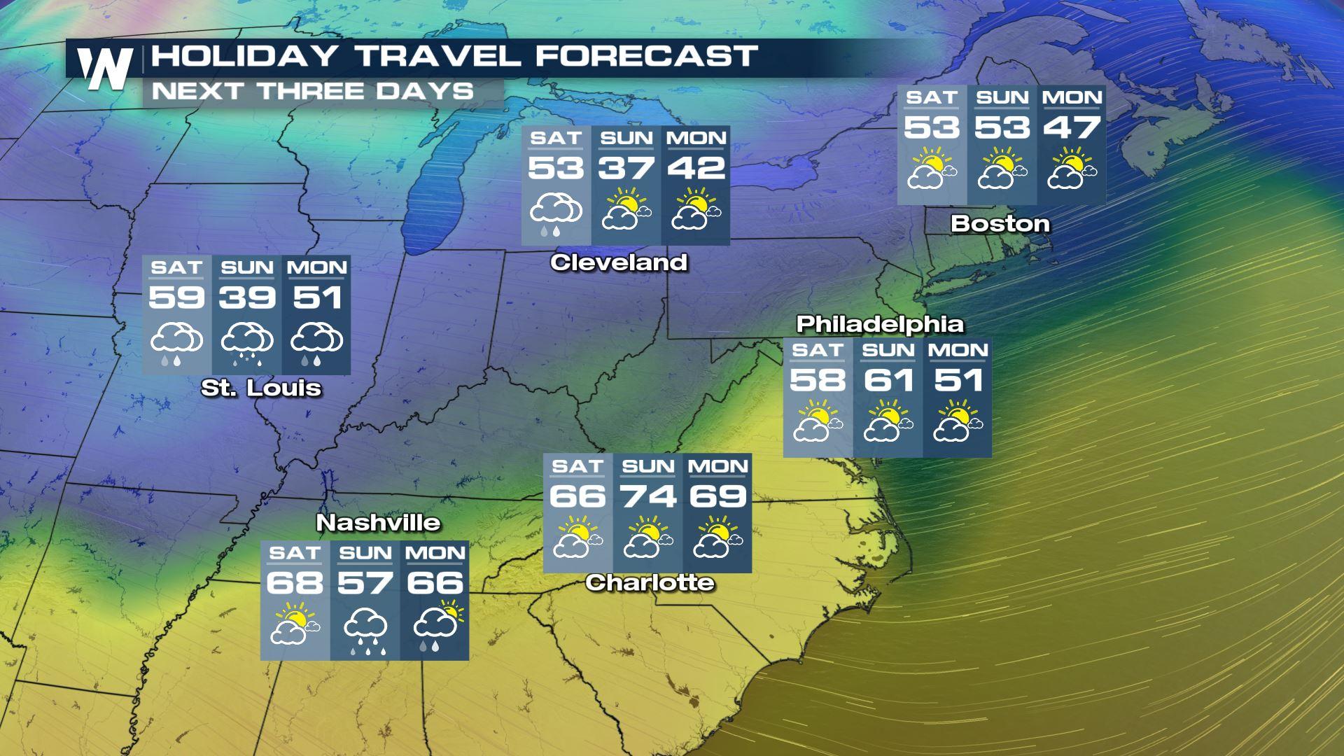
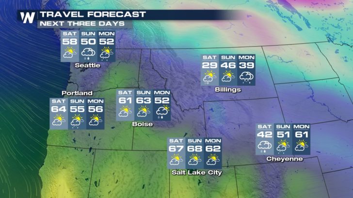
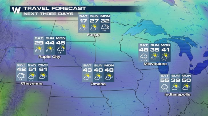
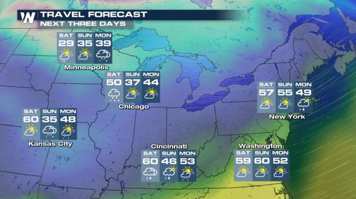
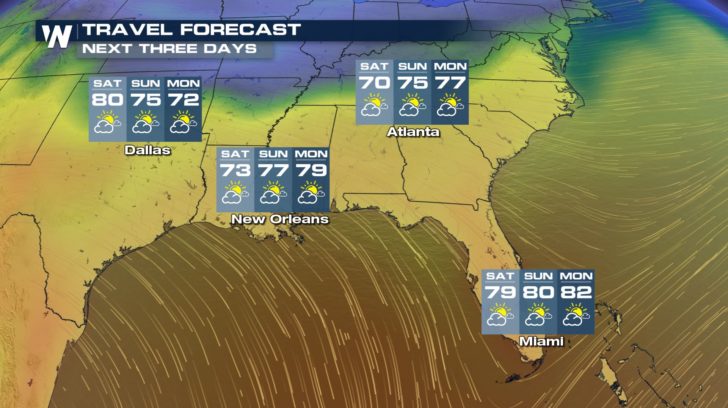
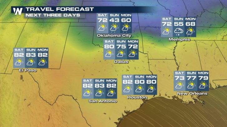
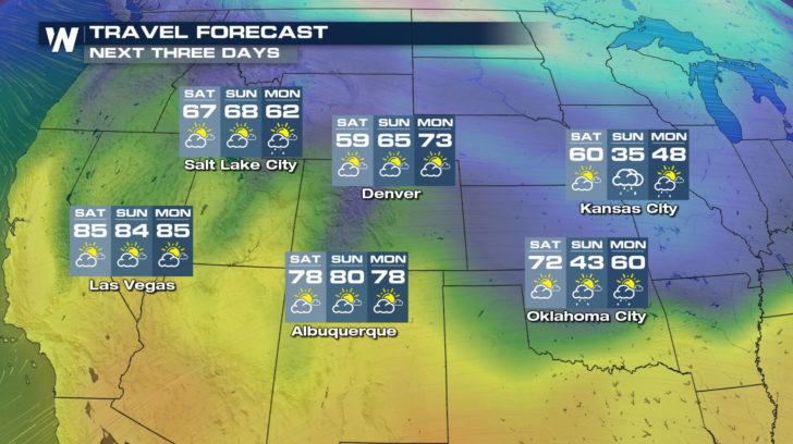
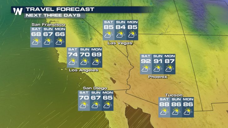
Now we are going to take a look at the region-by-region forecast for the next few days for select cities. We'll go to cities along the northern tier of the country that will find wetter weather, then down to the drier locations to the south. Take a look below to find your expected high temperature and sky condition!
Forecast precipitation through Monday evening, April 2.
The snowiest spots will be to the north, closer to the Canadian border as a strong low pressure system brings a quick, yet heavy blast of snow on Saturday the 31st. This will mainly impact the Upper Midwest with low visibility and then very cold air by Easter Sunday morning. Another low exiting the Rockies Saturday afternoon will drift southeast through Nebraska, Missouri, and the Ohio Valley Sunday morning through Sunday night. That has the potential of a quick (relatively light) hit of snow! Thus to the north, watch and be mindful of slippery roads due to snow and wind, also colder air. To the south a few rain showers are possible during the weekend for parts of Oklahoma, Arkansas, and Tennessee, as well as South Florida.
Now we are going to take a look at the region-by-region forecast for the next few days for select cities. We'll go to cities along the northern tier of the country that will find wetter weather, then down to the drier locations to the south. Take a look below to find your expected high temperature and sky condition!

 You can stay up to date with the expected weather via our WeatherNation app, here on WeatherNationTV.com and on-air as we cover the top stories impacting you the most. Have a safe and enjoyable weekend.
For WeatherNation, Meteorologist Steve Glazier
You can stay up to date with the expected weather via our WeatherNation app, here on WeatherNationTV.com and on-air as we cover the top stories impacting you the most. Have a safe and enjoyable weekend.
For WeatherNation, Meteorologist Steve Glazier
Forecast precipitation through Monday evening, April 2.
The snowiest spots will be to the north, closer to the Canadian border as a strong low pressure system brings a quick, yet heavy blast of snow on Saturday the 31st. This will mainly impact the Upper Midwest with low visibility and then very cold air by Easter Sunday morning. Another low exiting the Rockies Saturday afternoon will drift southeast through Nebraska, Missouri, and the Ohio Valley Sunday morning through Sunday night. That has the potential of a quick (relatively light) hit of snow! Thus to the north, watch and be mindful of slippery roads due to snow and wind, also colder air. To the south a few rain showers are possible during the weekend for parts of Oklahoma, Arkansas, and Tennessee, as well as South Florida.
Now we are going to take a look at the region-by-region forecast for the next few days for select cities. We'll go to cities along the northern tier of the country that will find wetter weather, then down to the drier locations to the south. Take a look below to find your expected high temperature and sky condition!
You can stay up to date with the expected weather via our WeatherNation app, here on WeatherNationTV.com and on-air as we cover the top stories impacting you the most. Have a safe and enjoyable weekend.
For WeatherNation, Meteorologist Steve GlazierAll Weather News
More
Fronts Continue To Spark Severe Weather Across the Plains
A cold front that brought record lows to the
18 Jul 2025 10:40 PM

Extreme Heat Impacts for the East Coast & South
Extreme heat continues to impact several area
18 Jul 2025 10:05 PM

Flooding Threat Remains Elevated in the East
A cold front pushing through the Eastern Seab
18 Jul 2025 9:10 PM

EF-2 Firenado from the Deer Creek Fire in Utah
A fire tornado was spotted near La Sal, Utah
18 Jul 2025 7:30 AM

Tropical System Brings Flood Risk to the Central Gulf
Time has run out for notable tropical develop
18 Jul 2025 3:05 AM

Heavy Rain, Flooding Threat Returns to Florida
Keep the rain boots handy in Florida - heavy
13 Jul 2025 12:50 PM

Severe Storm Risk Pushes into the Great Lakes, Ohio Valley
Friday was another busy day with severe weath
12 Jul 2025 8:00 PM