Wettest Winter on Record For Lower 48
Special Stories
6 Mar 2019 2:45 PM
A NOAA analysis of this winter's precipitation revealed that this winter was the wettest on record for the lower 48.
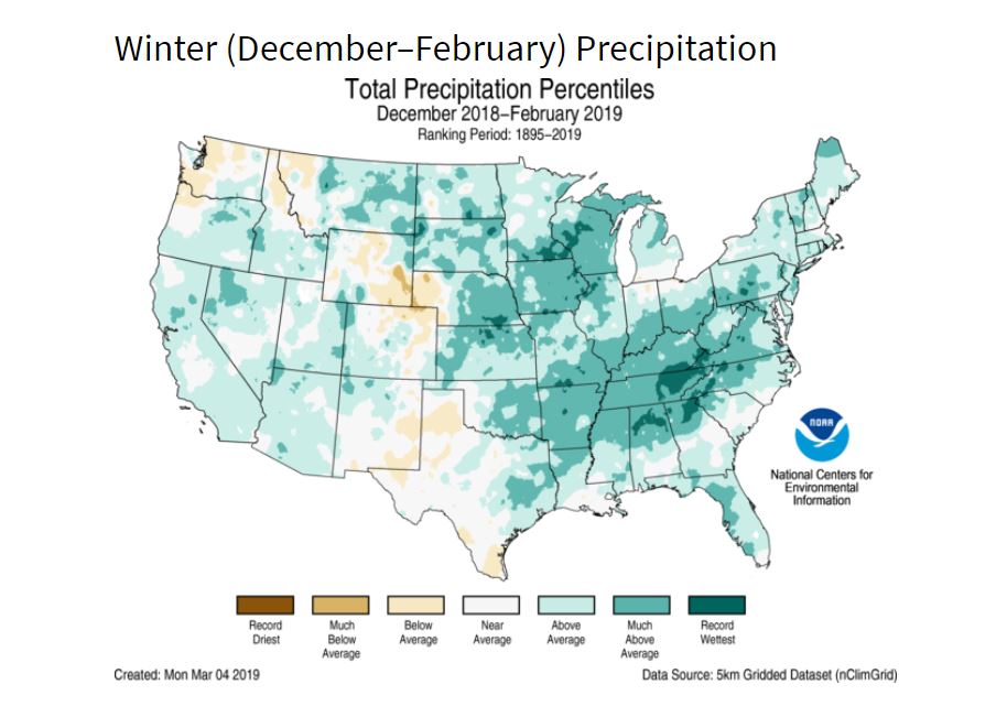
The National Climatic Data Center (NCDC - part of the National Oceanic and Atmospheric Administration, or NOAA) climate look-back determined that December, January and February collectively produced more precipitation than any other meteorological winter. With an average nationwide precipitation total of 3.22", this winter narrowly squeaks by the winter of 1997-98 by 0.02" for the title of wettest winter on record for the lower 48.
It was especially wet - and snowy - in the Midwest and the Southeast. Take a look at this map for a better idea for where the highest precipitation anomalies took place this winter:
 The month of February was a cold one for the lower 48, with the monthly temperature running 1.8° below average. Temperatures were especially cold in the northern Plains states of Nebraska, North and South Dakota and Montana. Much of the western third of the country was abnormally chilly, as well.
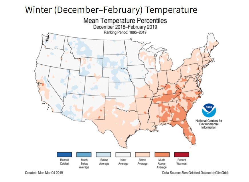 That said, through the winter months of December, January and February, temperatures ran 1.2° above average across the contiguous United States.
For WeatherNation: Meteorologist Chris Bianchi
That said, through the winter months of December, January and February, temperatures ran 1.2° above average across the contiguous United States.
For WeatherNation: Meteorologist Chris Bianchi
The month of February was a cold one for the lower 48, with the monthly temperature running 1.8° below average. Temperatures were especially cold in the northern Plains states of Nebraska, North and South Dakota and Montana. Much of the western third of the country was abnormally chilly, as well.
That said, through the winter months of December, January and February, temperatures ran 1.2° above average across the contiguous United States.
For WeatherNation: Meteorologist Chris BianchiAll Weather News
More
Major River Flooding Causes Damage; Another Day of Storms in New Mexico
A powerful low pressure system has been movin
25 Oct 2026 6:10 PM

Mount Slushmore? Taking a look at Dakota Snow Chances
The cooler weather is finding places to go fi
25 Oct 2026 6:05 PM

Sunny Day Flooding; King Tides Surge This Week
This week, the ocean is coming to low lying a
25 Oct 2026 10:30 AM

Hurricane Vance Swirling in the Pacific
After becoming a hurricane Friday, Vance has
25 Oct 2026 10:20 AM

Warmer Than Average: Above-Normal Temperatures Across the Central U.S. This Week
WHAT TO EXPECTA ridge of high pressure linger
25 Oct 2026 10:15 AM


Several Fires Break Out in SoCal Last Week Amid Santa Ana Wind Event
Santa Ana winds helped several fires grow qui
19 Oct 2026 1:25 PM