What is the Winter Storm Severity Index?
Special Stories
27 Jan 2021 12:05 PM
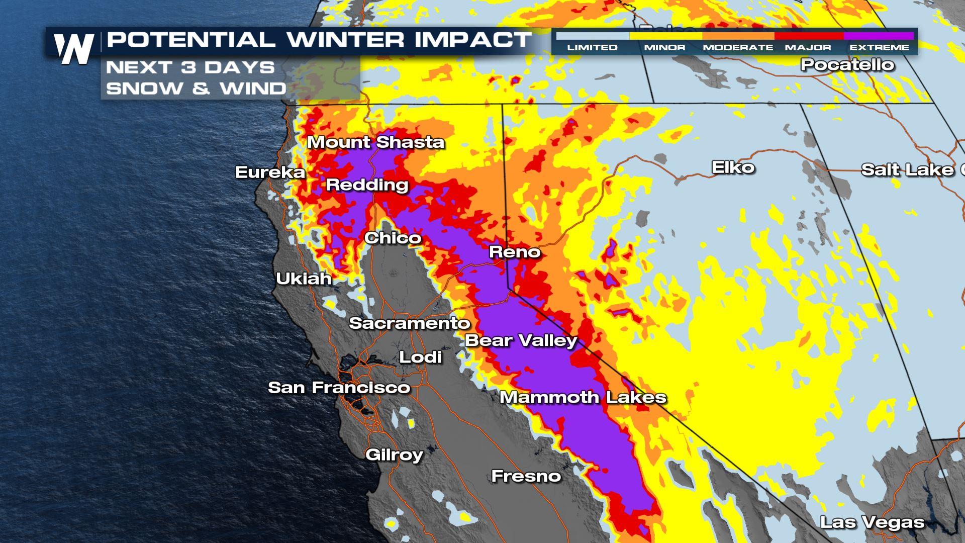
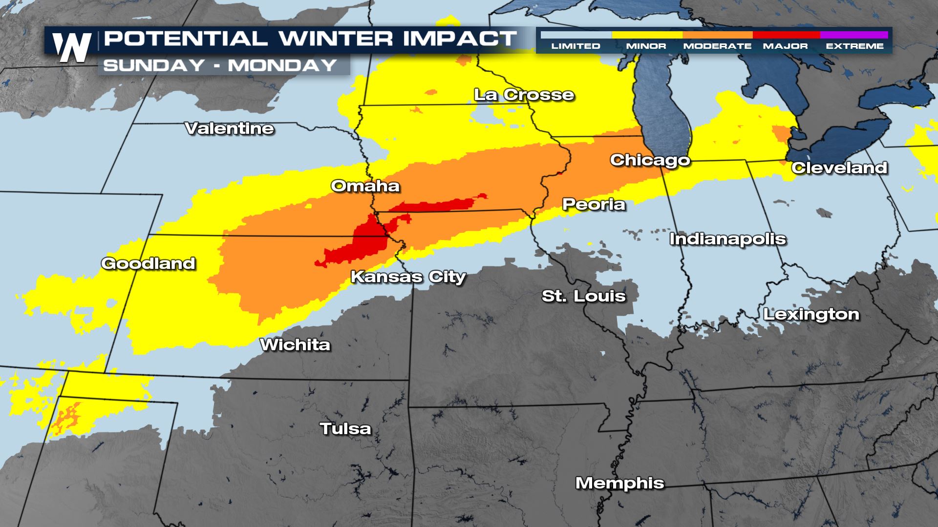
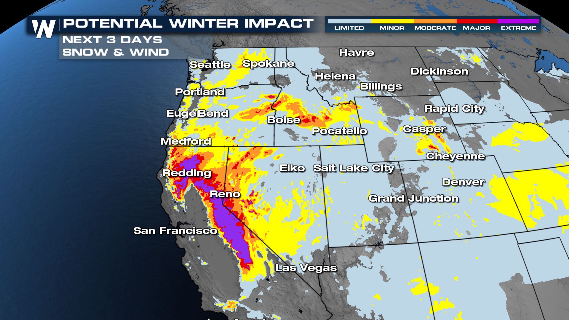
When there are big weather events happening across the country, you might see us show you on WeatherNation a map that looks like this:
 The Winter Storm Severity Index, or WSSI, is put together by NOAA's Weather Prediction Center and it's a new tool for us to use to help make you more aware of how different types of winter weather could impact your day-to-day routine. The information that goes into making these maps is based on what is in the forecast and does not include weather prior to the date (s) specified. It's important to note that this does not show watches, warnings, or advisories but serves as an additional way we can convey the severity of a weather event anywhere from one to three days in advance.
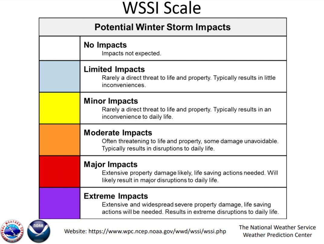
Just like when we talk about levels with severe weather outlooks from the Storm Prediction Center, there are also different levels on the WSSI scale ranging from little to no impact from a winter weather event up to major to extreme impacts where you will need to take action to protect life and property.
The Winter Storm Severity Index, or WSSI, is put together by NOAA's Weather Prediction Center and it's a new tool for us to use to help make you more aware of how different types of winter weather could impact your day-to-day routine. The information that goes into making these maps is based on what is in the forecast and does not include weather prior to the date (s) specified. It's important to note that this does not show watches, warnings, or advisories but serves as an additional way we can convey the severity of a weather event anywhere from one to three days in advance.
Just like when we talk about levels with severe weather outlooks from the Storm Prediction Center, there are also different levels on the WSSI scale ranging from little to no impact from a winter weather event up to major to extreme impacts where you will need to take action to protect life and property.
 There are different components that will highlight the type of weather that will contribute to the impacts forecast for the area. This includes snow totals/rates, the weight of the snow, blowing snow, ground blizzard conditions, ice accumulation, and events where temperatures plummet below freezing after a storm system moves through.
We will label this for you on the map to let you know what kind of hazards you need to prepare for as shown in this example below:
There are different components that will highlight the type of weather that will contribute to the impacts forecast for the area. This includes snow totals/rates, the weight of the snow, blowing snow, ground blizzard conditions, ice accumulation, and events where temperatures plummet below freezing after a storm system moves through.
We will label this for you on the map to let you know what kind of hazards you need to prepare for as shown in this example below:
 MORE IN-DEPTH DETAILS FROM THE NOAA'S WEATHER PREDICTION CENTER ON THIS PRODUCT
The Winter Storm Severity Index, or WSSI, is put together by NOAA's Weather Prediction Center and it's a new tool for us to use to help make you more aware of how different types of winter weather could impact your day-to-day routine. The information that goes into making these maps is based on what is in the forecast and does not include weather prior to the date (s) specified. It's important to note that this does not show watches, warnings, or advisories but serves as an additional way we can convey the severity of a weather event anywhere from one to three days in advance.
Just like when we talk about levels with severe weather outlooks from the Storm Prediction Center, there are also different levels on the WSSI scale ranging from little to no impact from a winter weather event up to major to extreme impacts where you will need to take action to protect life and property.
There are different components that will highlight the type of weather that will contribute to the impacts forecast for the area. This includes snow totals/rates, the weight of the snow, blowing snow, ground blizzard conditions, ice accumulation, and events where temperatures plummet below freezing after a storm system moves through.
We will label this for you on the map to let you know what kind of hazards you need to prepare for as shown in this example below:
MORE IN-DEPTH DETAILS FROM THE NOAA'S WEATHER PREDICTION CENTER ON THIS PRODUCTAll Weather News
More
Fronts Continue To Spark Severe Weather Across the Plains
A cold front that brought record lows to the
18 Jul 2025 10:40 PM

Extreme Heat Impacts for the East Coast & South
Extreme heat continues to impact several area
18 Jul 2025 10:05 PM

Flooding Threat Remains Elevated in the East
A cold front pushing through the Eastern Seab
18 Jul 2025 9:10 PM

EF-2 Firenado from the Deer Creek Fire in Utah
A fire tornado was spotted near La Sal, Utah
18 Jul 2025 7:30 AM

Tropical System Brings Flood Risk to the Central Gulf
Time has run out for notable tropical develop
18 Jul 2025 3:05 AM

Heavy Rain, Flooding Threat Returns to Florida
Keep the rain boots handy in Florida - heavy
13 Jul 2025 12:50 PM

Severe Storm Risk Pushes into the Great Lakes, Ohio Valley
Friday was another busy day with severe weath
12 Jul 2025 8:00 PM