What’s the Criteria for Identifying Flash Droughts? New Warning System Identifies Flash Drought Quickly
Special Stories
27 Feb 2018 8:28 AM
From NOAA and USGS
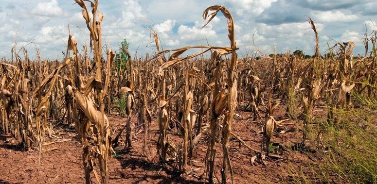
“Flash drought” has become a popular term in the media, but the debate of what a flash drought really is has caused confusion that affects scientists’ ability to detect their onset, monitor their development, and understand how they evolve. An online release in the Bulletin of the American Meteorological Society (BAMS) recommends that droughts which develop much more rapidly than normal be identified as flash droughts.
Published by Jason Otkin of the University of Wisconsin-Madison, the paper also discusses the importance of monitoring tools and forecasting methods, such as producing drought intensification forecasts at weekly intervals to show changes in conditions over subseasonal time scales. The focused definition of a flash drought provided by this study will help put in place the most appropriate monitoring and forecasting tools for such events to help advance the National Integrated Drought Information System (NIDIS).
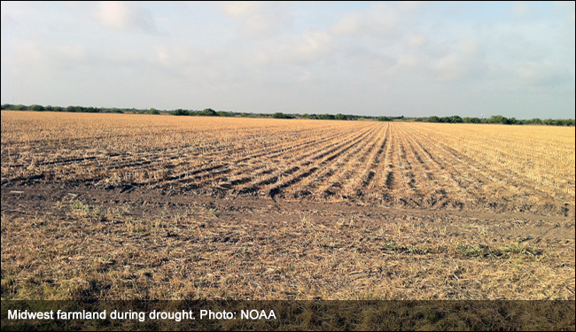
 Drought and flash drought rank second in terms of national weather-related economic impacts behind hurricanes, with annual losses nearing $9 billion in the United States, according to the National Oceanic and Atmospheric Administration. To provide earlier detection, the Quick Drought Response Index, or QuickDRI, went operational in June 2017 as a weekly drought alarm, providing improved sensitivity to early-stage drought conditions and rapidly evolving drought events.
“QuickDRI fills a gap in drought monitoring because of its sensitivity to short-term changes,” said Jesslyn Brown, a project co-investigator and lead for QuickDRI operations at the U.S. Geological Survey. “We expect it to be especially helpful for decisions related to irrigation and fire management.”
Like its companion Vegetation Drought Response Index, or VegDRI, which portrays drought’s effect on vegetation conditions, QuickDRI relies on a number of remotely-sensed indicators. Decades of satellite data housed at the USGS Earth Resources Observation and Science, or EROS, Center provide a resource for assessing abnormal vegetation and climate conditions over a longer historical period.
Drought and flash drought rank second in terms of national weather-related economic impacts behind hurricanes, with annual losses nearing $9 billion in the United States, according to the National Oceanic and Atmospheric Administration. To provide earlier detection, the Quick Drought Response Index, or QuickDRI, went operational in June 2017 as a weekly drought alarm, providing improved sensitivity to early-stage drought conditions and rapidly evolving drought events.
“QuickDRI fills a gap in drought monitoring because of its sensitivity to short-term changes,” said Jesslyn Brown, a project co-investigator and lead for QuickDRI operations at the U.S. Geological Survey. “We expect it to be especially helpful for decisions related to irrigation and fire management.”
Like its companion Vegetation Drought Response Index, or VegDRI, which portrays drought’s effect on vegetation conditions, QuickDRI relies on a number of remotely-sensed indicators. Decades of satellite data housed at the USGS Earth Resources Observation and Science, or EROS, Center provide a resource for assessing abnormal vegetation and climate conditions over a longer historical period.
 However, VegDRI is a seasonal drought indicator. As a geospatial tool to detect even faster-moving droughts, QuickDRI evolved to detect drought’s effects much more quickly.
“Preliminary assessment of QuickDRI shows that it consistently detects short-term dryness patterns across the continental U.S.,” said Dr. Brian Wardlow, the co-principal investigator of the QuickDRI project and director of the Center for Advanced Land Management Information Technologies at the University of Nebraska-Lincoln.
However, VegDRI is a seasonal drought indicator. As a geospatial tool to detect even faster-moving droughts, QuickDRI evolved to detect drought’s effects much more quickly.
“Preliminary assessment of QuickDRI shows that it consistently detects short-term dryness patterns across the continental U.S.,” said Dr. Brian Wardlow, the co-principal investigator of the QuickDRI project and director of the Center for Advanced Land Management Information Technologies at the University of Nebraska-Lincoln.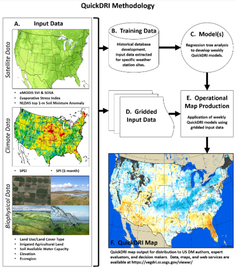 QuickDRI uses a variety of weekly inputs, including:
 “With the weekly updates provided by QuickDRI, the U.S. Drought Monitor authors have the ability to see changes quickly, which allows for more accurate and timely changes to the U.S. Drought Monitor map,” said Brian Fuchs, a U.S. Drought Monitor author at the NDMC. To learn more about QuickDRI, go to the USGS Drought Monitoring web site or the NDMC QuickDRI web site.
From NOAA and USGS
“With the weekly updates provided by QuickDRI, the U.S. Drought Monitor authors have the ability to see changes quickly, which allows for more accurate and timely changes to the U.S. Drought Monitor map,” said Brian Fuchs, a U.S. Drought Monitor author at the NDMC. To learn more about QuickDRI, go to the USGS Drought Monitoring web site or the NDMC QuickDRI web site.
From NOAA and USGS
Drought and flash drought rank second in terms of national weather-related economic impacts behind hurricanes, with annual losses nearing $9 billion in the United States, according to the National Oceanic and Atmospheric Administration. To provide earlier detection, the Quick Drought Response Index, or QuickDRI, went operational in June 2017 as a weekly drought alarm, providing improved sensitivity to early-stage drought conditions and rapidly evolving drought events.
“QuickDRI fills a gap in drought monitoring because of its sensitivity to short-term changes,” said Jesslyn Brown, a project co-investigator and lead for QuickDRI operations at the U.S. Geological Survey. “We expect it to be especially helpful for decisions related to irrigation and fire management.”
Like its companion Vegetation Drought Response Index, or VegDRI, which portrays drought’s effect on vegetation conditions, QuickDRI relies on a number of remotely-sensed indicators. Decades of satellite data housed at the USGS Earth Resources Observation and Science, or EROS, Center provide a resource for assessing abnormal vegetation and climate conditions over a longer historical period.
However, VegDRI is a seasonal drought indicator. As a geospatial tool to detect even faster-moving droughts, QuickDRI evolved to detect drought’s effects much more quickly.
“Preliminary assessment of QuickDRI shows that it consistently detects short-term dryness patterns across the continental U.S.,” said Dr. Brian Wardlow, the co-principal investigator of the QuickDRI project and director of the Center for Advanced Land Management Information Technologies at the University of Nebraska-Lincoln.
QuickDRI uses a variety of weekly inputs, including:
- A Soil Moisture Anomaly, which models soil moisture, from the NASA/NOAA North American Land Data Assimilation System;
- The Evaporative Stress Index, which is produced by the U.S. Department of Agriculture and shows evaporative moisture loss from plants;
- The Standardized Vegetation Index, based on a weekly Normalized Differentiated Vegetation Index (NDVI) that gauges plant vigor compared to historical norms;
- The Standardized Precipitation Index, an indicator of monthly precipitation as compared to normal; and
- Landscape characteristics such as soil texture, land cover and elevation.
“With the weekly updates provided by QuickDRI, the U.S. Drought Monitor authors have the ability to see changes quickly, which allows for more accurate and timely changes to the U.S. Drought Monitor map,” said Brian Fuchs, a U.S. Drought Monitor author at the NDMC. To learn more about QuickDRI, go to the USGS Drought Monitoring web site or the NDMC QuickDRI web site.
From NOAA and USGSAll Weather News
More
Flooding, Severe Storms Target the Midwest Again
After an active week of storms across the nor
31 Jul 2026 8:05 PM


After Reaching Category 5, Genevieve Weakens in the Pacific
PacificFausto is now a post-tropical cyclone.
31 Jul 2026 1:30 AM

Flooding Risk Increases as Heavy Rain Targets the Tri-State Area
Tuesday, heavy rainfall moved across the Nort
30 Jul 2026 12:25 AM

Severe Weather: Energy From the Midwest Now in the Southeast
UPPER MIDWEST - Through Monday, dangerous tor
29 Jul 2026 10:30 PM