Wildfire Burn Scars Posing Flash Flood Risk in California
Special Stories
22 Mar 2018 10:40 AM
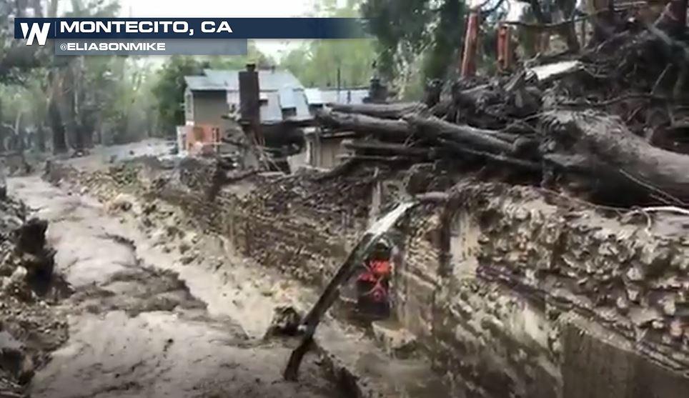
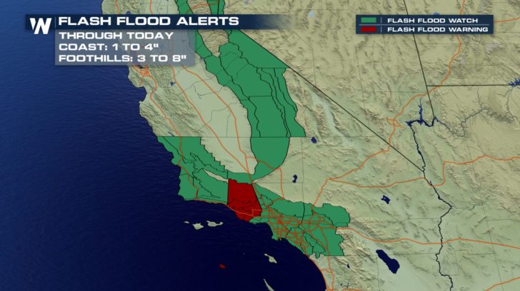
With the heavy rain that Southern California is getting, the National Weather Service is most concerned about the recent wildfire burn scar areas creating an elevated flood risk.
 https://twitter.com/WeatherNation/status/976861345948880898
The National Weather Service posted this graphic to explain why those wildfire burn scars are a flood risk.
https://twitter.com/WeatherNation/status/976861345948880898
The National Weather Service posted this graphic to explain why those wildfire burn scars are a flood risk.
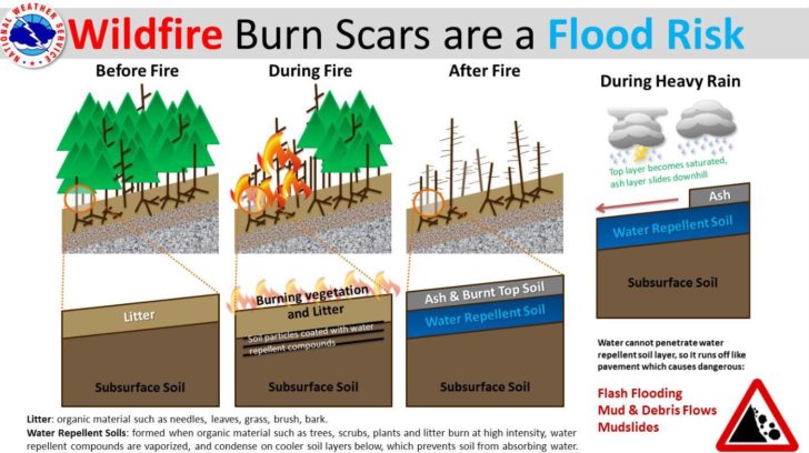 "Water repellent materials are created during wildfires that prevent the soil from absorbing water. Heavy rain runs off as it would run off of pavement...taking mud, rocks, and other debris along with it. This is why burn scars in steep terrain are so dangerous...and fires are often accelerated and burn hotter up steep slopes or canyons," the National Weather Service Office in Los Angeles writes.
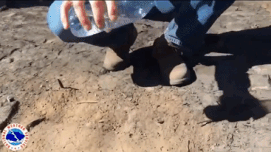
In this video, you can clearly see water falling onto the ground but after a recent fire in the area, the ground cannot absorb any of the water. It runs off, collects any loose debris, and heads downhill before coming to a halt downstream. In the same way, when rain comes down to those burn scar areas, boulders, trees, and other large debris gets picked up and they become extremely dangerous.
"Water repellent materials are created during wildfires that prevent the soil from absorbing water. Heavy rain runs off as it would run off of pavement...taking mud, rocks, and other debris along with it. This is why burn scars in steep terrain are so dangerous...and fires are often accelerated and burn hotter up steep slopes or canyons," the National Weather Service Office in Los Angeles writes.
In this video, you can clearly see water falling onto the ground but after a recent fire in the area, the ground cannot absorb any of the water. It runs off, collects any loose debris, and heads downhill before coming to a halt downstream. In the same way, when rain comes down to those burn scar areas, boulders, trees, and other large debris gets picked up and they become extremely dangerous.
 A more detailed explanation can be found here:
https://media.weathernationtv.com/news/debris-flows/
For more information about the dangers of debris flows and what causes them. Here’s WeatherNation’s John Van Pelt:
https://www.youtube.com/watch?v=_If_zQSJTDI
A more detailed explanation can be found here:
https://media.weathernationtv.com/news/debris-flows/
For more information about the dangers of debris flows and what causes them. Here’s WeatherNation’s John Van Pelt:
https://www.youtube.com/watch?v=_If_zQSJTDI
https://twitter.com/WeatherNation/status/976861345948880898
The National Weather Service posted this graphic to explain why those wildfire burn scars are a flood risk.
"Water repellent materials are created during wildfires that prevent the soil from absorbing water. Heavy rain runs off as it would run off of pavement...taking mud, rocks, and other debris along with it. This is why burn scars in steep terrain are so dangerous...and fires are often accelerated and burn hotter up steep slopes or canyons," the National Weather Service Office in Los Angeles writes.
In this video, you can clearly see water falling onto the ground but after a recent fire in the area, the ground cannot absorb any of the water. It runs off, collects any loose debris, and heads downhill before coming to a halt downstream. In the same way, when rain comes down to those burn scar areas, boulders, trees, and other large debris gets picked up and they become extremely dangerous.
A more detailed explanation can be found here:
https://media.weathernationtv.com/news/debris-flows/
For more information about the dangers of debris flows and what causes them. Here’s WeatherNation’s John Van Pelt:
https://www.youtube.com/watch?v=_If_zQSJTDI
All Weather News
More

More Storms for the East Through Monday
A low-pressure system that moved through the
3 Aug 2026 12:20 PM


After Reaching Category 5, Genevieve Weakens in the Pacific
PacificGenevieve formed last Friday south of
3 Aug 2026 12:30 AM

Flooding, Severe Storms Target the Midwest Again
After an active week of storms across the nor
1 Aug 2026 1:40 AM

Flooding Risk Increases as Heavy Rain Targets the Tri-State Area
Tuesday, heavy rainfall moved across the Nort
30 Jul 2026 12:25 AM