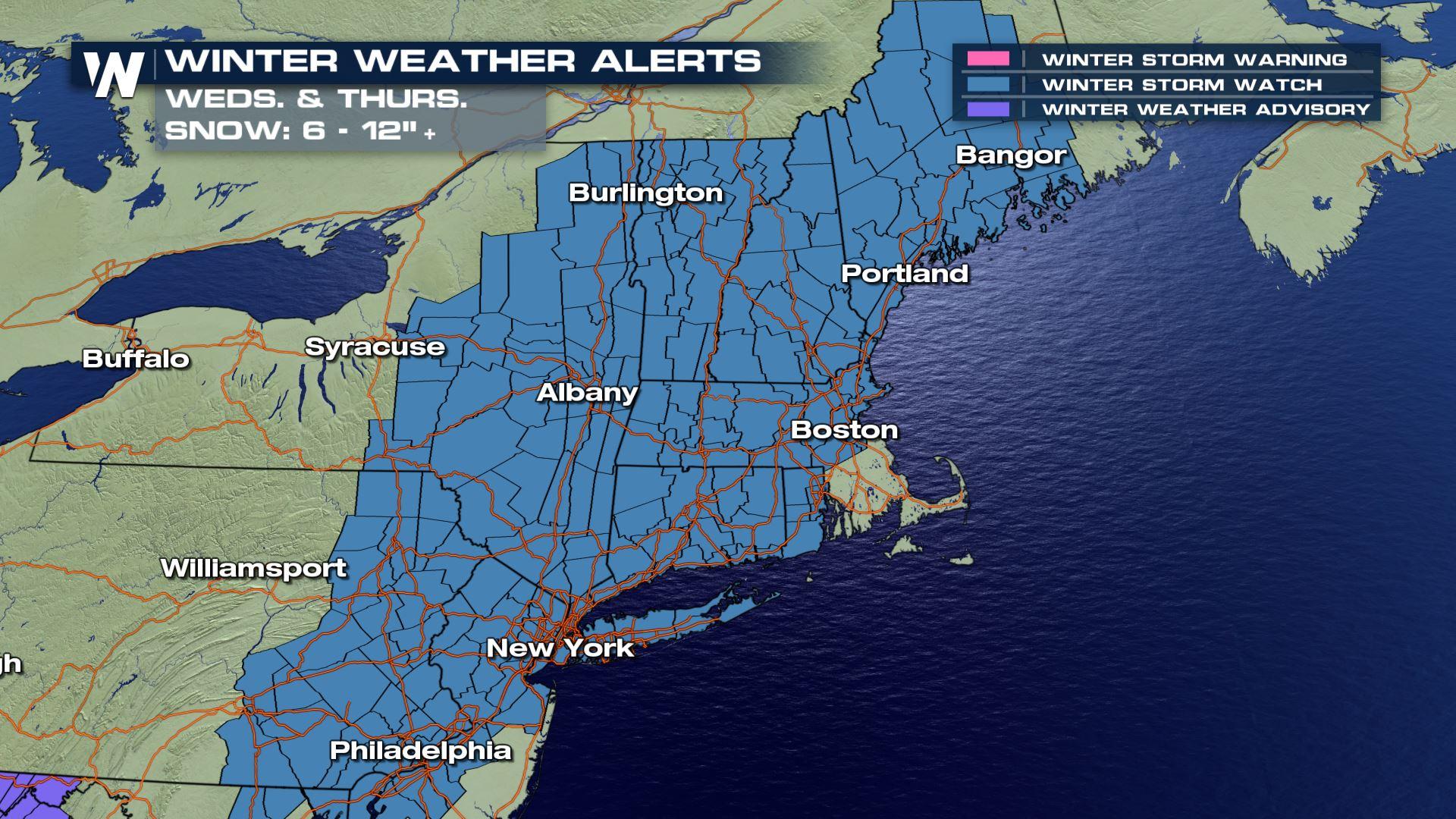
Winter Storm Watch for Much of Northeast
Top Stories
5 Mar 2018 3:25 PM
After the most powerful wind storm the Northeast U.S. had seen in years, another one is on tap - and this one looks to be far snowier for the big cities.
Boston, New York City and Philadelphia were all placed under Winter Storm Watches on Monday as the second major winter storm in less than a week bears down on the I-95 corridor. Another nor'easter will develop off the mid-Atlantic coastline on Tuesday night and work its way up the Atlantic coastline, battering some coastal areas with rain, but most will see heavy snow and gusty winds.
 There are several big differences between last week's storm, which knocked out power to hundreds of thousands with tens of thousands still without electricity as of Monday afternoon. This storm will have some wind issues, but it won't be nearly the powerful wind-maker that last week's storm was. This one, however, promises to potentially deliver the East Coast's coastal cities with more snowfall than last week's storm.
Right now, New York and Boston look to get potentially six inches or more of snowfall, while Philadelphia stands to get around 3 to 6 inches on Wednesday into Wednesday night. All three cities' northwest suburbs stand to get higher accumulations as they'll be colder and further away from the warming influence of the sea. This forecast will likely change between now and Wednesday, with some of the computer models trending towards higher totals on Monday.
There are several big differences between last week's storm, which knocked out power to hundreds of thousands with tens of thousands still without electricity as of Monday afternoon. This storm will have some wind issues, but it won't be nearly the powerful wind-maker that last week's storm was. This one, however, promises to potentially deliver the East Coast's coastal cities with more snowfall than last week's storm.
Right now, New York and Boston look to get potentially six inches or more of snowfall, while Philadelphia stands to get around 3 to 6 inches on Wednesday into Wednesday night. All three cities' northwest suburbs stand to get higher accumulations as they'll be colder and further away from the warming influence of the sea. This forecast will likely change between now and Wednesday, with some of the computer models trending towards higher totals on Monday.
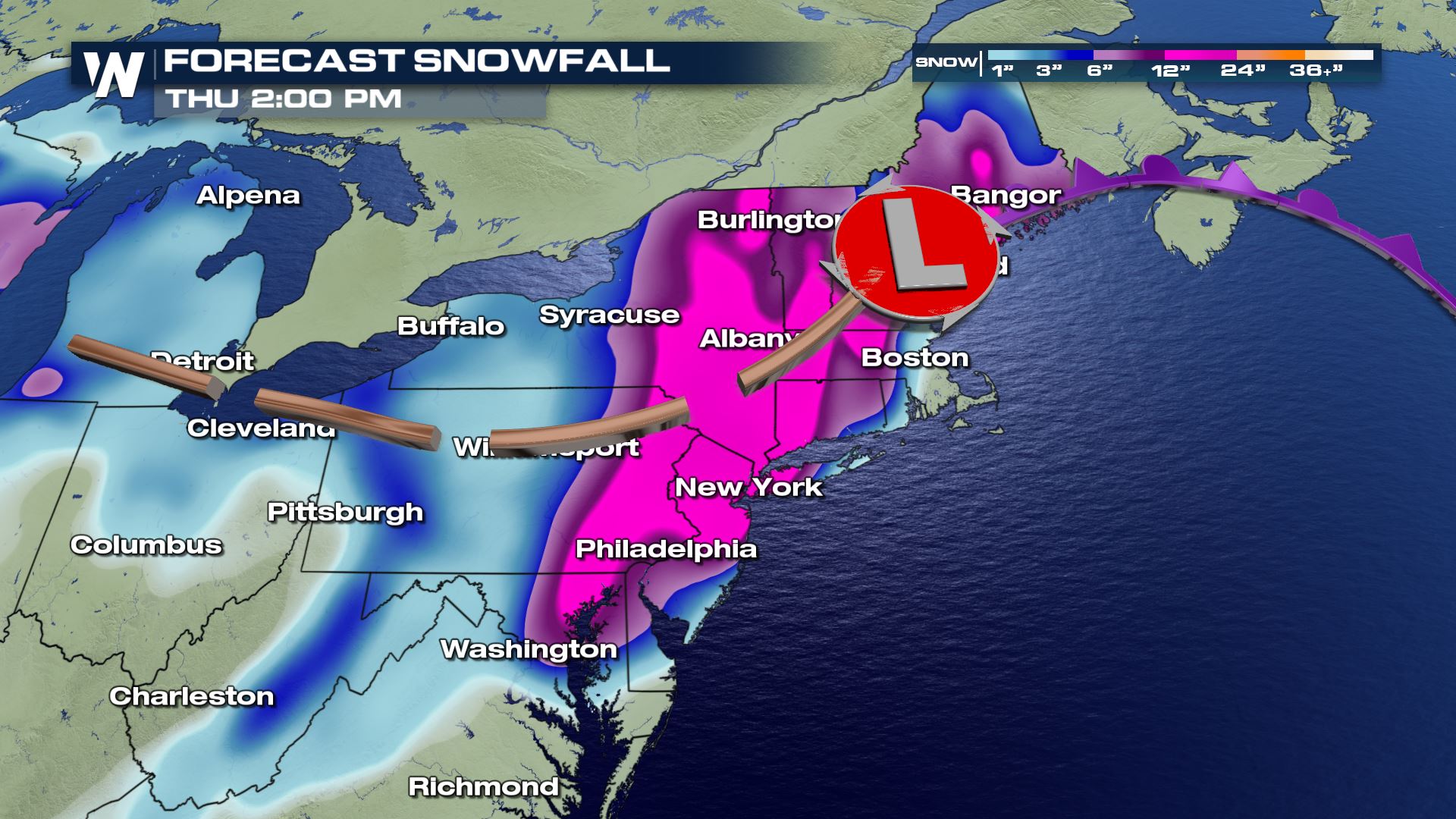 Portions of interior New England and upstate New York could see as much as 18-24", as highlighted in pink in the map above.
Stay with WeatherNation for the latest on this significant winter storm.
For WeatherNation: Meteorologist Chris Bianchi
Portions of interior New England and upstate New York could see as much as 18-24", as highlighted in pink in the map above.
Stay with WeatherNation for the latest on this significant winter storm.
For WeatherNation: Meteorologist Chris Bianchi
There are several big differences between last week's storm, which knocked out power to hundreds of thousands with tens of thousands still without electricity as of Monday afternoon. This storm will have some wind issues, but it won't be nearly the powerful wind-maker that last week's storm was. This one, however, promises to potentially deliver the East Coast's coastal cities with more snowfall than last week's storm.
Right now, New York and Boston look to get potentially six inches or more of snowfall, while Philadelphia stands to get around 3 to 6 inches on Wednesday into Wednesday night. All three cities' northwest suburbs stand to get higher accumulations as they'll be colder and further away from the warming influence of the sea. This forecast will likely change between now and Wednesday, with some of the computer models trending towards higher totals on Monday.
Portions of interior New England and upstate New York could see as much as 18-24", as highlighted in pink in the map above.
Stay with WeatherNation for the latest on this significant winter storm.
For WeatherNation: Meteorologist Chris BianchiAll Weather News
More
Wildfire Outbreak in the Pacific Northwest
SPOKANE, WA - On Saturday, August 1st, the Ol
2 Aug 2026 7:20 PM

More Storms for the East Through Monday
A low-pressure system that moved through the
2 Aug 2026 7:20 PM


After Reaching Category 5, Genevieve Weakens in the Pacific
PacificGenevieve formed on last Friday south
2 Aug 2026 6:25 PM

Flooding, Severe Storms Target the Midwest Again
After an active week of storms across the nor
1 Aug 2026 1:40 AM

Flooding Risk Increases as Heavy Rain Targets the Tri-State Area
Tuesday, heavy rainfall moved across the Nort
30 Jul 2026 12:25 AM

Severe Weather: Energy From the Midwest Now in the Southeast
UPPER MIDWEST - Through Monday, dangerous tor
29 Jul 2026 10:30 PM