Sunday Soaker for the Southeast

Top Stories
25 Jan 2018 10:32 PM
Heavy rain and thunderstorms are likely for the Southeastern United States this weekend, especially on Sunday. Warm, moist air from the Gulf of Mexico will begin moving northeast through Texas, Arkansas, and Louisiana Saturday and then through Mississippi, Alabama, Georgia, and Florida on Sunday.
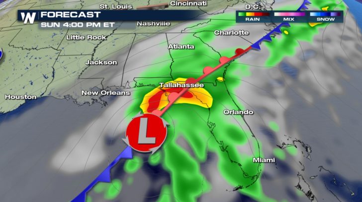 Weather forecast for Sunday, January 28 where green shows rain, yellow and red shows heavy rain and thunderstorms, and gray shows cloud cover.
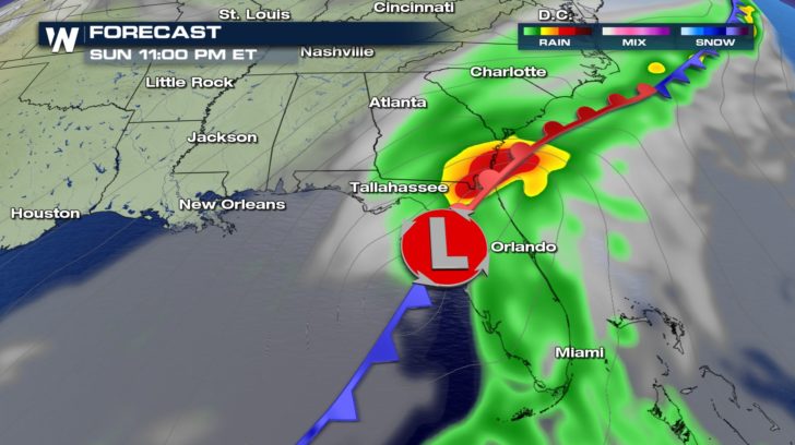
 Weather forecast for Sunday, January 28 where green shows rain, yellow and red shows heavy rain and thunderstorms, and gray shows cloud cover.
The rainfall will be heaviest Sunday and Sunday night for most of the Southeast, resulting in a widespread 1 to 3 inches of rainfall but up to 6 inches in localized spots.
Weather forecast for Sunday, January 28 where green shows rain, yellow and red shows heavy rain and thunderstorms, and gray shows cloud cover.
The rainfall will be heaviest Sunday and Sunday night for most of the Southeast, resulting in a widespread 1 to 3 inches of rainfall but up to 6 inches in localized spots.
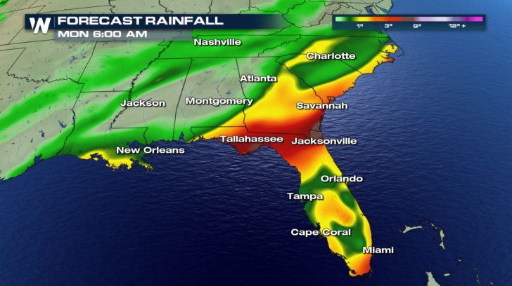 Rainfall forecast now through Monday, January 29 where yellow shows 1"+, orange shows 2"+, red shows 3"+ and browns show up to 6"
The impacts of this heavy rain will include water ponding on the roadways, minor flooding in low-lying areas, and rises on area rivers and streams. Avoid flooded roadways and turn around if the road ahead is covered in water. Some flooding may occur at night, making it harder to see.
Areas along the East coast should watch where this low pressure system goes after it leaves the Southeast, because it may be close enough to have a snowy influence in parts of the Northeast on Monday night. Right now, a light to moderate wintry mix or plain snow is possible on Monday night. Here's what the map looks like on Monday afternoon.
Rainfall forecast now through Monday, January 29 where yellow shows 1"+, orange shows 2"+, red shows 3"+ and browns show up to 6"
The impacts of this heavy rain will include water ponding on the roadways, minor flooding in low-lying areas, and rises on area rivers and streams. Avoid flooded roadways and turn around if the road ahead is covered in water. Some flooding may occur at night, making it harder to see.
Areas along the East coast should watch where this low pressure system goes after it leaves the Southeast, because it may be close enough to have a snowy influence in parts of the Northeast on Monday night. Right now, a light to moderate wintry mix or plain snow is possible on Monday night. Here's what the map looks like on Monday afternoon.
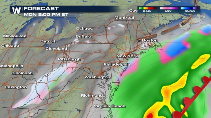 Weather forecast for Monday, January 29 where green shows rain, yellow and red shows heavy rain and thunderstorms, and gray shows cloud cover. Pink and blue show a wintry mix or snow.
As we get closer to next week's forecast, we'll have much more detail on the Northeast expectation and impacts.
For WeatherNation, Meteorologist Steve Glazier
Weather forecast for Monday, January 29 where green shows rain, yellow and red shows heavy rain and thunderstorms, and gray shows cloud cover. Pink and blue show a wintry mix or snow.
As we get closer to next week's forecast, we'll have much more detail on the Northeast expectation and impacts.
For WeatherNation, Meteorologist Steve Glazier
Weather forecast for Sunday, January 28 where green shows rain, yellow and red shows heavy rain and thunderstorms, and gray shows cloud cover.
Weather forecast for Sunday, January 28 where green shows rain, yellow and red shows heavy rain and thunderstorms, and gray shows cloud cover.
The rainfall will be heaviest Sunday and Sunday night for most of the Southeast, resulting in a widespread 1 to 3 inches of rainfall but up to 6 inches in localized spots.
Rainfall forecast now through Monday, January 29 where yellow shows 1"+, orange shows 2"+, red shows 3"+ and browns show up to 6"
The impacts of this heavy rain will include water ponding on the roadways, minor flooding in low-lying areas, and rises on area rivers and streams. Avoid flooded roadways and turn around if the road ahead is covered in water. Some flooding may occur at night, making it harder to see.
Areas along the East coast should watch where this low pressure system goes after it leaves the Southeast, because it may be close enough to have a snowy influence in parts of the Northeast on Monday night. Right now, a light to moderate wintry mix or plain snow is possible on Monday night. Here's what the map looks like on Monday afternoon.
Weather forecast for Monday, January 29 where green shows rain, yellow and red shows heavy rain and thunderstorms, and gray shows cloud cover. Pink and blue show a wintry mix or snow.
As we get closer to next week's forecast, we'll have much more detail on the Northeast expectation and impacts.
For WeatherNation, Meteorologist Steve GlazierAll Weather News
More
Severe Storm Threat Returns to the Midwest
After several tornadoes ripped through the Mi
30 Jul 2026 9:30 PM


After Reaching Category 5, Genevieve Weakens in the Pacific
PacificFausto is now a post-tropical cyclone.
30 Jul 2026 12:00 PM

Flooding Risk Increases as Heavy Rain Targets the Tri-State Area
Tuesday, heavy rainfall moved across the Nort
30 Jul 2026 12:25 AM

Severe Weather: Energy From the Midwest Now in the Southeast
UPPER MIDWEST - Through Monday, dangerous tor
29 Jul 2026 10:30 PM

Southeast Flood Risk Lingers Near Stalled Front
A stalled boundary over the Southeast will ke
25 Jul 2026 10:55 AM