Snow For The Ozarks Monday

Special Stories
11 Nov 2018 3:54 PM
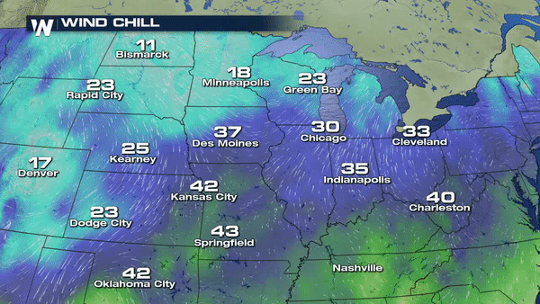
Once again, bone chilling cold temperatures are carving across the Upper Midwest and Central Plains. Wind chill readings were in the single digits on Sunday for parts of the High Plains.
Sunday high temperatures for the High Plains were running approximately 10-20° below normal for this time of year.
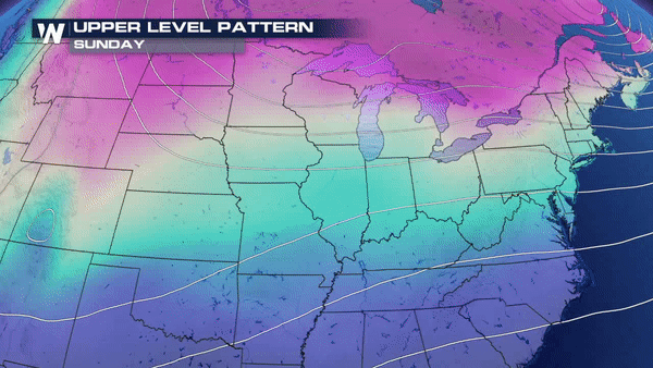
 This cold air will meet up with more moisture coming in from the southwest by this evening.
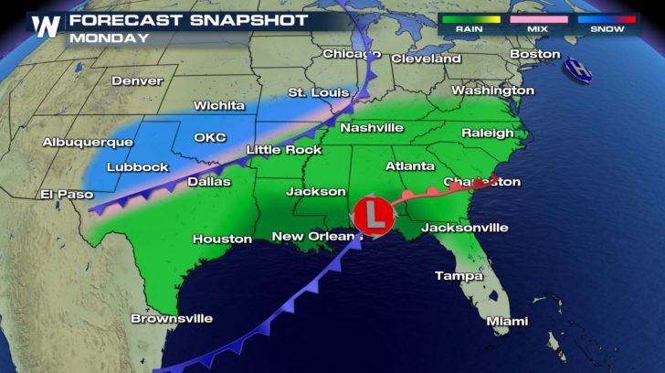
 This means more accumulating snow for the Midwest and heavy rain for the Southeast beginning tonight for western Kansas, Oklahoma and Texas and continuing for Missouri and Ohio Valley by Monday and Tuesday.
A good to 1"-3" snow range expected on Monday for the Central Plains and the Ozarks. Heavier amounts closer to 6 inches are possible for the panhandle of Texas expected to begin tonight.
This means more accumulating snow for the Midwest and heavy rain for the Southeast beginning tonight for western Kansas, Oklahoma and Texas and continuing for Missouri and Ohio Valley by Monday and Tuesday.
A good to 1"-3" snow range expected on Monday for the Central Plains and the Ozarks. Heavier amounts closer to 6 inches are possible for the panhandle of Texas expected to begin tonight.
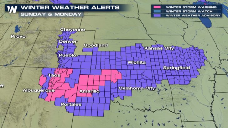
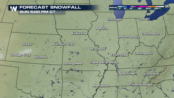 Snow will changeover across the Ozarks beginning late Monday and lasting into the evening hours. Light accumulations expected so widespread travel issues are not a major concern;however, there could be some isolated slick spots that will be likely on bridges and elevated surfaces Monday night and Tuesday morning as temps take a nose dive below freezing.
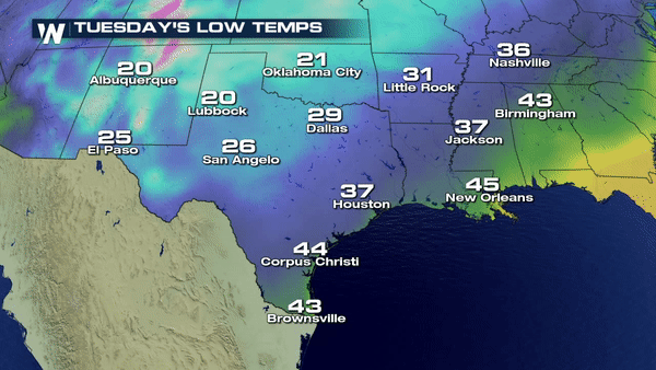 Clearing skies for the Midwest by Tuesday but you'll need extra layers, folks. Extra layers! Going to be c-c-cold as you step out the door Tuesday morning.

This cold air will meet up with more moisture coming in from the southwest by this evening.
This means more accumulating snow for the Midwest and heavy rain for the Southeast beginning tonight for western Kansas, Oklahoma and Texas and continuing for Missouri and Ohio Valley by Monday and Tuesday.
A good to 1"-3" snow range expected on Monday for the Central Plains and the Ozarks. Heavier amounts closer to 6 inches are possible for the panhandle of Texas expected to begin tonight.
Snow will changeover across the Ozarks beginning late Monday and lasting into the evening hours. Light accumulations expected so widespread travel issues are not a major concern;however, there could be some isolated slick spots that will be likely on bridges and elevated surfaces Monday night and Tuesday morning as temps take a nose dive below freezing.
Clearing skies for the Midwest by Tuesday but you'll need extra layers, folks. Extra layers! Going to be c-c-cold as you step out the door Tuesday morning.
All Weather News
More


More Storms for the East Sunday and Monday
A low-pressure system crashing through the Mi
2 Aug 2026 2:20 AM

After Reaching Category 5, Genevieve Weakens in the Pacific
PacificGenevieve formed on last Friday south
2 Aug 2026 1:30 AM

Flooding, Severe Storms Target the Midwest Again
After an active week of storms across the nor
1 Aug 2026 1:40 AM

Flooding Risk Increases as Heavy Rain Targets the Tri-State Area
Tuesday, heavy rainfall moved across the Nort
30 Jul 2026 12:25 AM

Severe Weather: Energy From the Midwest Now in the Southeast
UPPER MIDWEST - Through Monday, dangerous tor
29 Jul 2026 10:30 PM