Updated January Forecast from the NOAA's Climate Prediction Center
Special Stories
2 Jan 2018 5:26 PM
On Sunday, NOAA's Climate Prediction Center updated their 30 day forecast for January. Colder than average temperatures are still expected across the Great Lakes, but have been expanded to include most of the eastern half of the nation. Warmer than normal temperatures have been shoved slightly westward, from the Four Corners to the Pacific Ocean.
https://twitter.com/NWSCPC/status/947565992397467648
In the precipitation forecast, a few adjustments have also been made. Areas along the Pacific Coast are likely to see below average precipitation, replacing the wetter than normal forecast from a couple of weeks ago. Those looking for snow in the Upper Midwest may be disappointed as an area of drier than normal weather is now in the January outlook. Below normal precipitation is still expected in the south, along with wetter than average conditions in the Ohio Valley. The previous January forecast was issued on December 21st.
https://twitter.com/NWSCPC/status/943839827828584448
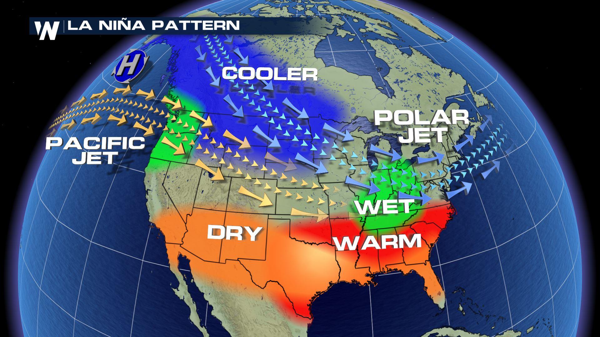
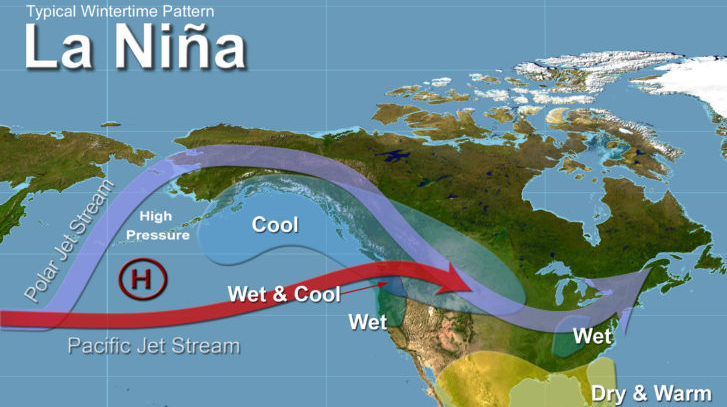
The Climate Prediction Center noted that the forecast was based on model guidance , current ongoing trends in the atmosphere globally, and typical influences of La Nina. The discussion said, "the current state of La Nina and seasonal trends provide backdrop for the monthly outlook.
La Nina conditions are being observed in the Pacific Ocean and are expected to continue through the beginning of the year. La Nina (translated from Spanish as “little girl”) is a natural ocean-atmospheric phenomenon marked by cooler-than-average sea surface temperatures in the central Pacific Ocean near the equator. It's the opposite of El Nino (“little boy”), which is when warmer than normal water temperatures are observed.
Typical La Nina patterns during winter include above-average precipitation and colder-than-average temperatures along the northern tier of the U.S. and below-normal precipitation and drier conditions across the South.
For WeatherNation: Meteorologist Mace Michaels
All Weather News
More
East Gears Up for Stormy, Wet Weekend
A low pressure system crashing through the Mi
1 Aug 2026 11:35 AM


Flooding, Severe Storms Target the Midwest Again
After an active week of storms across the nor
1 Aug 2026 1:40 AM


After Reaching Category 5, Genevieve Weakens in the Pacific
PacificFausto is now a post-tropical cyclone.
31 Jul 2026 1:30 AM

Flooding Risk Increases as Heavy Rain Targets the Tri-State Area
Tuesday, heavy rainfall moved across the Nort
30 Jul 2026 12:25 AM

Severe Weather: Energy From the Midwest Now in the Southeast
UPPER MIDWEST - Through Monday, dangerous tor
29 Jul 2026 10:30 PM