A Look at Hurricane Edouard's Rapidly Intensification from 2014

Special Stories
11 Nov 2019 2:32 AM
[Hurricane Edouard from 2014. From NOAA via Wikimedia Commons]
[NOAA] In 2014, Hurricane Edouard became the first major hurricane in the Atlantic Ocean since Hurricane Sandy, two years earlier. Thankfully the storm stayed well out to sea, several hundred miles east of Bermuda. Most tropical cyclones usually weaken when there is a large change in the wind speed or direction with height (wind shear) or when there is dry air in the core. But Hurricane Edouard intensified rapidly under these conditions. A new study used a series of model runs to understand how a hurricane can moisten under these conditions.
 Important Conclusions from the study:
Important Conclusions from the study:
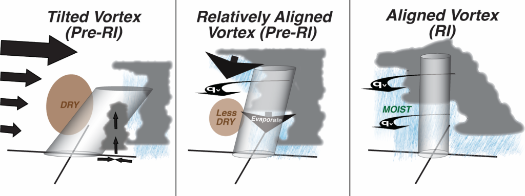
- Wind shear can cause the tropical cyclone center to be in different locations with height. When the centers are in the same location with height (what we call alignment), conditions are favorable for rapid intensification. The alignment appears to result from both persistent thunderstorms and the motion of centers at different heights.
- As rain falls, the water evaporates, moistening the air. After the tropical cyclone becomes more aligned, but before rapid intensification, moisture moves from where the convection is occurring into drier areas in the core. This, and the evaporating rain, helps to moisten the otherwise unfavorable, dry middle layers of the atmosphere.
All Weather News
More
More Storms for the East Through Monday
A low-pressure system that moved through the
2 Aug 2026 10:40 PM

Wildfire Outbreak in the Pacific Northwest
SPOKANE, WA - On Saturday, August 1st, the Ol
2 Aug 2026 10:35 PM


After Reaching Category 5, Genevieve Weakens in the Pacific
PacificGenevieve formed on last Friday south
2 Aug 2026 6:25 PM

Flooding, Severe Storms Target the Midwest Again
After an active week of storms across the nor
1 Aug 2026 1:40 AM

Flooding Risk Increases as Heavy Rain Targets the Tri-State Area
Tuesday, heavy rainfall moved across the Nort
30 Jul 2026 12:25 AM

Severe Weather: Energy From the Midwest Now in the Southeast
UPPER MIDWEST - Through Monday, dangerous tor
29 Jul 2026 10:30 PM