Developing: Tornado Watch Issued for Mid-Atlantic
Top Stories
12 May 2018 1:14 PM
Updated 5:10 p.m. Eastern Saturday
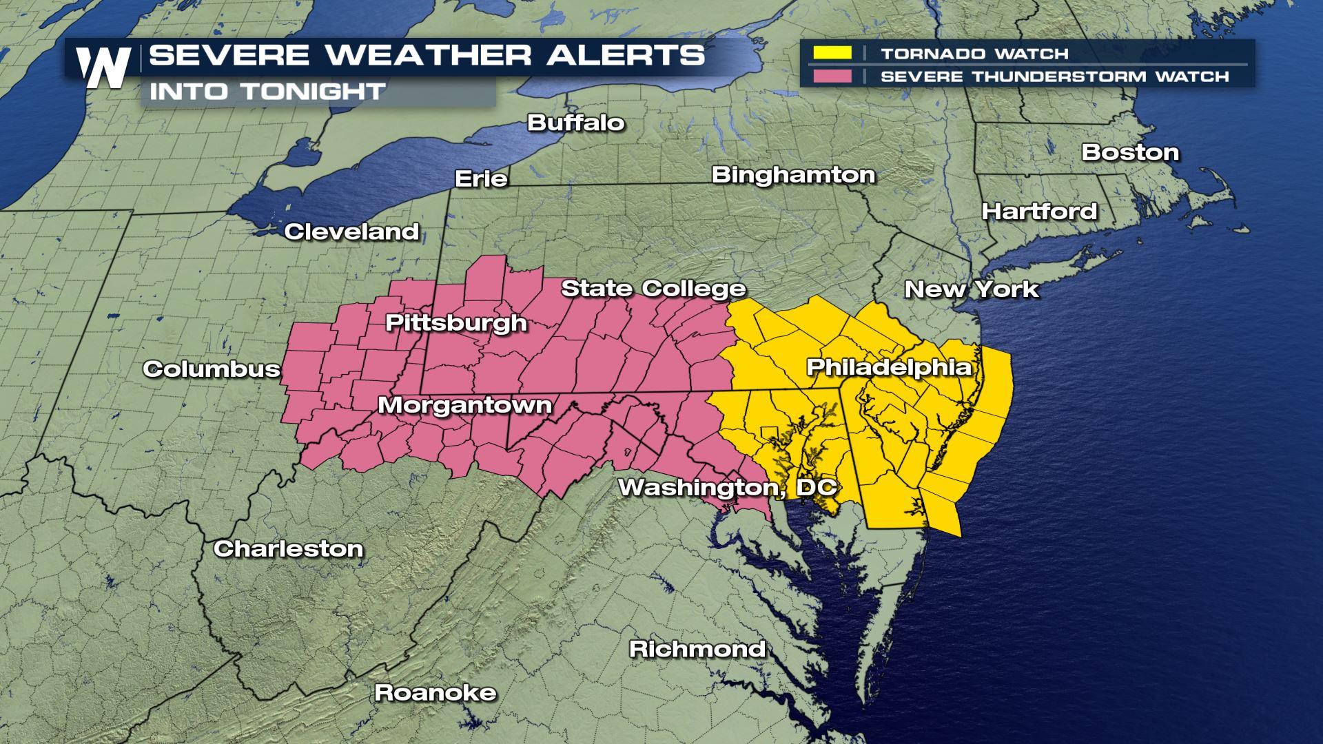
*A new tornado watch has been issued through this evening for the Baltimore and Philadelphia areas. This is shown in yellow below.
https://twitter.com/WeatherNation/status/995408251561758720
Severe weather is beginning to pop up and will continue to do so through this evening across the Ohio Valley, central Appalachians, and mid-Atlantic coastline. Earlier this afternoon the Storm Prediction Center issued a severe thunderstorm watch in anticipation of storms for the rest of today.
The primary hazards with today's storms will be damaging winds up to 70 miles per hour, perhaps even an isolated stronger gust. A line of strong to severe thunderstorms is expected to develop and push eastward through midnight. Here's the timing:
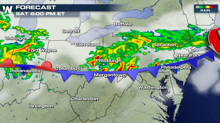 Forecast at 6 p.m. eastern Saturday where yellows and reds show where the projected storms are expected to be.
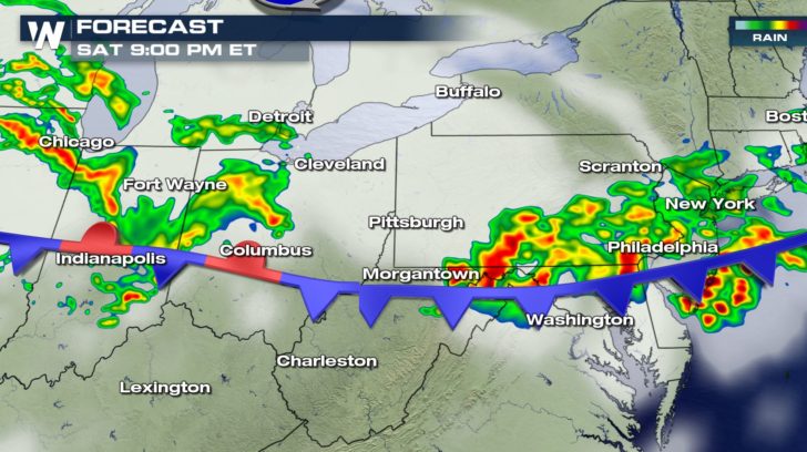 Forecast at 9 p.m. eastern Saturday where yellows and reds show where the projected storms are expected to be.
Showers and thunderstorms will move to the east around 35-40 miles per hour, but could move as quickly as 55 mph! Thus, these storms may sneak up on some of us. If you hear of a warning, that means take action immediately. For most people and scenarios, it means getting into the most interior section of a sturdy structure.
Forecast at 9 p.m. eastern Saturday where yellows and reds show where the projected storms are expected to be.
Showers and thunderstorms will move to the east around 35-40 miles per hour, but could move as quickly as 55 mph! Thus, these storms may sneak up on some of us. If you hear of a warning, that means take action immediately. For most people and scenarios, it means getting into the most interior section of a sturdy structure.
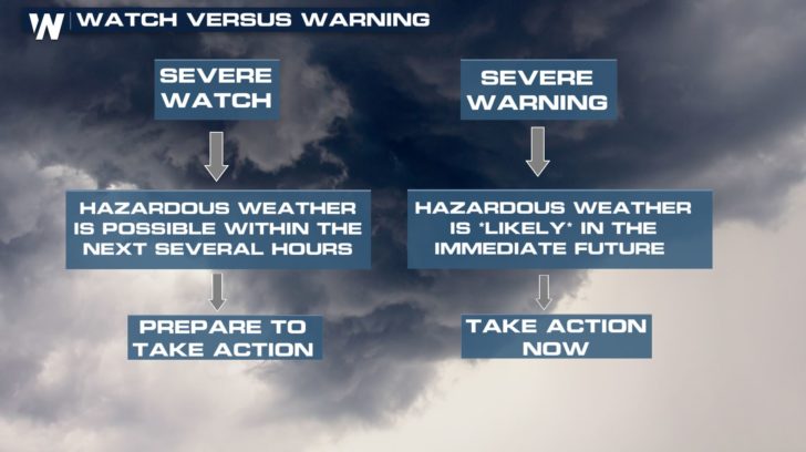 ^^Good-to-know information between watches and warnings!^^
Approximately 7.7 million people were under the initial severe thunderstorm watch.
https://twitter.com/NWSEastern/status/995375162504642561
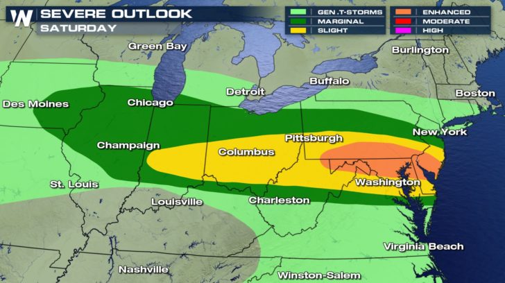
This is part of a large area that has a chance at severe weather today.
^^Good-to-know information between watches and warnings!^^
Approximately 7.7 million people were under the initial severe thunderstorm watch.
https://twitter.com/NWSEastern/status/995375162504642561
This is part of a large area that has a chance at severe weather today.
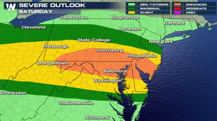 The severe weather outlook Saturday, May 12 where orange is enhanced, meaning numerous severe storms are expected. Light green is general, meaning severe weather is not anticipated.
 Once again, damaging wind gusts will be today's biggest concern!
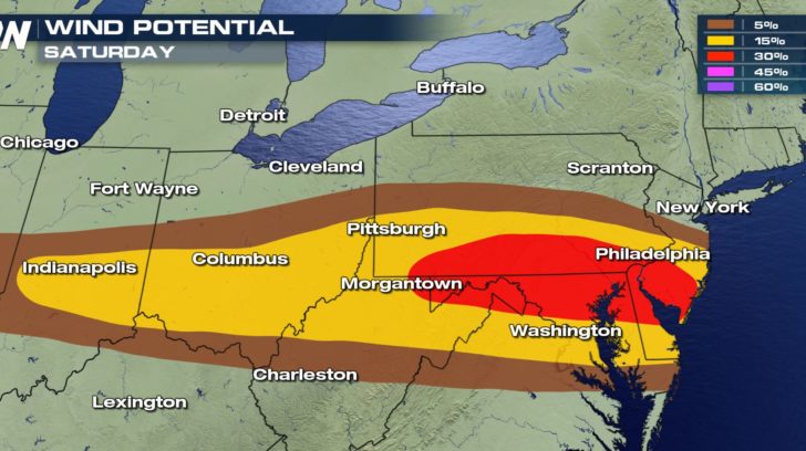 The wind potential means there is "X" percent chance (5, 15, and 30 above) of severe wind gusts within 25 miles of any point. It's quite a large area today! Keep an eye to the sky, listen out for thunder and weather alerts, and be weather ready!
For WeatherNation, Meteorologist Steve Glazier
The wind potential means there is "X" percent chance (5, 15, and 30 above) of severe wind gusts within 25 miles of any point. It's quite a large area today! Keep an eye to the sky, listen out for thunder and weather alerts, and be weather ready!
For WeatherNation, Meteorologist Steve Glazier
Forecast at 6 p.m. eastern Saturday where yellows and reds show where the projected storms are expected to be.
Forecast at 9 p.m. eastern Saturday where yellows and reds show where the projected storms are expected to be.
Showers and thunderstorms will move to the east around 35-40 miles per hour, but could move as quickly as 55 mph! Thus, these storms may sneak up on some of us. If you hear of a warning, that means take action immediately. For most people and scenarios, it means getting into the most interior section of a sturdy structure.
^^Good-to-know information between watches and warnings!^^
Approximately 7.7 million people were under the initial severe thunderstorm watch.
https://twitter.com/NWSEastern/status/995375162504642561
This is part of a large area that has a chance at severe weather today.
The severe weather outlook Saturday, May 12 where orange is enhanced, meaning numerous severe storms are expected. Light green is general, meaning severe weather is not anticipated.
Once again, damaging wind gusts will be today's biggest concern!
The wind potential means there is "X" percent chance (5, 15, and 30 above) of severe wind gusts within 25 miles of any point. It's quite a large area today! Keep an eye to the sky, listen out for thunder and weather alerts, and be weather ready!
For WeatherNation, Meteorologist Steve GlazierAll Weather News
More
East Gears Up for Stormy, Wet Weekend
A low pressure system crashing through the Mi
1 Aug 2026 11:35 PM


Flooding, Severe Storms Target the Midwest Again
After an active week of storms across the nor
1 Aug 2026 1:40 AM

After Reaching Category 5, Genevieve Weakens in the Pacific
PacificFausto is now a post-tropical cyclone.
31 Jul 2026 1:30 AM

Flooding Risk Increases as Heavy Rain Targets the Tri-State Area
Tuesday, heavy rainfall moved across the Nort
30 Jul 2026 12:25 AM

Severe Weather: Energy From the Midwest Now in the Southeast
UPPER MIDWEST - Through Monday, dangerous tor
29 Jul 2026 10:30 PM