Drones Provide a New Frontier in Hurricane Observations
Special Stories
8 Dec 2019 2:22 AM
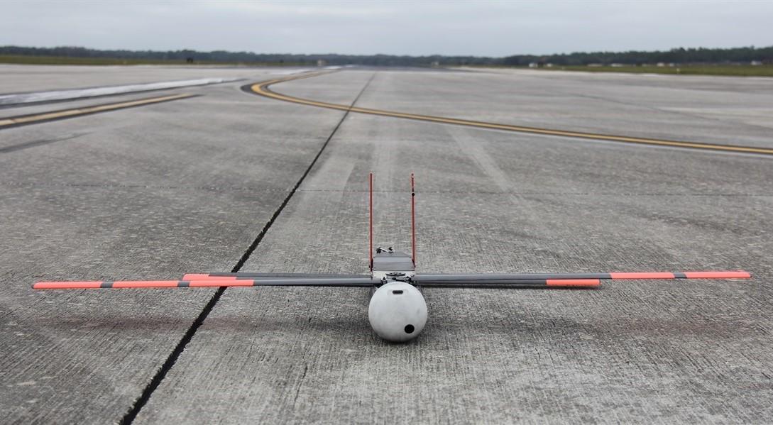
[NOAA Coyote drone in Avon Park, FL. From NOAA]
[NCAR] Scientists for years have speculated about the powerful hurricane winds that blast just above the surface of the ocean near the eyewall of the storm. These winds, often the most intense in the storm, play a critical role in lifting energy and moisture from the warm ocean waters into the atmosphere, influencing the intensity and path of the hurricane. But they are too dangerous for research aircraft to fly through.
Now a new type of disposable drone will enable scientists to collect detailed observations of these winds. Scientists in 2017 and 2018 flew the Coyote unmanned aircraft into hurricanes Maria and Michael, two of the most powerful Atlantic basin hurricanes on record. The unmanned aerial system (UAS) measured atmospheric conditions as low as 360 feet above the water and winds of up to 194 miles per hour.
A new paper by a team of scientists, led by the National Oceanic and Atmospheric Administration (NOAA) and National Center for Atmospheric Research (NCAR), demonstrates that such observations can improve the performance of hurricane models used by forecasters.
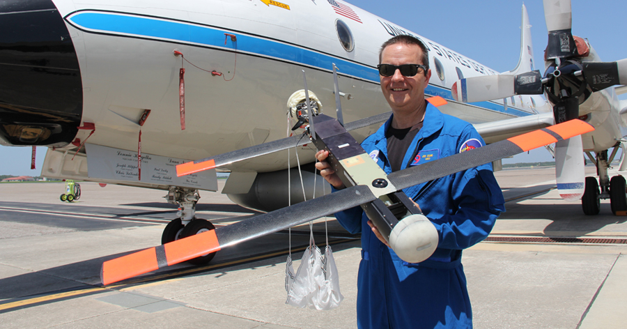 [NOAA scientist Joe Cione, lead author of a new paper on using disposable drones for hurricane observations, holds a Coyote drone in front of a NOAA P-3 "hurricane hunter" research aircraft at McDill Air Force Base in Tampa, Fla. Image courtesy of NOAA.]
"We have an instrument to collect data that we've never been able to collect before," said NCAR scientist George Bryan, a co-author of the new paper. "This is a new frontier in measuring the atmosphere."
The observations will enable scientists to determine the extent to which the gusts shift and fluctuate, which can have significant implications for hurricane behavior as well as the potential for damage once the storm moves onshore.
Bryan said the drone's measurements may also help answer a longstanding question about the interplay of hurricane winds and the ocean surface. Strong winds typically whip up ocean waves, which then exert a drag on the winds that can slow them down. Some evidence, however, indicates that hurricane-force winds cause waves to break in a way that would not exert such a drag, as well as stirring up so much froth that the water surface essentially has a lubricating effect.
[NOAA scientist Joe Cione, lead author of a new paper on using disposable drones for hurricane observations, holds a Coyote drone in front of a NOAA P-3 "hurricane hunter" research aircraft at McDill Air Force Base in Tampa, Fla. Image courtesy of NOAA.]
"We have an instrument to collect data that we've never been able to collect before," said NCAR scientist George Bryan, a co-author of the new paper. "This is a new frontier in measuring the atmosphere."
The observations will enable scientists to determine the extent to which the gusts shift and fluctuate, which can have significant implications for hurricane behavior as well as the potential for damage once the storm moves onshore.
Bryan said the drone's measurements may also help answer a longstanding question about the interplay of hurricane winds and the ocean surface. Strong winds typically whip up ocean waves, which then exert a drag on the winds that can slow them down. Some evidence, however, indicates that hurricane-force winds cause waves to break in a way that would not exert such a drag, as well as stirring up so much froth that the water surface essentially has a lubricating effect.
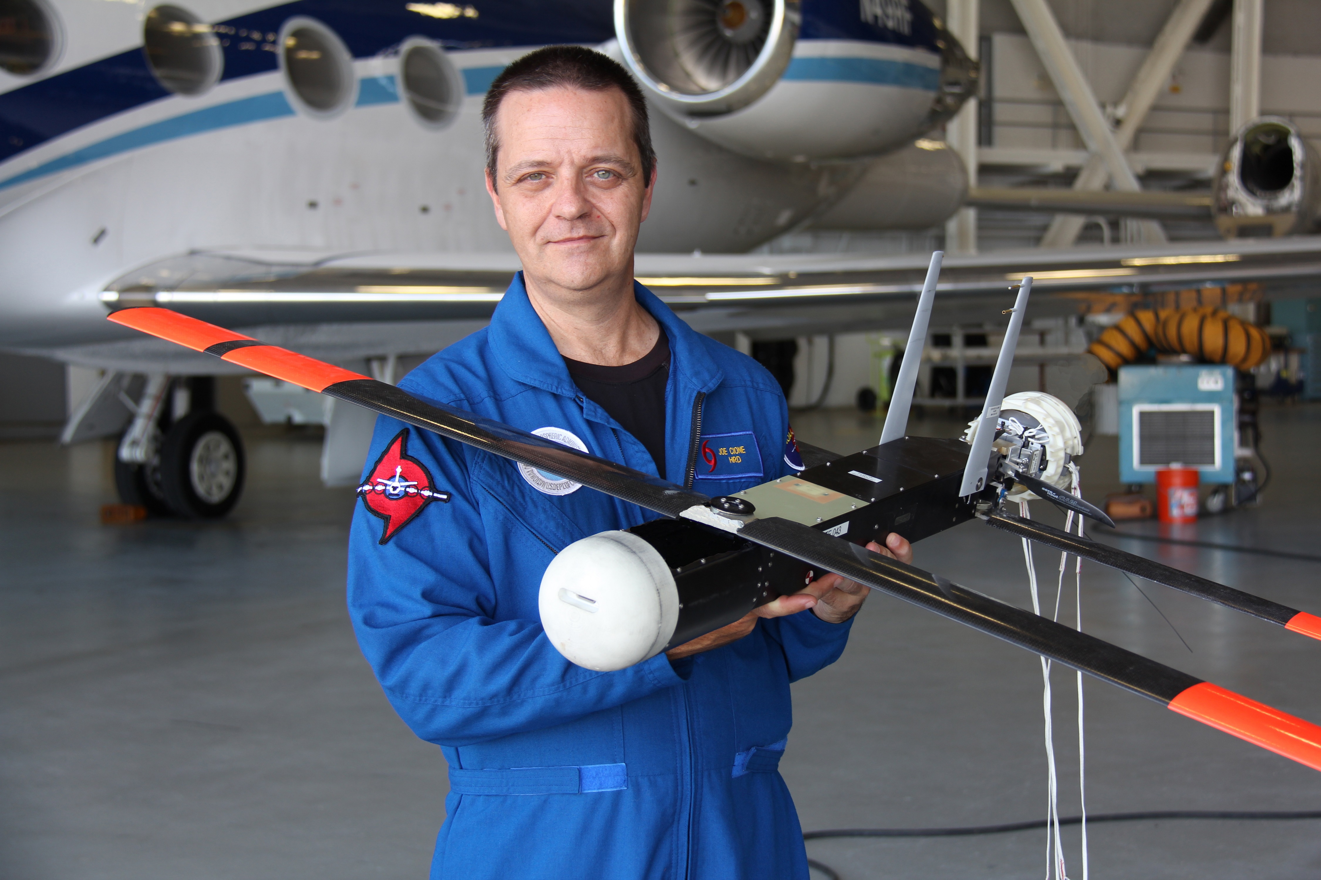 [Joe Cione holds the Coyote, a small UAS that has flown in three hurricanes. Credit: Joe Cione/NOAA AOML]
"With the drone, we can get direct measurements of these processes for the first time," Bryan said. "These data are crucial to help us configure our models to produce better simulations and forecasts."
The new paper, "Eye of the Storm: Observing Hurricanes with a Small Unmanned Aircraft System," has been accepted for publication in the Bulletin of the American Meteorological Society and is available online.
[Joe Cione holds the Coyote, a small UAS that has flown in three hurricanes. Credit: Joe Cione/NOAA AOML]
"With the drone, we can get direct measurements of these processes for the first time," Bryan said. "These data are crucial to help us configure our models to produce better simulations and forecasts."
The new paper, "Eye of the Storm: Observing Hurricanes with a Small Unmanned Aircraft System," has been accepted for publication in the Bulletin of the American Meteorological Society and is available online.
[NOAA scientist Joe Cione, lead author of a new paper on using disposable drones for hurricane observations, holds a Coyote drone in front of a NOAA P-3 "hurricane hunter" research aircraft at McDill Air Force Base in Tampa, Fla. Image courtesy of NOAA.]
"We have an instrument to collect data that we've never been able to collect before," said NCAR scientist George Bryan, a co-author of the new paper. "This is a new frontier in measuring the atmosphere."
The observations will enable scientists to determine the extent to which the gusts shift and fluctuate, which can have significant implications for hurricane behavior as well as the potential for damage once the storm moves onshore.
Bryan said the drone's measurements may also help answer a longstanding question about the interplay of hurricane winds and the ocean surface. Strong winds typically whip up ocean waves, which then exert a drag on the winds that can slow them down. Some evidence, however, indicates that hurricane-force winds cause waves to break in a way that would not exert such a drag, as well as stirring up so much froth that the water surface essentially has a lubricating effect.
[Joe Cione holds the Coyote, a small UAS that has flown in three hurricanes. Credit: Joe Cione/NOAA AOML]
"With the drone, we can get direct measurements of these processes for the first time," Bryan said. "These data are crucial to help us configure our models to produce better simulations and forecasts."
The new paper, "Eye of the Storm: Observing Hurricanes with a Small Unmanned Aircraft System," has been accepted for publication in the Bulletin of the American Meteorological Society and is available online.All Weather News
More
Catastrophic Flooding in the Texas Hill Country
Multiple Flash Flood Emergencies were issued
5 Jul 2025 2:00 PM

Tropical Storm Chantal Forms This Morning
Tropical Storm Chantal has formed, with winds
5 Jul 2025 12:10 PM

Severe Storms in the Midwest Continue To Spoil the Holiday Weekend
NORTHERN PLAINS - A frontal system continues
5 Jul 2025 8:30 AM


Near Seasonal Temperatures for Many Come July 4th!
AAA is expecting over 70 million travelers to
4 Jul 2025 10:15 AM


Northwest Heat Met With Thunderstorm Risk
NORTHWEST - Today, portions of Montana are un
3 Jul 2025 12:00 AM