Dumpster Towed Through Louisville Floodwater

Special Stories
26 Feb 2018 11:30 AM
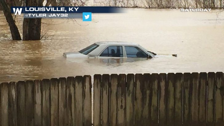
The waterfront in Louisville, Kentucky, remained underwater on Monday, February 26, as the Ohio River was expected to crest in the afternoon.
Despite that expectation, however, the river was forecast to remain at moderate flooding levels until Tuesday night, the National Weather Service said.
https://twitter.com/NWSLouisville/status/968168755929993216
Heavy rain, including nearly three inches at Louisville airport on Saturday triggered the flooding. A crest of 36.1 feet would be the ninth-highest crest for the Ohio River in Louisville.
This video shows a dumpster being towed in the floodwater in Louisville’s waterfront area.
https://youtu.be/dOKrsWZ2w7g
Heavy rain inundated a large area from the Gulf of Mexico to the Great Lakes over the past week. Cities all along the Ohio River—Pittsburgh, Cincinnati, Louisville, Evansville—were plagued with widespread flooding, as were many other areas throughout the eastern United States.
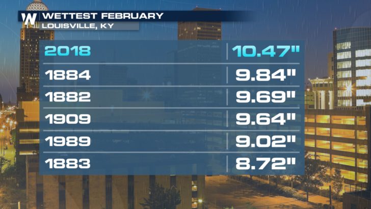
 In fact, it was so rainy in Louisville, Kentucky that February 2018 is now the wettest February in recorded history. Records began in Louisville in 1871. A total of 10.47 inches of rain fell (as of February 25th). This total surpassed the previous record of 9.84 inches that stood for 134 years!
 For more on Louisville's record setter, head here:
https://media.weathernationtv.com/news/wettest-february-record-louisville/
For your local forecast, click here.
For more on Louisville's record setter, head here:
https://media.weathernationtv.com/news/wettest-february-record-louisville/
For your local forecast, click here.
In fact, it was so rainy in Louisville, Kentucky that February 2018 is now the wettest February in recorded history. Records began in Louisville in 1871. A total of 10.47 inches of rain fell (as of February 25th). This total surpassed the previous record of 9.84 inches that stood for 134 years!
For more on Louisville's record setter, head here:
https://media.weathernationtv.com/news/wettest-february-record-louisville/
For your local forecast, click here.
All Weather News
More
Severe Chances Return for the Midwest The Next Few Days
The upcoming stretch of hot temperatures will
25 Jul 2026 2:00 AM

Tropics: Fausto Heads to Hawaii; Genevieve Has Formed and Could Become a Major Hurricane
Atlantic BasinBertha has dissipated after mov
25 Jul 2026 1:50 AM

Southeast Flood Risk Lingers Near Stalled Front
A stalled boundary over the Southeast will ke
25 Jul 2026 1:50 AM

Weekend Heat For the Western and Central United States
Are you over the summer heat yet? Well, more
25 Jul 2026 1:40 AM

Hot & Smoky w/ a Chance of Lightning
Conditions have been really dry out west. We'
24 Jul 2026 11:15 AM

Another Round of Storms Targets the Northeast
Tuesday brought severe weather again across p
23 Jul 2026 1:15 AM

Another Round of Severe Weather for the Upper Midwest and Great Lakes
The upper-level low train continues to keep t
21 Jul 2026 1:45 AM