Eleven Confirmed Tornadoes in the South - Count Likely to Increase

It has been quite the weekend of severe weather in the South, and sadly, these storms have turned deadly. We had multiple, significant tornadoes and tornado warnings starting Friday when there was a MODERATE risk through Mississippi, then again on Sunday with another MODERATE risk in Alabama. Storm surveys are still being conducted but we wanted to round up some of the most notable tornadoes so far.
Friday's Storms
Storm surveys are still being conducted, but across Mississippi, Alabama and Tennessee, there were 11 confirmed tornadoes on Friday alone, 3 of which were EF-3 or greater.
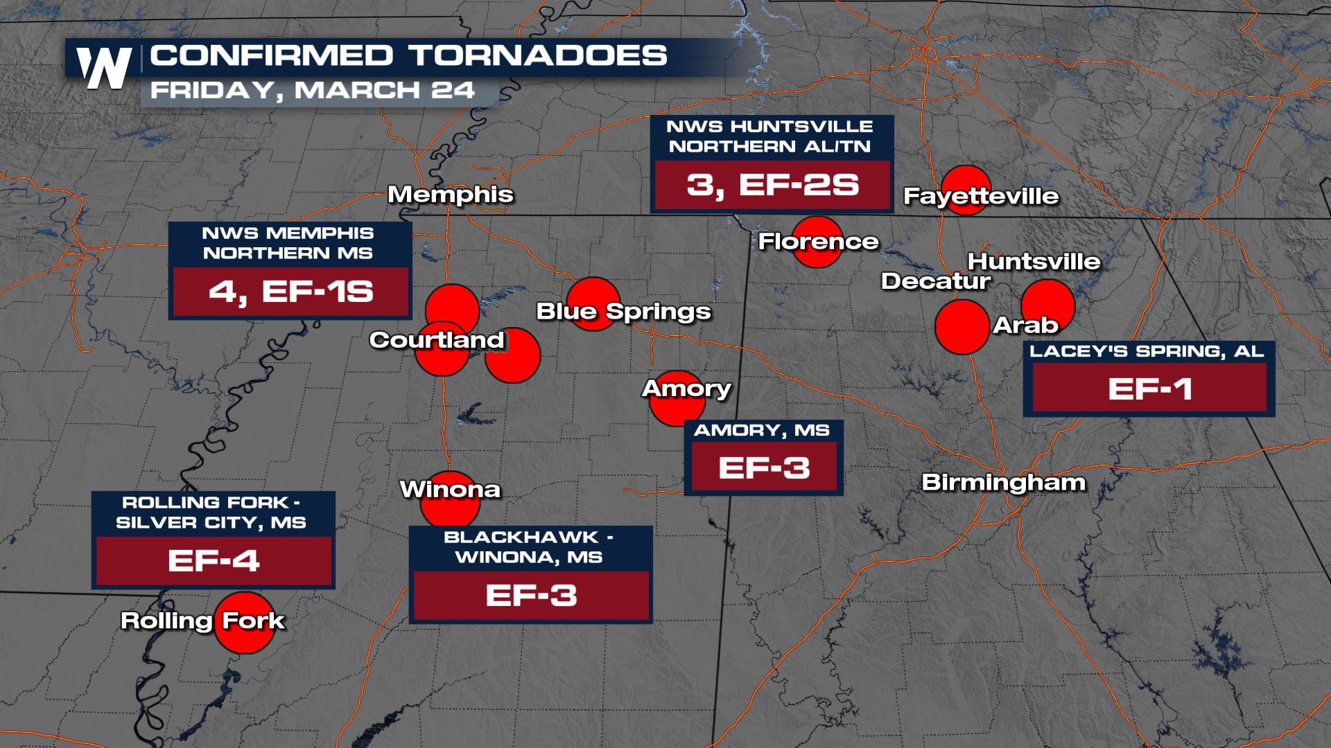
The Rolling Fork - Silver Spring tornado has been preliminarily rated an EF-4 by the National Weather Service Office in Jackson, MS. The team continues to comb through damage and data and will release further information on storm length, track and strength in the next few days. This storm is responsible for over 20 deaths as it leveled the town of Rolling Fork, tossing semi trucks like toys. The first tornado emergency of the night started at around 8 PM CT producing a tornado debris signature the size of the city of Rolling Fork. A tornado emergency is a higher level of a tornado warning, and used when there is a confirmed tornado on the ground that is known to have caused or will cause catastrophic damage.
The same cell then tracked across the state of Mississippi, with each extension of the tornado warning another tornado emergency for towns and cities in the path. When the storm reached northeast Mississippi south of Tupelo, the city of Amory took a direct hit from the tornado. While it moved across the state it "cycled" or lifted before reforming and dropping another tornado. There was a very clear "debris" signature on radar at the time the storm moved through Amory and then continued into northwest Alabama before the tornado dissipated north of Hamilton, AL. Below is a scan of the velocity as the storm moved through - the blinking pink and purple boxes are confirmed tornado warnings, meaning the storm had been observed and known to be on the ground. You can see the bright red and orange reflectivity returns on the radar right next to each other, signally how immensely strong this tornado was.
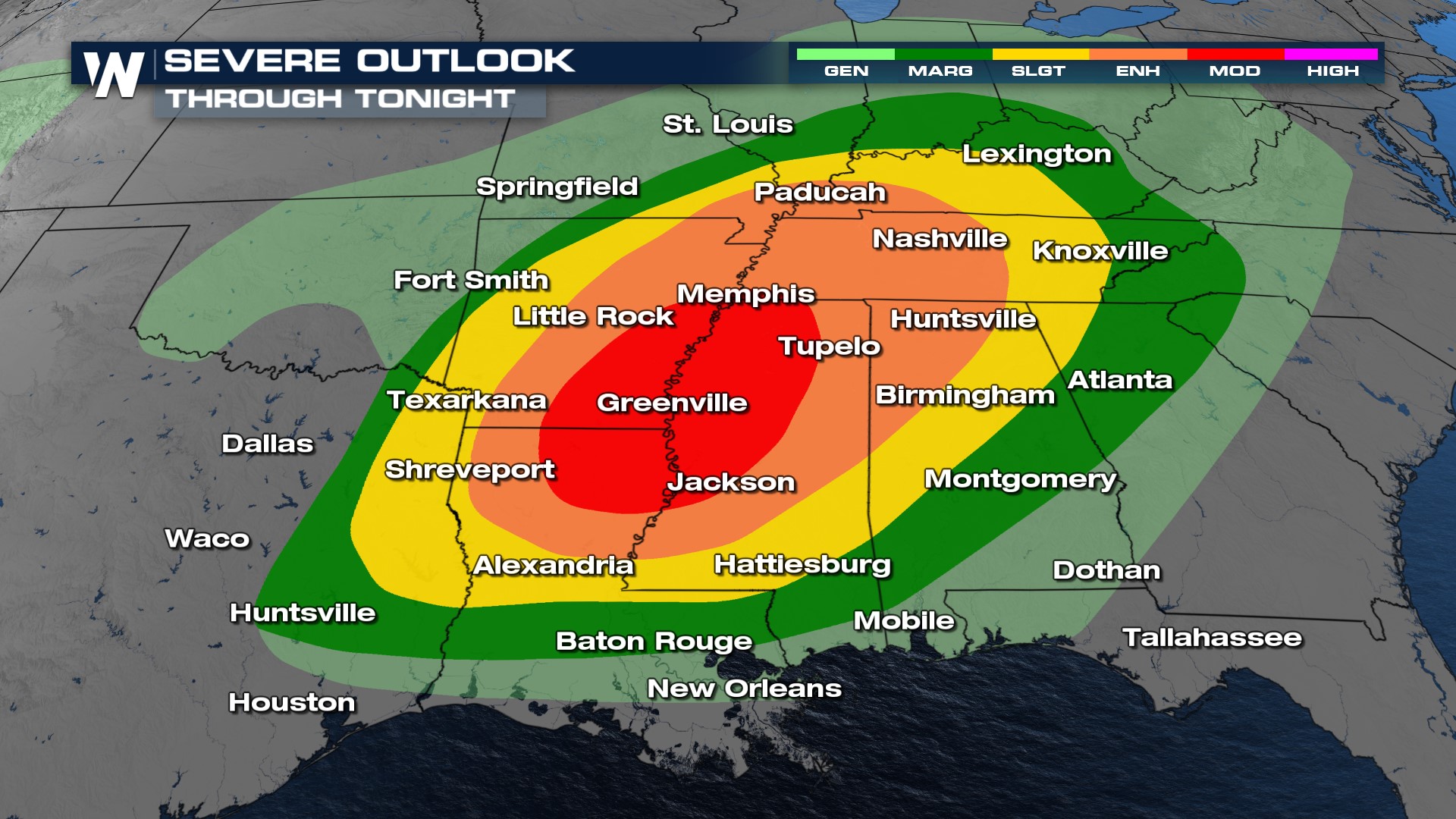
The Storm Prediction Center issued a MODERATE (level 4 out of 5) risk for the day on Friday across the Mississippi delta. In addition to the risk of numerous tornadoes, the SPC was concerned about several strong tornadoes (brown region below) that may be long-lived, or on the ground for an extended period. EF-2-strength tornadoes have winds higher than 110 mph.
 Sunday Storms
Yet another MODERATE risk was issued Sunday across the Deep South as more storms developed and contained the large hail and damaging wind threat. Sadly, we saw strong tornadoes as well, this time in Georgia, when West Point, GA (north of Columbus along the AL/GA border) was hit early Sunday morning. The storm has not yet been rated as the area has seen numerous rounds of storms since Sunday.
Stay with WeatherNation for the latest on the severe weather and storm surveys as they happen.


