Flash Flood Risk Continues Across the Midsouth
Special Stories
27 Mar 2021 7:10 PM
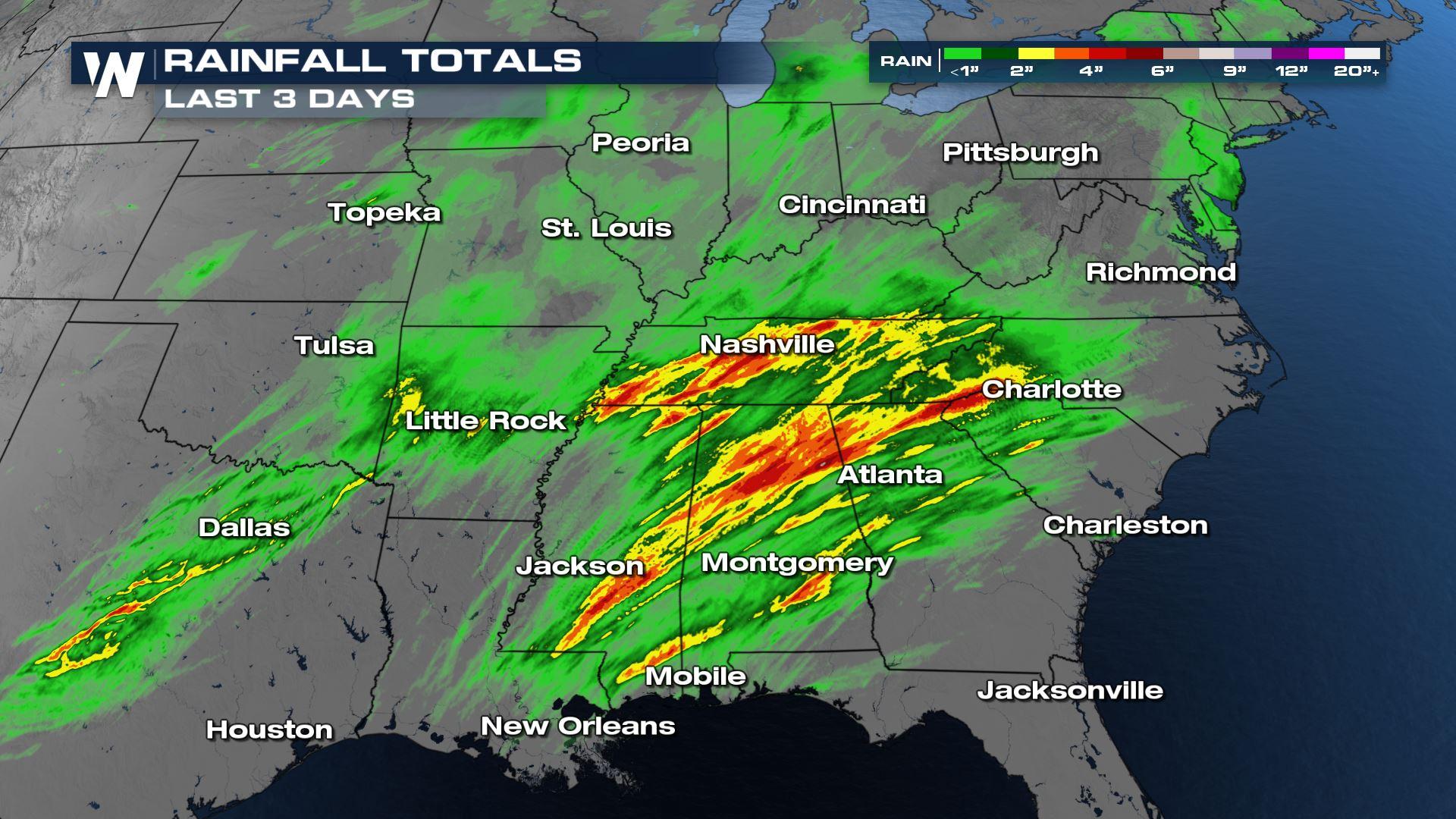
The ground is already saturated across the Mississippi and Tennessee Valleys but more rain is on the way this weekend. The additional showers could lead to flash flooding that quickly develops as runoff increases due to rain earlier this week. Rain totals from Wednesday through Saturday morning have been impressive (image above) thanks to a system that brought numerous tornadoes to the Deep South on Thursday. Another system is now ready to move across the region towards the East Coast, with a risk for severe storms both Saturday and Sunday.
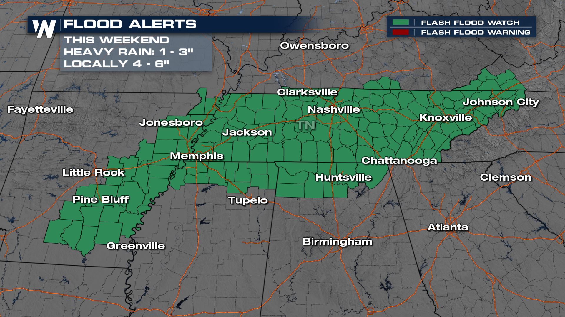 Flash flood watches have been issued from Arkansas through Western Virginia. These are in effect through Sunday morning on the western side and through Sunday evening to the east.
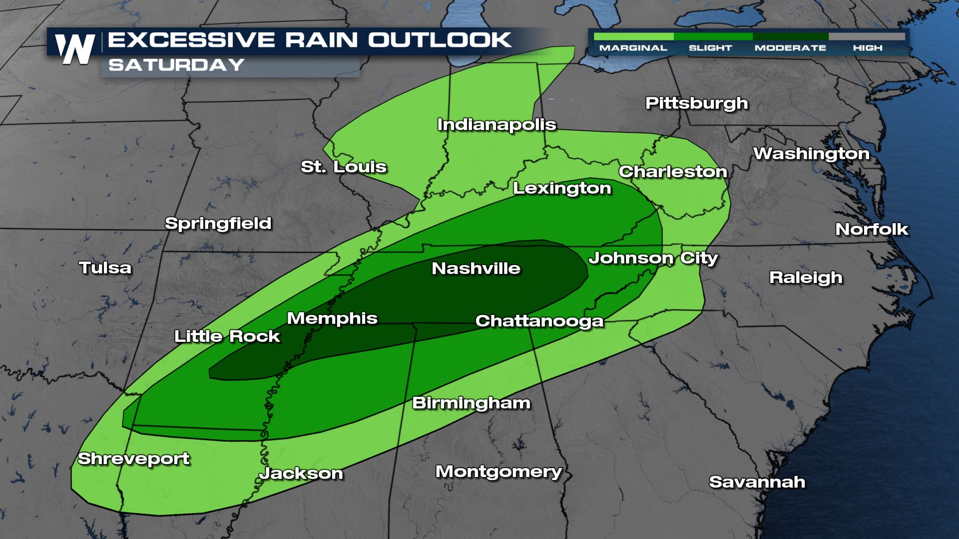 The Weather Prediction Center (WPC) has issued a moderate risk for excessive rainfall on Saturday for areas in dark green from Arkansas through Eastern Tennessee. These locations are the most likely to experience flash flooding in the heavy downpours to come. A marginal risk (lightest green) is in place across a wide area on Saturday from the Arklatex into the Great Lakes, for isolated flash flooding potential.
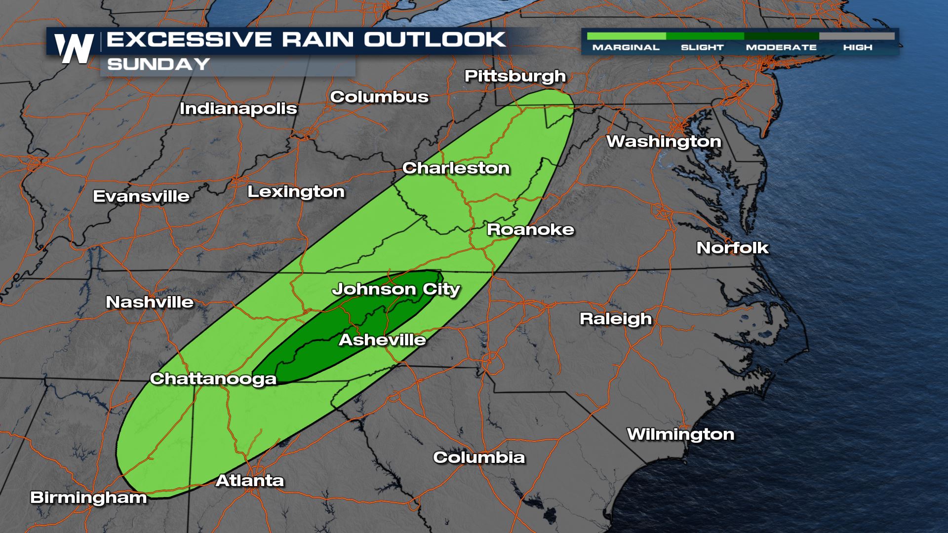 On Sunday, a line of strong thunderstorms is expected to move out of the Tennessee Valley into the Central and Southern Appalachians where heavy rain could accumulate between 1-3 inches through around midday. There is a marginal risk for excessive for the areas highlighted above, which usually indicates an isolated risk for flash flooding.
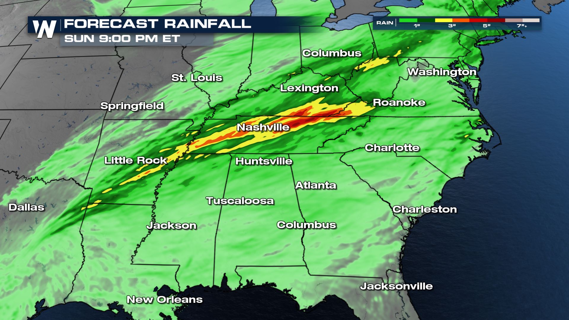 Forecast rain totals are in the 2-6 inch range where multiple thunderstorms are expected to develop Saturday into Sunday. The greatest accumulations are expected from the Arklatex through Western Virginia.
Stay with WeatherNation on air for the latest information on this flooding threat. Warnings are always scrolling across the bottom of the screen.
Forecast rain totals are in the 2-6 inch range where multiple thunderstorms are expected to develop Saturday into Sunday. The greatest accumulations are expected from the Arklatex through Western Virginia.
Stay with WeatherNation on air for the latest information on this flooding threat. Warnings are always scrolling across the bottom of the screen.
Flash flood watches have been issued from Arkansas through Western Virginia. These are in effect through Sunday morning on the western side and through Sunday evening to the east.
The Weather Prediction Center (WPC) has issued a moderate risk for excessive rainfall on Saturday for areas in dark green from Arkansas through Eastern Tennessee. These locations are the most likely to experience flash flooding in the heavy downpours to come. A marginal risk (lightest green) is in place across a wide area on Saturday from the Arklatex into the Great Lakes, for isolated flash flooding potential.
On Sunday, a line of strong thunderstorms is expected to move out of the Tennessee Valley into the Central and Southern Appalachians where heavy rain could accumulate between 1-3 inches through around midday. There is a marginal risk for excessive for the areas highlighted above, which usually indicates an isolated risk for flash flooding.
Forecast rain totals are in the 2-6 inch range where multiple thunderstorms are expected to develop Saturday into Sunday. The greatest accumulations are expected from the Arklatex through Western Virginia.
Stay with WeatherNation on air for the latest information on this flooding threat. Warnings are always scrolling across the bottom of the screen.All Weather News
More
Wildfire Outbreak in the Pacific Northwest
SPOKANE, WA - On Saturday, August 1st, the Ol
3 Aug 2026 1:55 AM

More Storms for the East Through Monday
A low-pressure system that moved through the
3 Aug 2026 1:50 AM


After Reaching Category 5, Genevieve Weakens in the Pacific
PacificGenevieve formed last Friday south of
3 Aug 2026 12:30 AM

Flooding, Severe Storms Target the Midwest Again
After an active week of storms across the nor
1 Aug 2026 1:40 AM

Flooding Risk Increases as Heavy Rain Targets the Tri-State Area
Tuesday, heavy rainfall moved across the Nort
30 Jul 2026 12:25 AM

Severe Weather: Energy From the Midwest Now in the Southeast
UPPER MIDWEST - Through Monday, dangerous tor
29 Jul 2026 10:30 PM