In Florida, A Sea Breeze Usually Leads To Thunderstorms
Special Stories
13 Jul 2018 5:14 PM
When you think of a sea breeze along the coast, it usually conjures up images of gentle winds coming onshore. Perfect conditions for kite flying or perhaps a filling the sails of a schooner zipping along the coast. But during the summer in Florida, a sea breeze often leads to afternoon showers and thunderstorms over the interior sections of the peninsula. But why? And how does it all work?
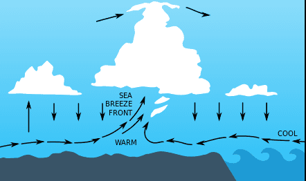
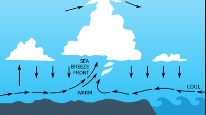
The entire process begins as soon as the sun rises. Very slowly, the sun begins to heat up the land surface. As we know, hot air rises. As the air over central Florida rises, cooler air over the Atlantic Ocean moves in from east to west to replace the rising pocket of air near the surface. This is the Atlantic sea breeze. At the same time, the exact same thing is happening along the west coast of Florida. Air over the Gulf of Mexico is rushing in from the west to east to replace the rising air. The image below depicts the sea breeze forming over the east coast of Florida.
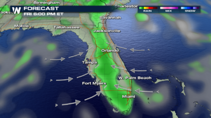
 During the afternoon hours, the sea breeze from the Atlantic, and the sea breeze from the Gulf of Mexico, eventually run into each other right over the center of Florida. When two air masses from opposite directions collide, it forces air upwards. This is called a convergence zone. The converging air masses contain water vapor collected from the Atlantic and the Gulf. As the air rises, it cools, and water vapor condenses into water droplets, forming clouds, and eventually showers and thunderstorms. This is depicted in the image below. The arrows represent the moisture laden air from the Atlantic and the Gulf, moving towards each other. The green area is the rain, forecasted to fall over central Florida. Notice the north-south orientation of the rain band. Also notice that there is no organized rain band over the panhandle of Florida. That's because showers and storms there will be more scattered in nature. There is no convergence zone. There will be only one sea breeze moving northward, from the Gulf over land.
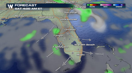
 During the evening and overnight hours, the exact opposite process happens. The land over Florida cools faster than the warm ocean waters, and a land breeze forms. The winds blow from Florida out to sea. The showers and storms collapse, and the rain event is over, until the whole sea breeze process sets-up again the next afternoon.
 For WeatherNation: Meteorologist Matt Monroe
During the afternoon hours, the sea breeze from the Atlantic, and the sea breeze from the Gulf of Mexico, eventually run into each other right over the center of Florida. When two air masses from opposite directions collide, it forces air upwards. This is called a convergence zone. The converging air masses contain water vapor collected from the Atlantic and the Gulf. As the air rises, it cools, and water vapor condenses into water droplets, forming clouds, and eventually showers and thunderstorms. This is depicted in the image below. The arrows represent the moisture laden air from the Atlantic and the Gulf, moving towards each other. The green area is the rain, forecasted to fall over central Florida. Notice the north-south orientation of the rain band. Also notice that there is no organized rain band over the panhandle of Florida. That's because showers and storms there will be more scattered in nature. There is no convergence zone. There will be only one sea breeze moving northward, from the Gulf over land.
During the evening and overnight hours, the exact opposite process happens. The land over Florida cools faster than the warm ocean waters, and a land breeze forms. The winds blow from Florida out to sea. The showers and storms collapse, and the rain event is over, until the whole sea breeze process sets-up again the next afternoon.
For WeatherNation: Meteorologist Matt MonroeAll Weather News
More
Wildfire Outbreak in the Pacific Northwest
SPOKANE, WA - On Saturday, August 1st, the Ol
3 Aug 2026 1:55 AM

More Storms for the East Through Monday
A low-pressure system that moved through the
3 Aug 2026 1:50 AM


After Reaching Category 5, Genevieve Weakens in the Pacific
PacificGenevieve formed last Friday south of
3 Aug 2026 12:30 AM

Flooding, Severe Storms Target the Midwest Again
After an active week of storms across the nor
1 Aug 2026 1:40 AM

Flooding Risk Increases as Heavy Rain Targets the Tri-State Area
Tuesday, heavy rainfall moved across the Nort
30 Jul 2026 12:25 AM

Severe Weather: Energy From the Midwest Now in the Southeast
UPPER MIDWEST - Through Monday, dangerous tor
29 Jul 2026 10:30 PM