Great Satellite Views of Winter Nor'easter
Special Stories
5 Jan 2018 9:44 AM
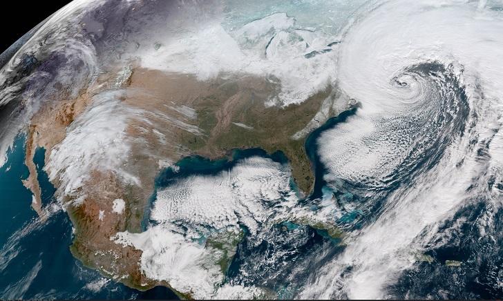
The National Oceanic and Atmospheric Administration (NOAA) GOES-16 satellites have been capturing very telling imagery of the Nor'easter deepening off the East coast of the United States the last few days. The powerful storm has battered the region with heavy snow, coastal flooding, and strong winds from Florida to Maine.
The Geocolor image above is a multispectral product composed of True Color (using a simulated green component) during the daytime, and an Infrared product that uses bands 7 and 13 at night. During the day, the imagery looks approximately as it would appear when viewed with human eyes from space.
https://twitter.com/NOAASatellites/status/948947460088573952
You may have heard the Nor'easter called a "bomb cyclone". Meteorologists say that a storm undergoes "bombogenesis" when it rapidly intensifies over a short period. More precisely, it's a mid-latitude cyclone that sees its central pressure drop 24 millibars or more within 24 hours. Storms like this typically bring heavy precipitation, strong winds, and coastal storm surge and are common along the East Coast during the winter months.
https://twitter.com/NOAASatellites/status/949033037181878273
The Geostationary Operational Environmental Satellite (GOES) – R Series is a collaborative development and acquisition effort between NOAA and NASA. The GOES-16 (GOES-East) satellite, the first of the series, provides continuous imagery and atmospheric measurements of Earth’s western hemisphere and space weather monitoring.
https://twitter.com/NOAASatellites/status/949277725432451077
For WeatherNation: Meteorologist Mace Michaels
All Weather News
More

Flooding, Severe Storms Target the Midwest Again
After an active week of storms across the nor
1 Aug 2026 1:40 AM


After Reaching Category 5, Genevieve Weakens in the Pacific
PacificFausto is now a post-tropical cyclone.
31 Jul 2026 1:30 AM

Flooding Risk Increases as Heavy Rain Targets the Tri-State Area
Tuesday, heavy rainfall moved across the Nort
30 Jul 2026 12:25 AM

Severe Weather: Energy From the Midwest Now in the Southeast
UPPER MIDWEST - Through Monday, dangerous tor
29 Jul 2026 10:30 PM