Big Temperature Swings with the Active Weather Weekend

news image
Top Stories
29 Mar 2025 9:20 AM

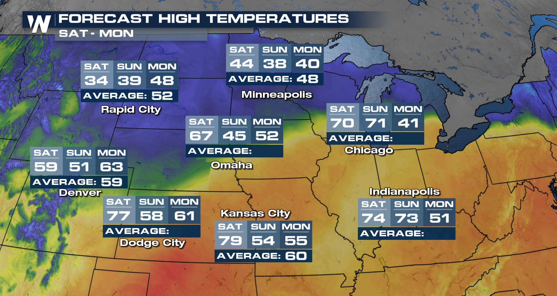
A strong area of high pressure has built east into the Plains and Upper Midwest, which means warm-to-hot temperatures have been felt. Another round of records was set today across much of the country on Friday.

While the heat was on Friday, temperatures are expected to cool quickly as low pressure wraps air in from the north.

Check out all the colder air moving in behind the cold front.

As a gathering system from the west pulls in cooler air, temperatures will drop tremendously! By Saturday, Rapid City will see high temperatures in the low 30s. In Sioux Falls, we'll go from temperatures That were in the low 80s on Friday to a high of 42° to start the weekend!

We have more on the upcoming cooldown across the Plains in your Central Regional Forecast, every :30 past the hour!

All Weather News
More
Heavy Rain and Snow Moves Into California Next Week

Heavy Rain and Snow Moves Into California Next Week

CALIFORNIA - Atmospheric moisture is being di

20 Dec 2025 11:00 AM
ATMOSPHERIC RIVER: Winds Topping 100 MPH In the Northwest

ATMOSPHERIC RIVER: Winds Topping 100 MPH In the Northwest

WEST - A river of moisture has been directed

20 Dec 2025 1:10 AM
Record Warmth Continues

Record Warmth Continues

Unseasonably warm temperatures continue to do

20 Dec 2025 1:10 AM
End of Year Travel Expected to Break Records

End of Year Travel Expected to Break Records

As 2025 comes to an end, many people are expe

20 Dec 2025 1:00 AM
Extreme Critical Fire Risk in Colorado Friday

Extreme Critical Fire Risk in Colorado Friday

As wind intensifies once again across the Fro

19 Dec 2025 11:10 PM
Returning Back to the Freezer This Week

Returning Back to the Freezer This Week

It's been a cold start to the week for millio

19 Dec 2025 2:55 AM
Messy System Moving into the Midwest

Messy System Moving into the Midwest

NORTHERN PLAINS - A low-pressure system origi

18 Dec 2025 11:45 AM