Historic Flash Flooding from Ida Inundates the Northeast
Special Stories
2 Sep 2021 7:30 PM
Catastrophic rainfall impacted much of the Northeast Wednesday into Thursday morning due to the remnants of Hurricane Ida, in addition to numerous strong tornadoes around the Chesapeake Bay up through New Jersey.
While the damaged caused by tornadoes was intense, the flash flooding may be some of the worst seen in New York City in modern history.
https://twitter.com/NWSNewYorkNY/status/1433249873206419457
https://twitter.com/NWSNewYorkNY/status/1433244063961006080
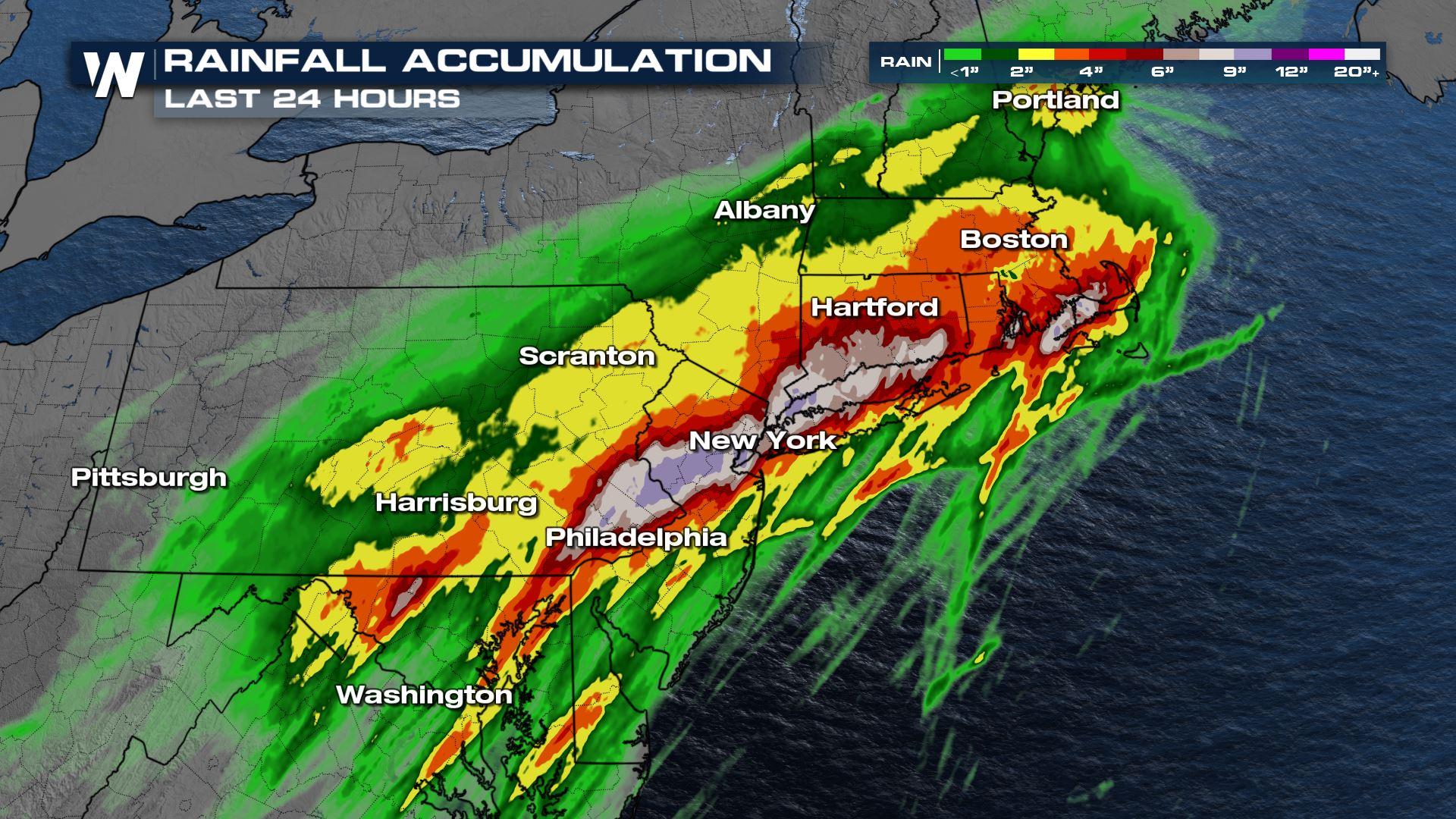
The National Weather Service in New York City issued its first ever flash flood emergency for the downtown area. Flash flood emergencies are reserved for dire and catastrophic flooding situations, which was unfortunately the case Wednesday night. Central Park recorded over 7 inches of rain with more than 3 inches of that coming down in under an hour. Residents were told to not drive into the city until after 5 AM ET Thursday.
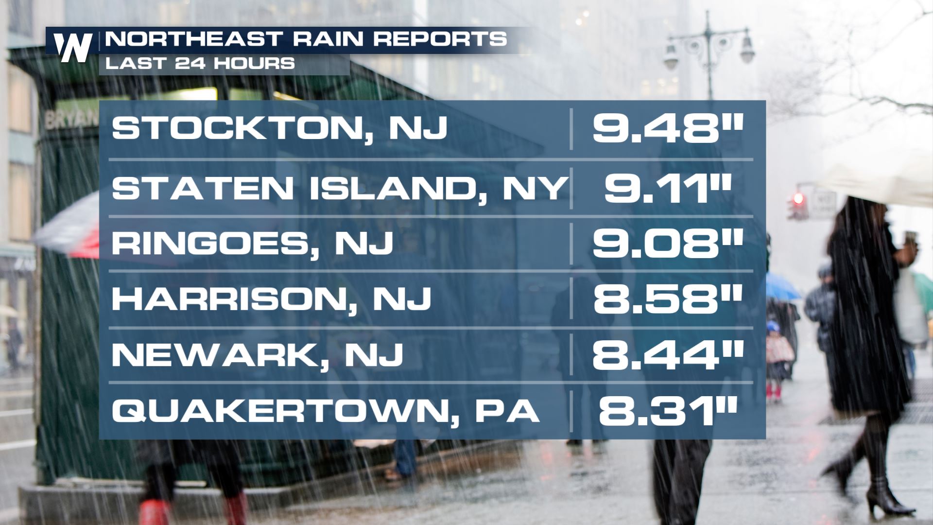
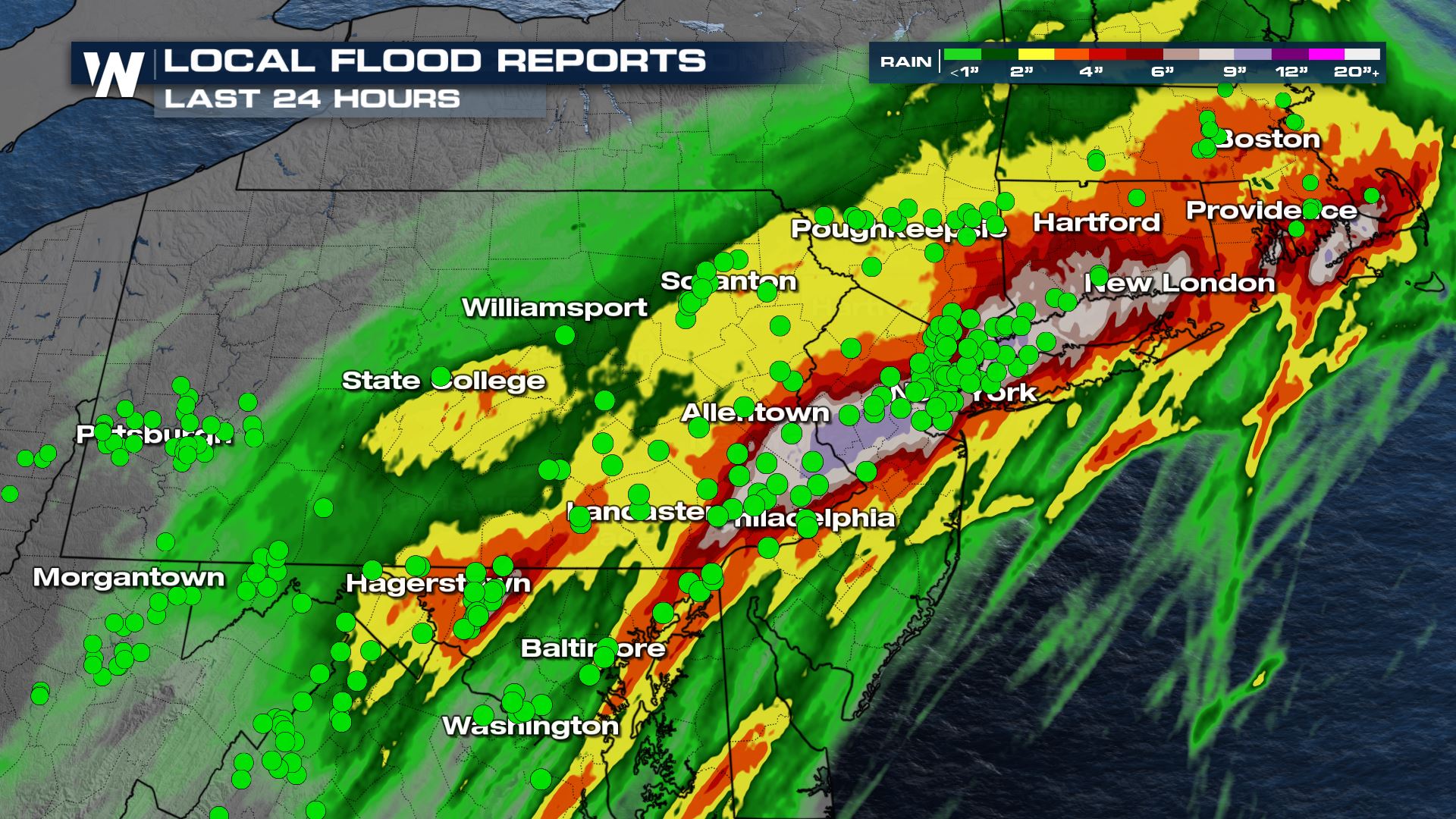 Widespread rainfall totals across the region surpassed 6 inches, while a stripe of heavy rain put down more than 9 inches in multiple locations. All of the green dots represent flood reports.
https://twitter.com/JoeEEnglish/status/1433250226329030659
Aside from numerous roads and vehicles being inundated with several feet or rain, flooding was reported in apartments as well as the subway system. This led to numerous deaths in the region.
https://twitter.com/WeatherNation/status/1433262540973395968
Fortunately all of the rainfall associated with the remnants of Ida is finished. However, water levels continue to remain on the high side. See more in our story below:
Related Story: Major Flooding Continues On Northeast Rivers
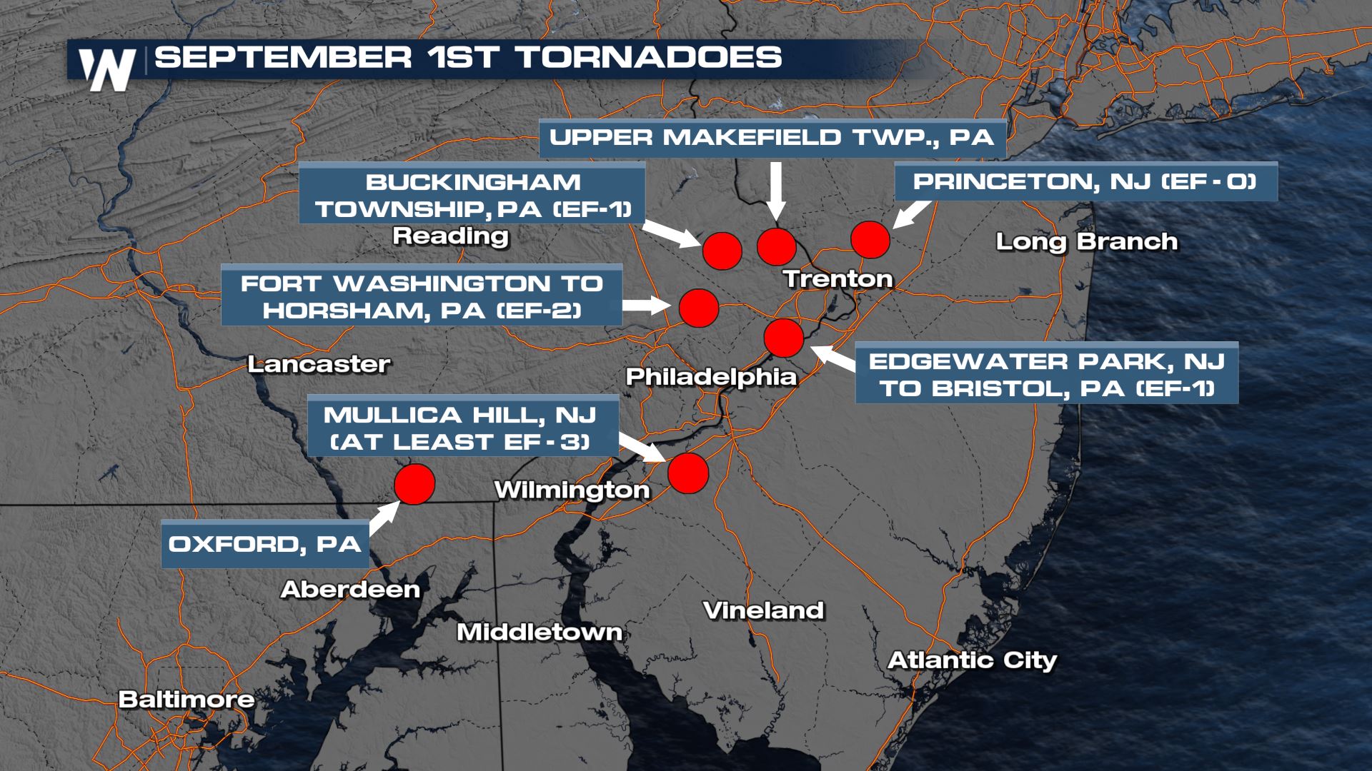
Numerous tornadoes were confirmed from this event as well. The National Weather Service in Mount Holly, NJ (responsible for the Philadelphia area forecasts) says at least 7 tornadoes touched down on Wednesday.
https://twitter.com/NWS_MountHolly/status/1433567161742553090
Widespread rainfall totals across the region surpassed 6 inches, while a stripe of heavy rain put down more than 9 inches in multiple locations. All of the green dots represent flood reports.
https://twitter.com/JoeEEnglish/status/1433250226329030659
Aside from numerous roads and vehicles being inundated with several feet or rain, flooding was reported in apartments as well as the subway system. This led to numerous deaths in the region.
https://twitter.com/WeatherNation/status/1433262540973395968
Fortunately all of the rainfall associated with the remnants of Ida is finished. However, water levels continue to remain on the high side. See more in our story below:
Related Story: Major Flooding Continues On Northeast Rivers
Numerous tornadoes were confirmed from this event as well. The National Weather Service in Mount Holly, NJ (responsible for the Philadelphia area forecasts) says at least 7 tornadoes touched down on Wednesday.
https://twitter.com/NWS_MountHolly/status/1433567161742553090
 The American Red Cross has set up multiple shelter locations around the hardest hit locations. We encourage you to seek additional information regarding the shelter location and vacancy, as well as to consider making donations to reputable organizations which will assist the impacted residents/population.
We'll continue to cover the clean up process and remnant issues behind the remnants of Ida. Tune in 10 past each hour for the latest forecast for the Eastern Reigon.
The American Red Cross has set up multiple shelter locations around the hardest hit locations. We encourage you to seek additional information regarding the shelter location and vacancy, as well as to consider making donations to reputable organizations which will assist the impacted residents/population.
We'll continue to cover the clean up process and remnant issues behind the remnants of Ida. Tune in 10 past each hour for the latest forecast for the Eastern Reigon.
Widespread rainfall totals across the region surpassed 6 inches, while a stripe of heavy rain put down more than 9 inches in multiple locations. All of the green dots represent flood reports.
https://twitter.com/JoeEEnglish/status/1433250226329030659
Aside from numerous roads and vehicles being inundated with several feet or rain, flooding was reported in apartments as well as the subway system. This led to numerous deaths in the region.
https://twitter.com/WeatherNation/status/1433262540973395968
Fortunately all of the rainfall associated with the remnants of Ida is finished. However, water levels continue to remain on the high side. See more in our story below:
Related Story: Major Flooding Continues On Northeast Rivers
Numerous tornadoes were confirmed from this event as well. The National Weather Service in Mount Holly, NJ (responsible for the Philadelphia area forecasts) says at least 7 tornadoes touched down on Wednesday.
https://twitter.com/NWS_MountHolly/status/1433567161742553090
The American Red Cross has set up multiple shelter locations around the hardest hit locations. We encourage you to seek additional information regarding the shelter location and vacancy, as well as to consider making donations to reputable organizations which will assist the impacted residents/population.
We'll continue to cover the clean up process and remnant issues behind the remnants of Ida. Tune in 10 past each hour for the latest forecast for the Eastern Reigon.All Weather News
More
More Storms for the East Through Monday
A low-pressure system that moved through the
3 Aug 2026 12:20 PM


After Reaching Category 5, Genevieve Weakens in the Pacific
PacificGenevieve formed last Friday south of
3 Aug 2026 12:30 AM

Flooding, Severe Storms Target the Midwest Again
After an active week of storms across the nor
1 Aug 2026 1:40 AM

Flooding Risk Increases as Heavy Rain Targets the Tri-State Area
Tuesday, heavy rainfall moved across the Nort
30 Jul 2026 12:25 AM

Severe Weather: Energy From the Midwest Now in the Southeast
UPPER MIDWEST - Through Monday, dangerous tor
29 Jul 2026 10:30 PM