Hurricane Chris Strengthens and Picks up Speed
Special Stories
11 Jul 2018 6:40 PM
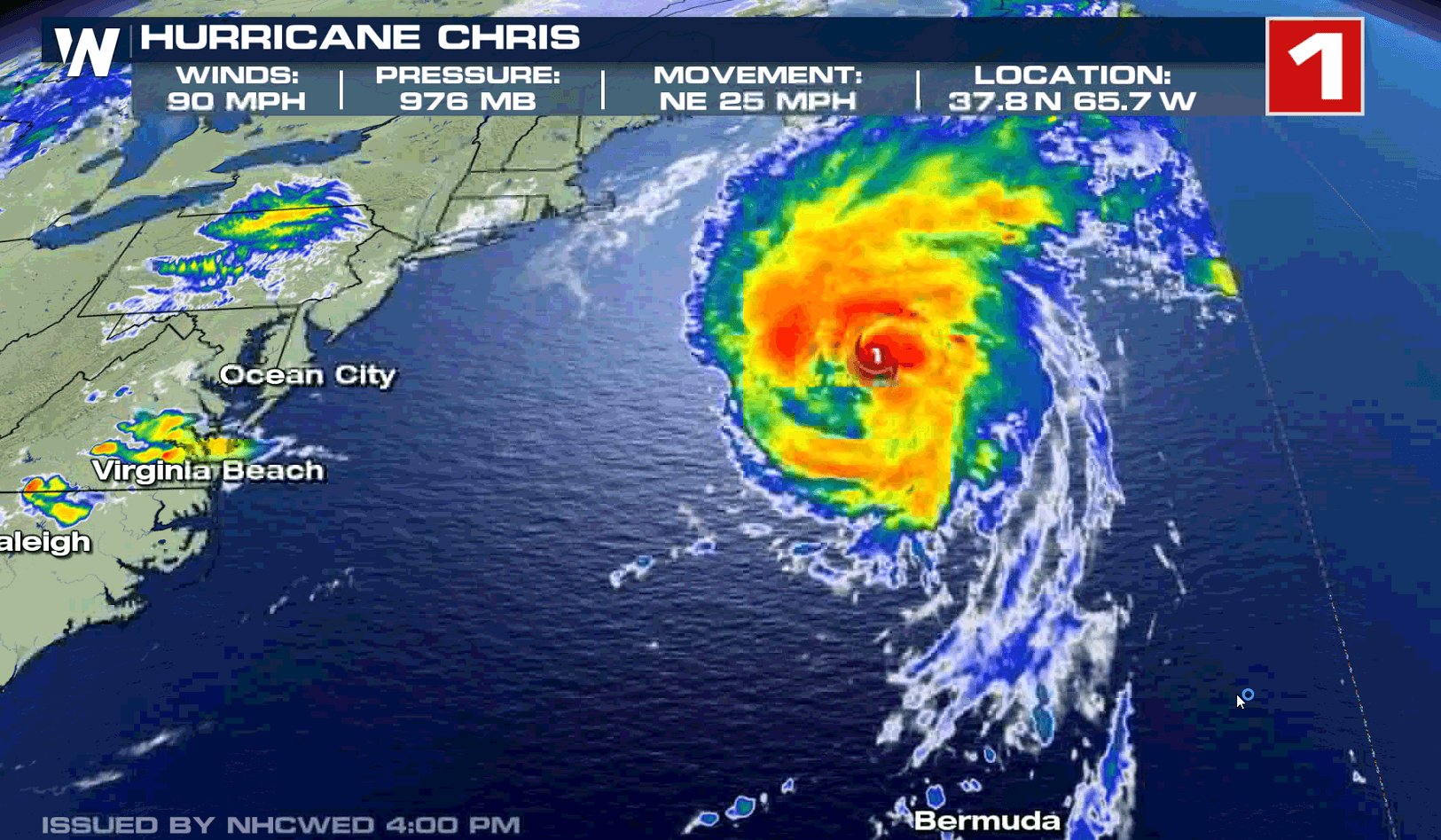
Hurricane Chris continues to strengthen in the Atlantic Ocean, about 570 east-northeast of Cape Hatteras, North Carolina. Wind speeds have increased to 90 mph and the storm is moving much faster, northeast at 25 mph.
https://twitter.com/WeatherNation/status/1017203743547318272
https://twitter.com/WeatherNation/status/1017078076260282368
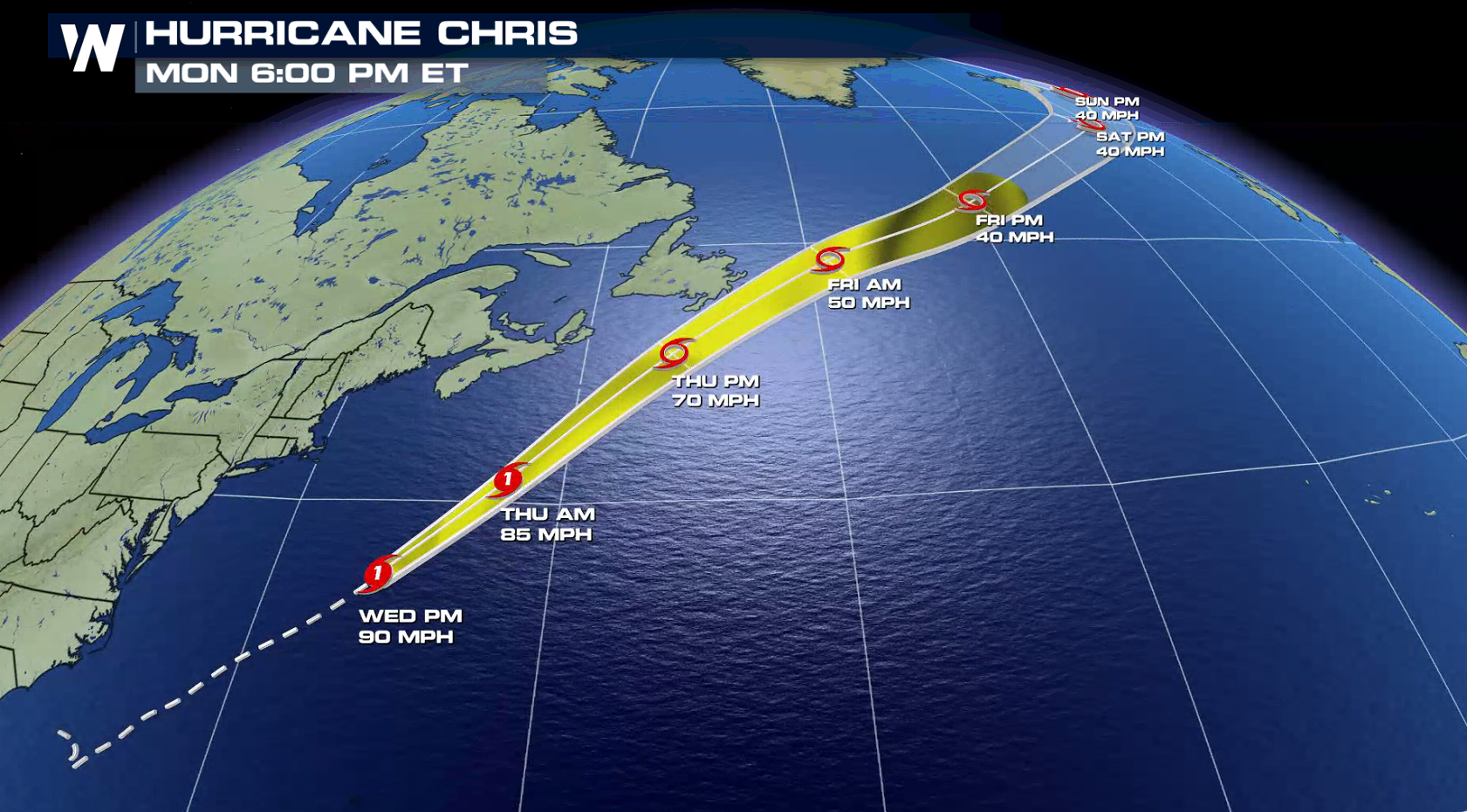
Chris will continue to pick up speed as it is swept ahead of a digging storm system moving into the Northeast. As the storm continues to move over warm Gulf Stream waters, little change in intensity is expected into Thursday. Later Friday, the storm will begin to pass over colder waters of the North Atlantic and will begin to weaken.
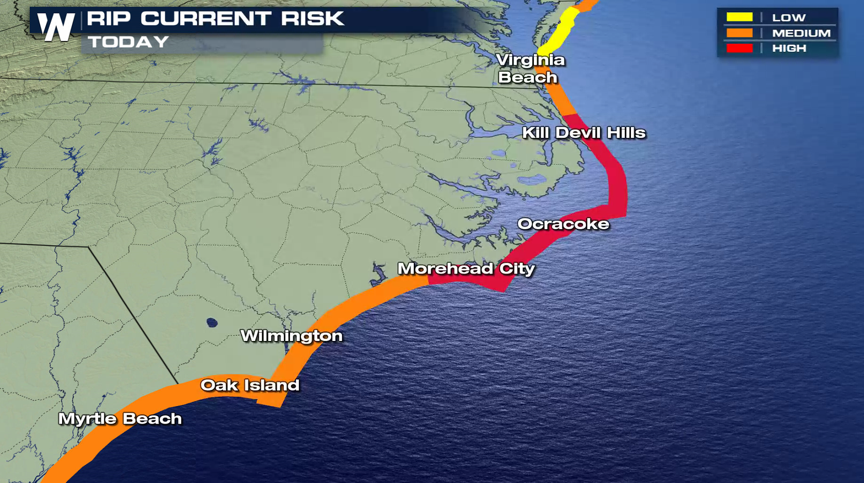
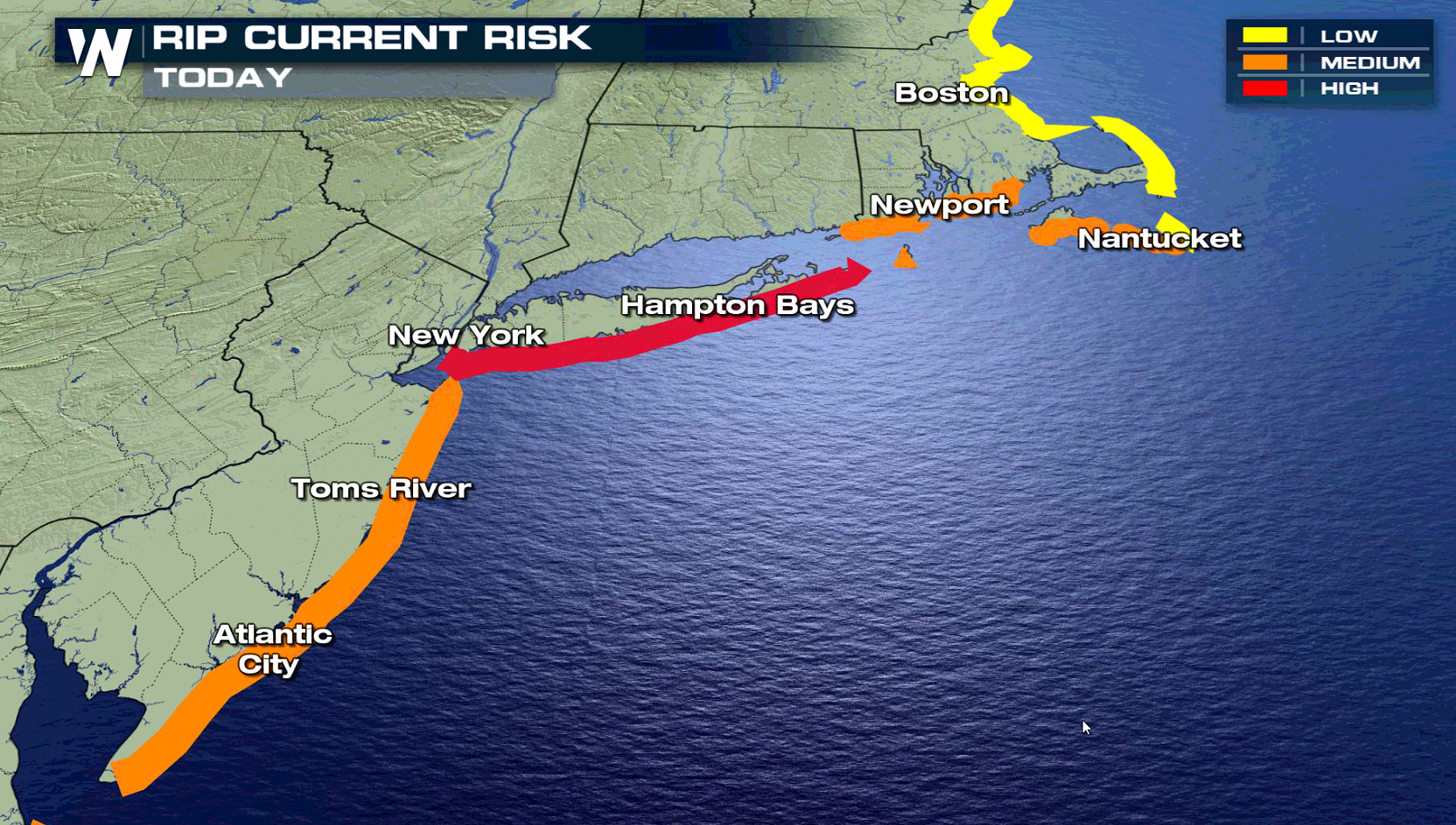
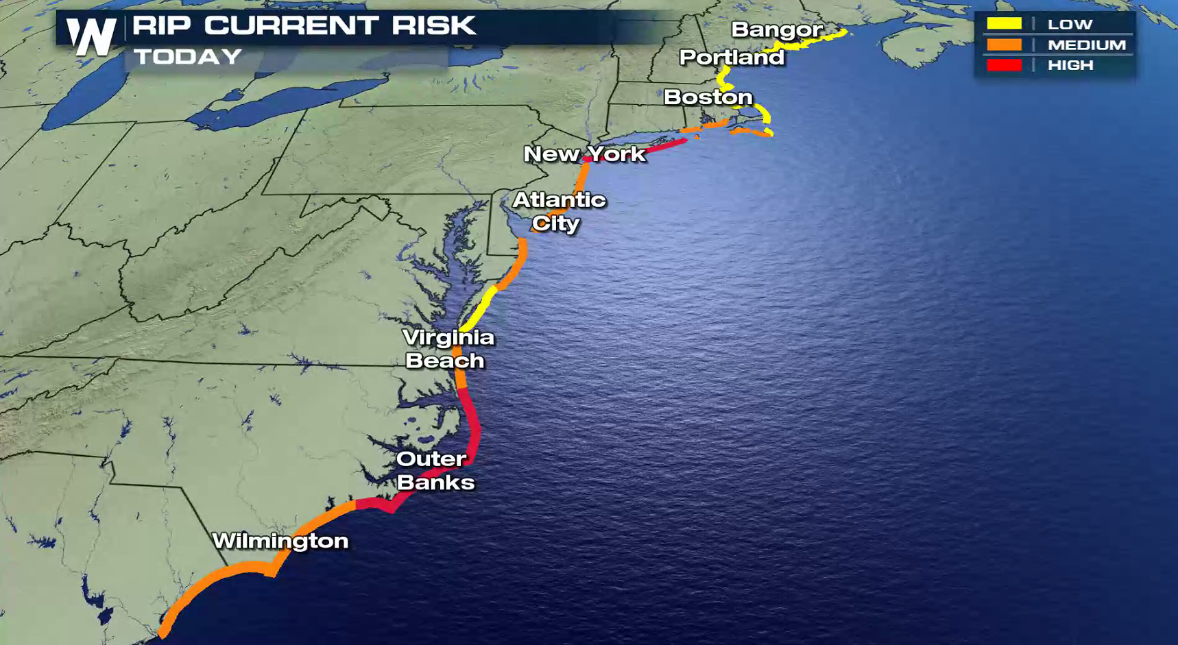
 Swells generated by Hurricane Chris are expected to affect portions of the coasts of North Carolina and the mid-Atlantic states during the next few days. These swells could cause life-threatening surf and rip current conditions. Coastal Flood Advisories have been issued along the New Jersey coast as the strong onshore flow, coupled with high tides, may produce flooding. Up to one foot of saltwater inundation
above ground level is possible in low-lying areas near shorelines and tidal waterways. Minor roadway flooding is possible for coastal locations in Monmouth County and Ocean County. Wave heights on the ocean waters off the coast are forecast to be 3 to 4 feet.
https://www.facebook.com/NWSMountHolly/posts/2020812257952162
Rip currents are powerful channels of water flowing quickly away from shore, which occur most often at low spots or breaks in sandbars and near structures such as groins, jetties, and piers. Talk to lifeguards and beach officials to learn about any surf hazards and heed their advice. Pay attention to flags and posted signs and swim in life guarded areas. If caught in a rip current, relax and float, and do not swim against the current. If able, swim in a direction following the shoreline. If unable to escape, face the
shore and call or wave for help.
Swells generated by Hurricane Chris are expected to affect portions of the coasts of North Carolina and the mid-Atlantic states during the next few days. These swells could cause life-threatening surf and rip current conditions. Coastal Flood Advisories have been issued along the New Jersey coast as the strong onshore flow, coupled with high tides, may produce flooding. Up to one foot of saltwater inundation
above ground level is possible in low-lying areas near shorelines and tidal waterways. Minor roadway flooding is possible for coastal locations in Monmouth County and Ocean County. Wave heights on the ocean waters off the coast are forecast to be 3 to 4 feet.
https://www.facebook.com/NWSMountHolly/posts/2020812257952162
Rip currents are powerful channels of water flowing quickly away from shore, which occur most often at low spots or breaks in sandbars and near structures such as groins, jetties, and piers. Talk to lifeguards and beach officials to learn about any surf hazards and heed their advice. Pay attention to flags and posted signs and swim in life guarded areas. If caught in a rip current, relax and float, and do not swim against the current. If able, swim in a direction following the shoreline. If unable to escape, face the
shore and call or wave for help.
 For WeatherNation: Meteorologist Mace Michaels
Swells generated by Hurricane Chris are expected to affect portions of the coasts of North Carolina and the mid-Atlantic states during the next few days. These swells could cause life-threatening surf and rip current conditions. Coastal Flood Advisories have been issued along the New Jersey coast as the strong onshore flow, coupled with high tides, may produce flooding. Up to one foot of saltwater inundation
above ground level is possible in low-lying areas near shorelines and tidal waterways. Minor roadway flooding is possible for coastal locations in Monmouth County and Ocean County. Wave heights on the ocean waters off the coast are forecast to be 3 to 4 feet.
https://www.facebook.com/NWSMountHolly/posts/2020812257952162
Rip currents are powerful channels of water flowing quickly away from shore, which occur most often at low spots or breaks in sandbars and near structures such as groins, jetties, and piers. Talk to lifeguards and beach officials to learn about any surf hazards and heed their advice. Pay attention to flags and posted signs and swim in life guarded areas. If caught in a rip current, relax and float, and do not swim against the current. If able, swim in a direction following the shoreline. If unable to escape, face the
shore and call or wave for help.
For WeatherNation: Meteorologist Mace MichaelsAll Weather News
More

More Storms for the East Through Monday
A low-pressure system that moved through the
3 Aug 2026 12:20 PM


After Reaching Category 5, Genevieve Weakens in the Pacific
PacificGenevieve formed last Friday south of
3 Aug 2026 12:30 AM

Flooding, Severe Storms Target the Midwest Again
After an active week of storms across the nor
1 Aug 2026 1:40 AM

Flooding Risk Increases as Heavy Rain Targets the Tri-State Area
Tuesday, heavy rainfall moved across the Nort
30 Jul 2026 12:25 AM