January El Nino Update - El Nino Watch Continues
Special Stories
11 Jan 2019 12:01 PM
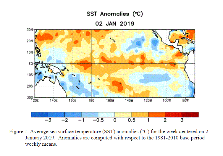
Just like last month, the surface of the tropical Pacific Ocean is nice and warm, but the atmosphere has yet to respond so an El Nino watch continues. A full El Nino pattern is still expected to form between now and Spring, but chances have been lower to 65% this month (from 90% in December).
According to the Climate Prediction Center's (CPC) latest advisory, there are "widespread above-average sea surface temperatures (SSTs) across the equatorial Pacific Ocean." Despite the above-average ocean temperatures, the overall atmosphere circulation continued to reflect neutral conditions. The late winter and early spring are the most favored months for the weather patterns to sync with the warm ocean temperatures, so there is a still a likelihood that El Nino will happen.
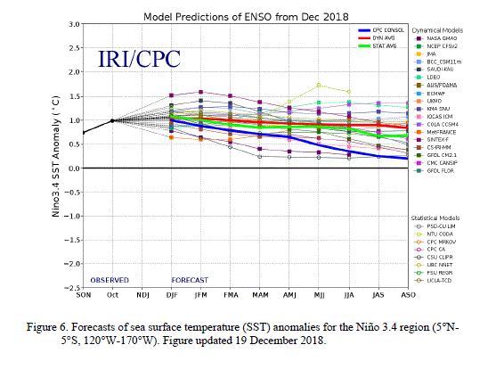
 The CPC notes that the majority of the long range climate forecast models predict a Niño3.4 index of +0.5°C or greater through at least the Northern Hemisphere into Spring. However, given the timing and that a weak event is favored, significant global impacts are not anticipated during the remainder of winter, if conditions were to form.
 For WeatherNation: Meteorologist Mace Michaels
 The CPC notes that the majority of the long range climate forecast models predict a Niño3.4 index of +0.5°C or greater through at least the Northern Hemisphere into Spring. However, given the timing and that a weak event is favored, significant global impacts are not anticipated during the remainder of winter, if conditions were to form.
 For WeatherNation: Meteorologist Mace Michaels
All Weather News
More