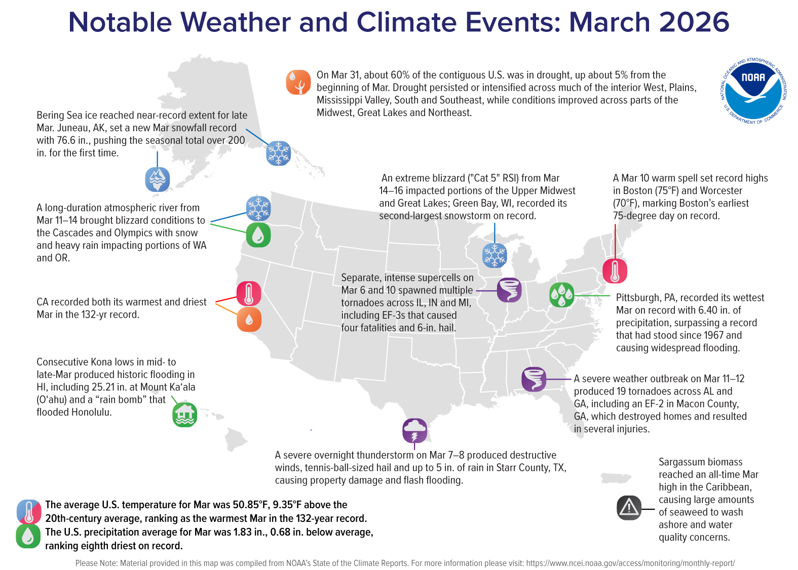
March 2026: Warmest March on Record for U.S.

SOURCE: NCEI, NOAA
Key Takeaways:
Warmest March: The contiguous U.S. (CONUS) average temperature was 9.4°F above the 20th-century average, making March 2026 the warmest March in the 132-year record.
Prolonged warmth: The April 2025–March 2026 period now stands as the warmest 12-month span ever recorded for the CONUS (since 1895).
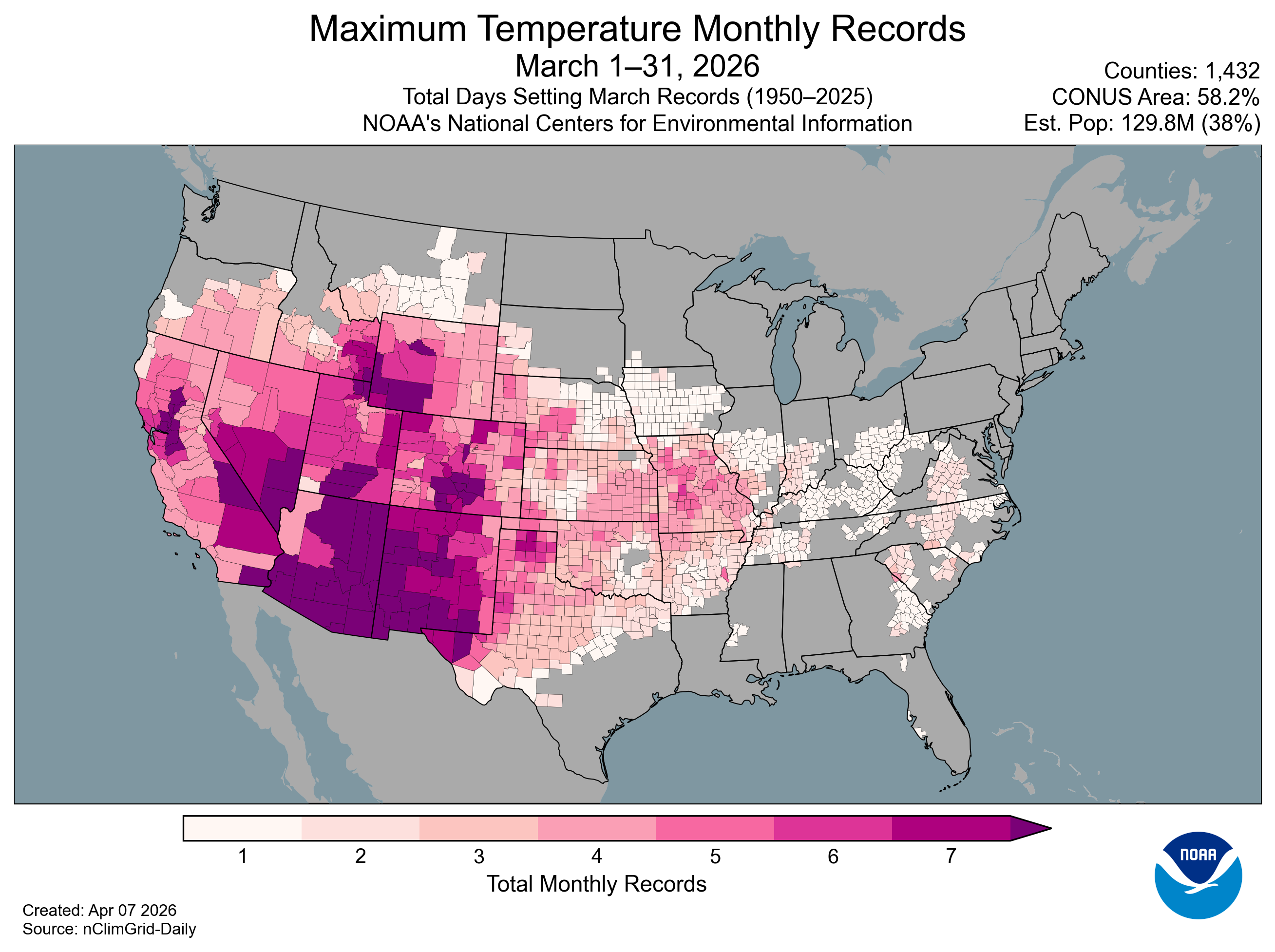
Record daily heat: 1,432 counties—over half the CONUS area and one-third of the population—observed their single warmest March day on record (1950–present).
Record-dry year to date: The January–March period was the driest on record for the CONUS—less than 70% of average—breaking the previous record set in 1910.
Notable drought footprint: Dry conditions expanded drought to nearly 60 percent of the CONUS—the largest extent of drought since November 2022.
Cold in Alaska: Alaska had its fourth-coldest March on record (since 1925) and the coldest since 2007.
Temperature
The CONUS average temperature in March was 50.85°F, 9.35°F above the 20th-century average, marking the first time any month’s average has exceeded 9°F above that baseline. Maximum daytime temperatures were especially high, averaging 11.4°F above the March average and 0.9°F above the April long-term average.
Much of the country south of the far northern tier, from the Pacific to the Atlantic, experienced much-above-average temperatures. A broad region spanning the central Pacific Coast, Great Basin, Southwest, and parts of the Rockies and southern Plains observed record warmth, highlighting the widespread extent of the month’s exceptional temperatures.
Ten states recorded their warmest March on record: Arizona, California, Colorado, Idaho, Nevada, New Mexico, Oklahoma, Texas, Utah and Wyoming. Across all of these states, average temperatures exceeded their respective April averages, with California also eclipsing its average May temperature by 0.7°F.
At the county level, more than 500 counties—covering over one-quarter of the CONUS and affecting an estimated 79 million people—recorded their warmest March on record, reflecting the broad geographic footprint of the month’s record warmth.
Hawai‘i’s statewide average temperature was 65.0°F, 1.5°F above the 1991–2020 average, ranking as the fifth-warmest March in the 36-year record. Daytime temperatures were near average, but statewide average minimum temperatures stood out at 59.2°F—the warmest March nighttime temperatures on record (1991–present), more than 1°F above the previous record set in 2006.
In contrast, Alaska’s statewide average temperature was 0.6°F, 10.2°F below the 1925–2000 average. While the North Slope remained near average, much of the state experienced much-below-average temperatures, with parts of the southeast interior, southern coast and panhandle recording record-cold conditions. Minimum temperatures were especially notable, ranking as the third-coldest March on record and the coldest since 1972.
Precipitation
The average precipitation total for the CONUS in March was 1.83 inches, 0.68 inch below the 20th-century average, ranking as the eighth-driest March in the 132-year record. Combined with January and February deficits, this period marks the driest first three months of any year on record for the CONUS.
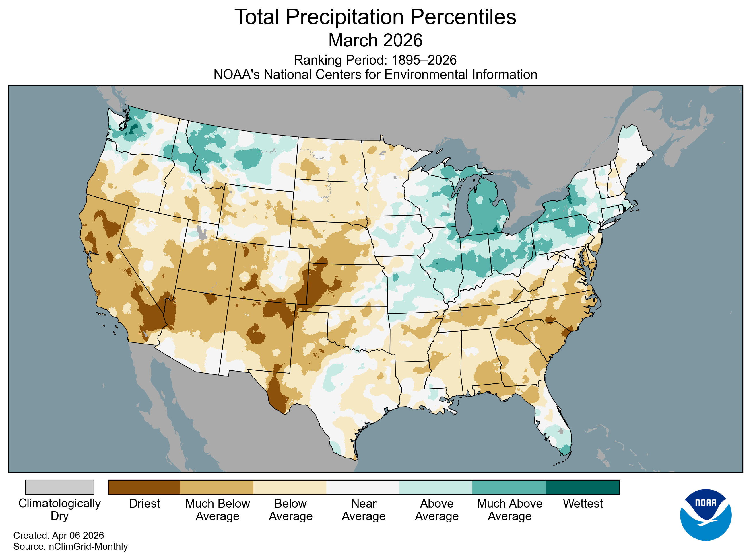 March precipitation was much below average across much of the West, Southwest, portions of the Plains, Deep South and Southeast. In contrast, above-average precipitation totals fell across parts of the Northwest and northern Rockies, as well as across the Upper Midwest and Great Lakes region.
In total, nine states across the Lower-48 ranked among their 10-driest Marches. California received less than a quarter-inch of precipitation statewide—less than 10% of its 20th-century March average and the lowest March total in the 132-year record. Colorado and New Mexico each tied their second-driest March on record, while North and South Carolina each experienced one of their five-driest Marches. In contrast, Michigan received nearly twice its average March precipitation—its third-highest March total on record.
Simultaneously hot and dry conditions affected 12 states, where much-above-average temperatures occurred alongside much-below-average precipitation, with potential impacts on snowpack and water resources in the coming months. California exemplified these extremes, recording both its warmest and driest March on record.
Precipitation across Hawai‘i was much above average for the month, with many areas—including large portions of the Big Island, Maui, Moloka‘i and O‘ahu—experiencing their wettest March on record (since 1991). This exceptional wetness was driven by back-to-back Kona low systems mid-month that triggered widespread major flooding and landslides across the island chain.
Alaska’s statewide precipitation was much lower than average, especially over portions of the Southwest, the Alaska Peninsula and Aleutians. However, the cold air over mainland Alaska brought above-average snowfall to much of Southeast Alaska, with several locations recording their highest March totals in more than a decade.
Drought
According to the March 31 U.S. Drought Monitor report, about 59.9% of the CONUS was in drought, an increase of about 5.0% from the beginning of the month. Drought conditions persisted or intensified across much of the interior West, the Plains, Mississippi Valley, South and Southeast, with notable degradation across the Rockies and central Plains. In contrast, drought contracted or eased across portions of the Midwest, Great Lakes and Northeast.


