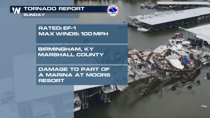
Marshall County, Kentucky Tornado Rated EF-1

Special Stories
24 Jun 2019 4:45 PM
A strong thunderstorm produced a tornado as it moved through Marshall County on Sunday, June 23rd. This is a look at the damage left behind at Moors Resort on Kentucky Lake.
https://gph.is/g/aXpdmlx
The National Weather Service in Paducah, KY rated the tornado an EF-1 with maximum estimated winds around 100 mph. A 50-yard portion of the marina was twisted and overturned. A boat was also overturned and the entire structure was pulled away from shore.
 Strong winds were reported across the rest of Marshall County. Several trees were uprooted and large tree limbs broken.
https://gph.is/g/Z8pmnMd
Severe thunderstorms remain in the forecast for Kentucky and several more states through Monday and into Tuesday. Stick with WeatherNation on-air and online for continued updates.
-Meteorologist Viki Knapp
Strong winds were reported across the rest of Marshall County. Several trees were uprooted and large tree limbs broken.
https://gph.is/g/Z8pmnMd
Severe thunderstorms remain in the forecast for Kentucky and several more states through Monday and into Tuesday. Stick with WeatherNation on-air and online for continued updates.
-Meteorologist Viki KnappAll Weather News
More
More Storms for the East Through Monday
A low-pressure system that moved through the
3 Aug 2026 12:20 PM


After Reaching Category 5, Genevieve Weakens in the Pacific
PacificGenevieve formed last Friday south of
3 Aug 2026 12:30 AM

Flooding, Severe Storms Target the Midwest Again
After an active week of storms across the nor
1 Aug 2026 1:40 AM

Flooding Risk Increases as Heavy Rain Targets the Tri-State Area
Tuesday, heavy rainfall moved across the Nort
30 Jul 2026 12:25 AM

Severe Weather: Energy From the Midwest Now in the Southeast
UPPER MIDWEST - Through Monday, dangerous tor
29 Jul 2026 10:30 PM