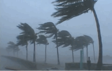
Measuring Winds Using Satellites to Help Predict the Weather
Special Stories
21 Nov 2019 1:40 AM
[NOAA] Wind is a fundamental variable of weather. The heating of Earth’s surface and atmosphere by the sun drives winds that move heat and moisture from one place to another. Variations in large-scale wind circulation patterns are responsible for the daily weather we experience. Indeed, satellite-based wind data are among the most important information contributing to the accuracy of global weather prediction models.
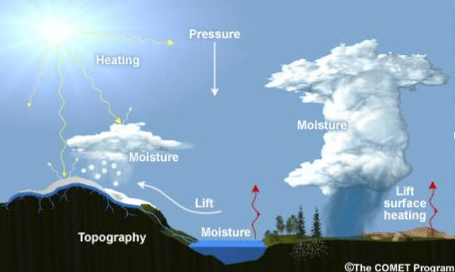 [Parameters affecting weather. Credit: The COMET Program via NOAA]
How do satellites “see” wind?
Satellites estimate winds by tracking the motion of clouds (or water vapor features in the absence of clouds) from a sequence of satellite images. Low Earth-orbiting satellites that circle the Earth from pole to pole around 600 miles up are typically used to understand wind patterns over Earth’s polar regions. Geostationary satellites, like GOES-16 and GOES-17, that stay in place above a set area by orbiting in tandem with the Earth as it turns, provide an almost constant stream of images of a given area, such as the United States. Frequent imaging is especially useful when tracking clouds because they often change shape as they evolve or dissipate. This frequent imaging allows for nearly continuous generation of wind estimates.
What is “wind shear” and how does it lead to thunderstorms?
Vertical wind shear, the change in wind's direction and speed with height, is a critical factor in determining whether severe thunderstorms will develop.
[Parameters affecting weather. Credit: The COMET Program via NOAA]
How do satellites “see” wind?
Satellites estimate winds by tracking the motion of clouds (or water vapor features in the absence of clouds) from a sequence of satellite images. Low Earth-orbiting satellites that circle the Earth from pole to pole around 600 miles up are typically used to understand wind patterns over Earth’s polar regions. Geostationary satellites, like GOES-16 and GOES-17, that stay in place above a set area by orbiting in tandem with the Earth as it turns, provide an almost constant stream of images of a given area, such as the United States. Frequent imaging is especially useful when tracking clouds because they often change shape as they evolve or dissipate. This frequent imaging allows for nearly continuous generation of wind estimates.
What is “wind shear” and how does it lead to thunderstorms?
Vertical wind shear, the change in wind's direction and speed with height, is a critical factor in determining whether severe thunderstorms will develop.
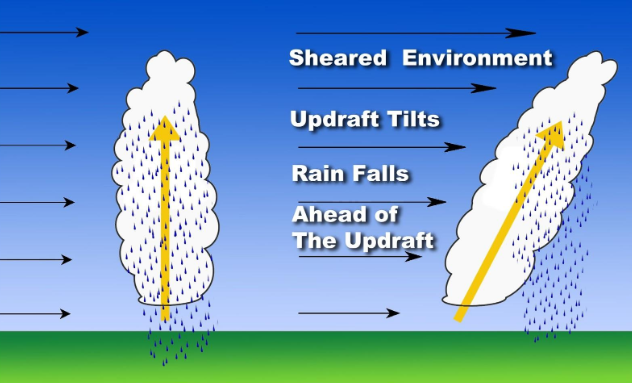 [An example of vertical wind shear. Credit: NOAA/NWS]
In the above image, the thunderstorm on the left has a weakly sheared environment, while the one on the right is in a strongly sheared environment. The storm experiencing little or no wind shear will produce a vertical updraft, and the storm will be short-lived. On the other hand, the storm experiencing strong wind shear will develop a tilted updraft with the rain falling away from the updraft, helping to sustain the storm.
Improved Technology Leads to Better Wind-Monitoring
With advances in satellite technology, forecasters and scientists can utilize near real-time imagery and measurements of wind speeds across multiple levels of the atmosphere like never before.
“Being able to get reliable wind data remotely from satellites helps our meteorologists provide better forecasts and warnings,” explained meteorologist Brian Jackson from the National Weather Service. “Plus, satellite-derived wind data are especially important in areas where direct observations are unavailable, like sparsely populated locations, as well as over the ocean.”
[An example of vertical wind shear. Credit: NOAA/NWS]
In the above image, the thunderstorm on the left has a weakly sheared environment, while the one on the right is in a strongly sheared environment. The storm experiencing little or no wind shear will produce a vertical updraft, and the storm will be short-lived. On the other hand, the storm experiencing strong wind shear will develop a tilted updraft with the rain falling away from the updraft, helping to sustain the storm.
Improved Technology Leads to Better Wind-Monitoring
With advances in satellite technology, forecasters and scientists can utilize near real-time imagery and measurements of wind speeds across multiple levels of the atmosphere like never before.
“Being able to get reliable wind data remotely from satellites helps our meteorologists provide better forecasts and warnings,” explained meteorologist Brian Jackson from the National Weather Service. “Plus, satellite-derived wind data are especially important in areas where direct observations are unavailable, like sparsely populated locations, as well as over the ocean.”
[Parameters affecting weather. Credit: The COMET Program via NOAA]
How do satellites “see” wind?
Satellites estimate winds by tracking the motion of clouds (or water vapor features in the absence of clouds) from a sequence of satellite images. Low Earth-orbiting satellites that circle the Earth from pole to pole around 600 miles up are typically used to understand wind patterns over Earth’s polar regions. Geostationary satellites, like GOES-16 and GOES-17, that stay in place above a set area by orbiting in tandem with the Earth as it turns, provide an almost constant stream of images of a given area, such as the United States. Frequent imaging is especially useful when tracking clouds because they often change shape as they evolve or dissipate. This frequent imaging allows for nearly continuous generation of wind estimates.
What is “wind shear” and how does it lead to thunderstorms?
Vertical wind shear, the change in wind's direction and speed with height, is a critical factor in determining whether severe thunderstorms will develop.
[An example of vertical wind shear. Credit: NOAA/NWS]
In the above image, the thunderstorm on the left has a weakly sheared environment, while the one on the right is in a strongly sheared environment. The storm experiencing little or no wind shear will produce a vertical updraft, and the storm will be short-lived. On the other hand, the storm experiencing strong wind shear will develop a tilted updraft with the rain falling away from the updraft, helping to sustain the storm.
Improved Technology Leads to Better Wind-Monitoring
With advances in satellite technology, forecasters and scientists can utilize near real-time imagery and measurements of wind speeds across multiple levels of the atmosphere like never before.
“Being able to get reliable wind data remotely from satellites helps our meteorologists provide better forecasts and warnings,” explained meteorologist Brian Jackson from the National Weather Service. “Plus, satellite-derived wind data are especially important in areas where direct observations are unavailable, like sparsely populated locations, as well as over the ocean.”
All Weather News
More
More Storms for the East Through Monday
A low-pressure system that moved through the
2 Aug 2026 10:40 PM

Wildfire Outbreak in the Pacific Northwest
SPOKANE, WA - On Saturday, August 1st, the Ol
2 Aug 2026 10:35 PM


After Reaching Category 5, Genevieve Weakens in the Pacific
PacificGenevieve formed on last Friday south
2 Aug 2026 6:25 PM

Flooding, Severe Storms Target the Midwest Again
After an active week of storms across the nor
1 Aug 2026 1:40 AM

Flooding Risk Increases as Heavy Rain Targets the Tri-State Area
Tuesday, heavy rainfall moved across the Nort
30 Jul 2026 12:25 AM

Severe Weather: Energy From the Midwest Now in the Southeast
UPPER MIDWEST - Through Monday, dangerous tor
29 Jul 2026 10:30 PM