Model that Predicts Wildfire Smoke Becomes Operational
Special Stories
12 Jan 2021 2:00 AM
[Written by NOAA] On September 9, San Francisco woke to eerie orange skies. Smoke from the massive August complex wildfire, which ultimately burned more than a million acres in Northern California, was choking the city, blocking out the sun and creating a dystopian gloom.
Bay Area residents anxious to know when the smoke would lift and when it would feel safer to go outside turned to their local forecasters who shared regular updates from a weather forecasting model called the High-Resolution Rapid Refresh Smoke model, or HRRR-Smoke.
During wildfires, first responders and air traffic controllers rely on HRRR-Smoke for visibility. Fire crews consult it when deciding where to pitch base camps or to stage resources. And after a fire passes through, EPA crew workers use it to determine whether the smoke has lifted enough to travel to burned areas to clean up hazardous waste.
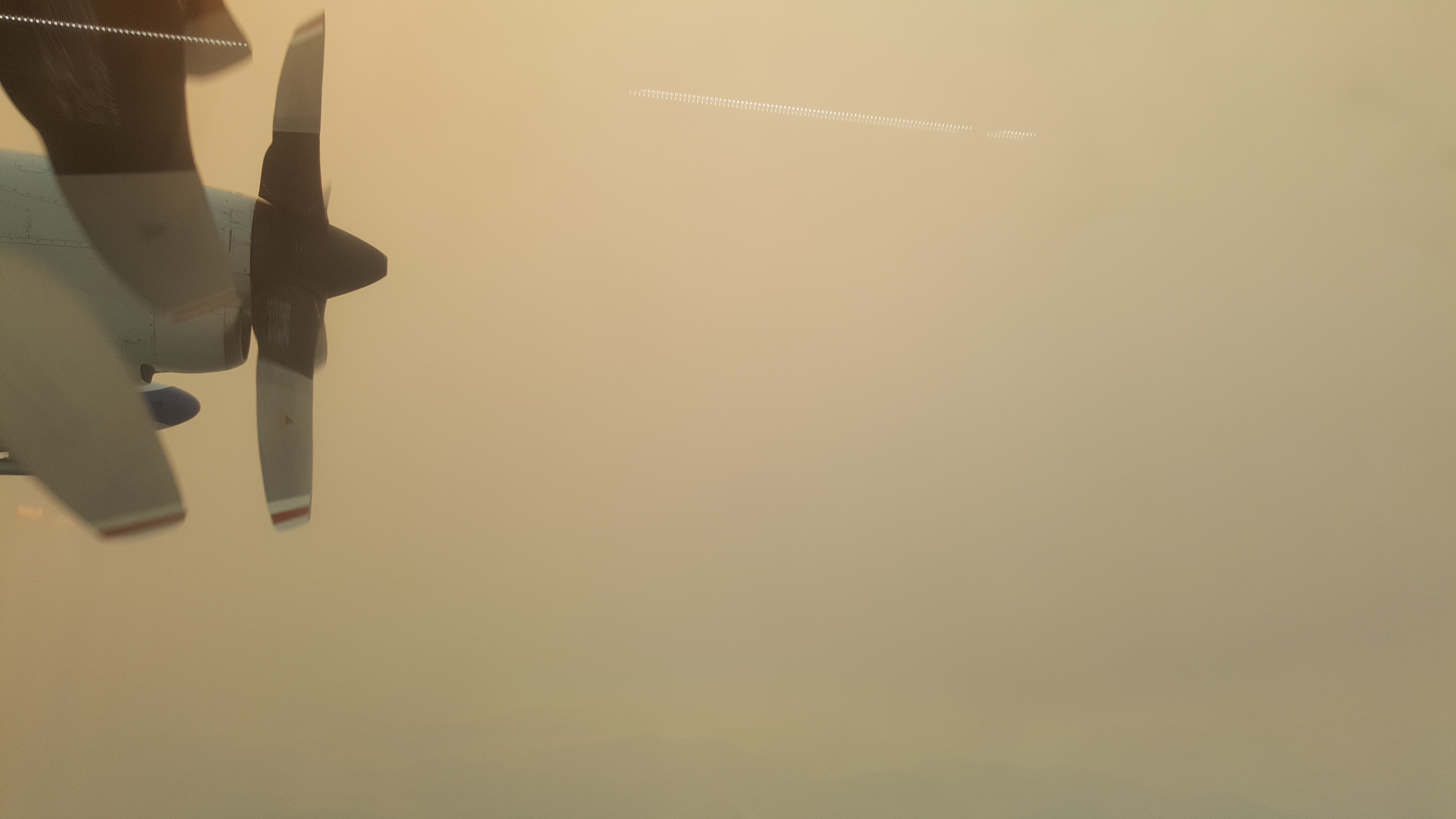 [A view of the smoke from inside the C-130 research aircraft operated by the National Science Foundation and the National Center for Atmospheric Research.Brett Palm/University of Washington]
HRRR-Smoke is the first weather forecast model in the U.S. to include smoke’s impact on weather, and it has been operating experimentally out of NOAA’s Global Systems Laboratory in Colorado since 2016. Earlier this month, after more than a year of rigorous testing, HRRR’s smoke forecasting capabilities were transitioned to NOAA’s National Centers for Environmental Prediction, where thousands of computer processors power a fleet of weather models. There, HRRR-smoke now runs around the clock, producing a new weather and smoke forecast every hour.
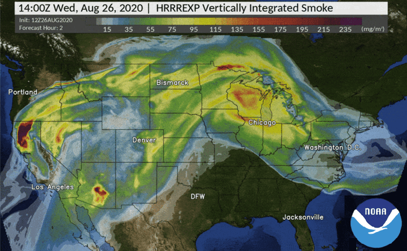
The model ingests real-time data from the NOAA-20 and Suomi-NPP satellites, as well as NASA’s Terra and Aqua satellites. It relies on a metric called fire radiative power, which measures the amount of heat released by a fire in megawatts. The model also uses observations of wind speed, rain and atmospheric temperatures, and combines that with vegetation maps to incorporate what’s burning. All of these measurements are mapped to a three-dimensional grid that extends nearly 12.5 miles into the atmosphere, producing detailed updates of the amount of smoke produced, the plume height and the direction the smoke is expected to move. It also provides forecasts up to 48 hours into the future.
Jeff McQueen, the air quality modeling team leader for the National Weather Service, said that when HRRR-Smoke first emerged, it surprised forecasters with its ability to provide local information on wildfire smoke at a resolution four times greater than what they were accustomed to with other weather models. HRRR-Smoke sees smoke at a spatial resolution of nearly 2 miles by 2 miles per pixel.
https://youtu.be/xQftyQjMeZw
“It was kind of revolutionary the first time we saw smoke forecasts at that resolution,” McQueen said. For the first time, he said, they were seeing how smoke interacted with sea breezes or with air flows east of the Rocky Mountains. “Before this product, smoke would get trapped against the mountains, and we’d miss the true impact of smoke stuck in the valleys,” he said.
As weather drives the behavior of smoke, smoke in turn influences the weather. Smoke that’s blocking incoming radiation can affect both wind speed and temperatures, said Mike Staudenmaier, division chief of the National Weather Service’s Western Region Science and Technology Infusion Division.
“And it can be on the orders of several degrees of temperature differences,” he said. “That’s the exciting thing with this, it’s showing how back and forth engagement between chemistry and atmospheric models can provide a more accurate forecast.”
The recent move to NCEP operations means a more reliable dataset for users, Staudenmaier said.
[A view of the smoke from inside the C-130 research aircraft operated by the National Science Foundation and the National Center for Atmospheric Research.Brett Palm/University of Washington]
HRRR-Smoke is the first weather forecast model in the U.S. to include smoke’s impact on weather, and it has been operating experimentally out of NOAA’s Global Systems Laboratory in Colorado since 2016. Earlier this month, after more than a year of rigorous testing, HRRR’s smoke forecasting capabilities were transitioned to NOAA’s National Centers for Environmental Prediction, where thousands of computer processors power a fleet of weather models. There, HRRR-smoke now runs around the clock, producing a new weather and smoke forecast every hour.
The model ingests real-time data from the NOAA-20 and Suomi-NPP satellites, as well as NASA’s Terra and Aqua satellites. It relies on a metric called fire radiative power, which measures the amount of heat released by a fire in megawatts. The model also uses observations of wind speed, rain and atmospheric temperatures, and combines that with vegetation maps to incorporate what’s burning. All of these measurements are mapped to a three-dimensional grid that extends nearly 12.5 miles into the atmosphere, producing detailed updates of the amount of smoke produced, the plume height and the direction the smoke is expected to move. It also provides forecasts up to 48 hours into the future.
Jeff McQueen, the air quality modeling team leader for the National Weather Service, said that when HRRR-Smoke first emerged, it surprised forecasters with its ability to provide local information on wildfire smoke at a resolution four times greater than what they were accustomed to with other weather models. HRRR-Smoke sees smoke at a spatial resolution of nearly 2 miles by 2 miles per pixel.
https://youtu.be/xQftyQjMeZw
“It was kind of revolutionary the first time we saw smoke forecasts at that resolution,” McQueen said. For the first time, he said, they were seeing how smoke interacted with sea breezes or with air flows east of the Rocky Mountains. “Before this product, smoke would get trapped against the mountains, and we’d miss the true impact of smoke stuck in the valleys,” he said.
As weather drives the behavior of smoke, smoke in turn influences the weather. Smoke that’s blocking incoming radiation can affect both wind speed and temperatures, said Mike Staudenmaier, division chief of the National Weather Service’s Western Region Science and Technology Infusion Division.
“And it can be on the orders of several degrees of temperature differences,” he said. “That’s the exciting thing with this, it’s showing how back and forth engagement between chemistry and atmospheric models can provide a more accurate forecast.”
The recent move to NCEP operations means a more reliable dataset for users, Staudenmaier said.
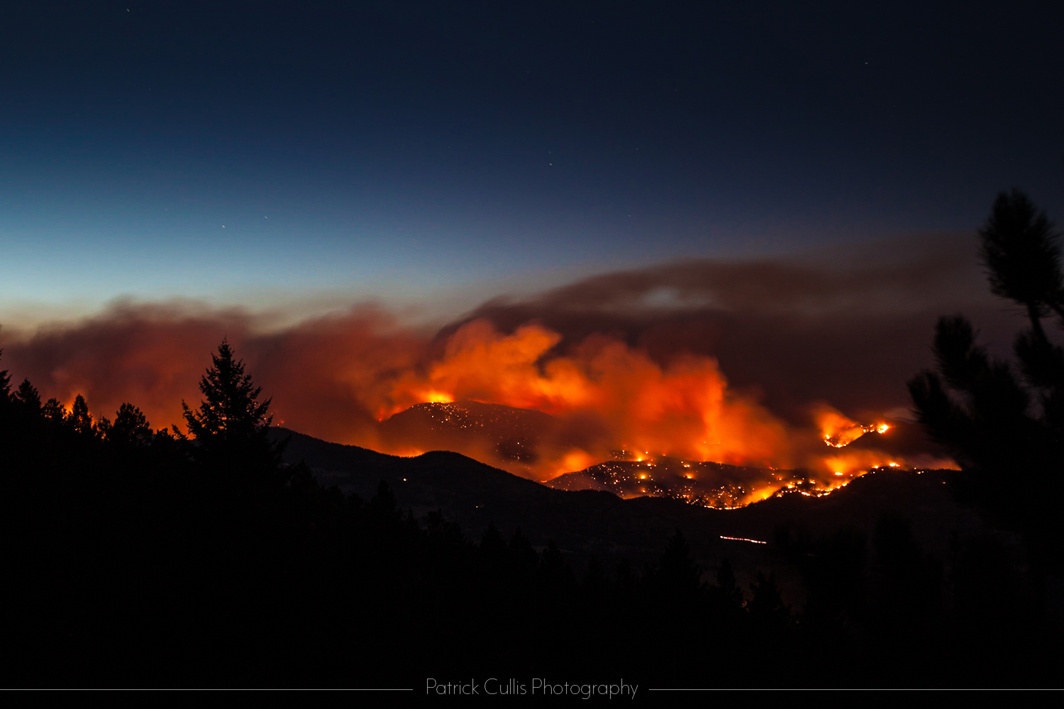 [NOAA's HRRR-Smoke model can help warn fire managers and local communities where heavy smoke will collect when a fire "lays down" overnight, as the Four Mile Fire did in Boulder Colorado in 2010. Credit: Patrick Cullis/CIRES]
“When something is experimental, we’re at the whims of bandwidth, availability, that kind of thing,” he said. “If a server or computer system goes belly up, that data is not available. Now that it’s operational, it has a requirement to be available at least 99 percent of the time.”
It will also free up Ravan Ahmadov and his coworkers to separately focus on research and future updates. Ahmadov, a CIRES scientist working in the Global Systems Laboratory, is the main developer of HRRR-Smoke.
Ahmadov said his hope in future models is to better characterize and forecast the rapid changes in fire intensity, in part by bringing in new satellite data from the GOES-16 satellite and the future JPSS-2 satellite, which is slated to launch in 2022.
“Over the next several years, there will be two systems,” Ahmadov said. “One is fully operational and won’t change much. Another experimental system will be changing and improving.”
To see the latest HRRR-Smoke model visualization, go to: https://hwp-viz.gsd.esrl.noaa.gov/smoke/index.html
[NOAA's HRRR-Smoke model can help warn fire managers and local communities where heavy smoke will collect when a fire "lays down" overnight, as the Four Mile Fire did in Boulder Colorado in 2010. Credit: Patrick Cullis/CIRES]
“When something is experimental, we’re at the whims of bandwidth, availability, that kind of thing,” he said. “If a server or computer system goes belly up, that data is not available. Now that it’s operational, it has a requirement to be available at least 99 percent of the time.”
It will also free up Ravan Ahmadov and his coworkers to separately focus on research and future updates. Ahmadov, a CIRES scientist working in the Global Systems Laboratory, is the main developer of HRRR-Smoke.
Ahmadov said his hope in future models is to better characterize and forecast the rapid changes in fire intensity, in part by bringing in new satellite data from the GOES-16 satellite and the future JPSS-2 satellite, which is slated to launch in 2022.
“Over the next several years, there will be two systems,” Ahmadov said. “One is fully operational and won’t change much. Another experimental system will be changing and improving.”
To see the latest HRRR-Smoke model visualization, go to: https://hwp-viz.gsd.esrl.noaa.gov/smoke/index.html
[A view of the smoke from inside the C-130 research aircraft operated by the National Science Foundation and the National Center for Atmospheric Research.Brett Palm/University of Washington]
HRRR-Smoke is the first weather forecast model in the U.S. to include smoke’s impact on weather, and it has been operating experimentally out of NOAA’s Global Systems Laboratory in Colorado since 2016. Earlier this month, after more than a year of rigorous testing, HRRR’s smoke forecasting capabilities were transitioned to NOAA’s National Centers for Environmental Prediction, where thousands of computer processors power a fleet of weather models. There, HRRR-smoke now runs around the clock, producing a new weather and smoke forecast every hour.
The model ingests real-time data from the NOAA-20 and Suomi-NPP satellites, as well as NASA’s Terra and Aqua satellites. It relies on a metric called fire radiative power, which measures the amount of heat released by a fire in megawatts. The model also uses observations of wind speed, rain and atmospheric temperatures, and combines that with vegetation maps to incorporate what’s burning. All of these measurements are mapped to a three-dimensional grid that extends nearly 12.5 miles into the atmosphere, producing detailed updates of the amount of smoke produced, the plume height and the direction the smoke is expected to move. It also provides forecasts up to 48 hours into the future.
Jeff McQueen, the air quality modeling team leader for the National Weather Service, said that when HRRR-Smoke first emerged, it surprised forecasters with its ability to provide local information on wildfire smoke at a resolution four times greater than what they were accustomed to with other weather models. HRRR-Smoke sees smoke at a spatial resolution of nearly 2 miles by 2 miles per pixel.
https://youtu.be/xQftyQjMeZw
“It was kind of revolutionary the first time we saw smoke forecasts at that resolution,” McQueen said. For the first time, he said, they were seeing how smoke interacted with sea breezes or with air flows east of the Rocky Mountains. “Before this product, smoke would get trapped against the mountains, and we’d miss the true impact of smoke stuck in the valleys,” he said.
As weather drives the behavior of smoke, smoke in turn influences the weather. Smoke that’s blocking incoming radiation can affect both wind speed and temperatures, said Mike Staudenmaier, division chief of the National Weather Service’s Western Region Science and Technology Infusion Division.
“And it can be on the orders of several degrees of temperature differences,” he said. “That’s the exciting thing with this, it’s showing how back and forth engagement between chemistry and atmospheric models can provide a more accurate forecast.”
The recent move to NCEP operations means a more reliable dataset for users, Staudenmaier said.
[NOAA's HRRR-Smoke model can help warn fire managers and local communities where heavy smoke will collect when a fire "lays down" overnight, as the Four Mile Fire did in Boulder Colorado in 2010. Credit: Patrick Cullis/CIRES]
“When something is experimental, we’re at the whims of bandwidth, availability, that kind of thing,” he said. “If a server or computer system goes belly up, that data is not available. Now that it’s operational, it has a requirement to be available at least 99 percent of the time.”
It will also free up Ravan Ahmadov and his coworkers to separately focus on research and future updates. Ahmadov, a CIRES scientist working in the Global Systems Laboratory, is the main developer of HRRR-Smoke.
Ahmadov said his hope in future models is to better characterize and forecast the rapid changes in fire intensity, in part by bringing in new satellite data from the GOES-16 satellite and the future JPSS-2 satellite, which is slated to launch in 2022.
“Over the next several years, there will be two systems,” Ahmadov said. “One is fully operational and won’t change much. Another experimental system will be changing and improving.”
To see the latest HRRR-Smoke model visualization, go to: https://hwp-viz.gsd.esrl.noaa.gov/smoke/index.htmlAll Weather News
More
Tropics: Fausto Heads towards Hawaii; Genevieve Cat 4 Hurricane
PacificTropical Storm Fausto continues to tra
28 Jul 2026 2:30 PM

Severe Storms Move From Midwest to Northeast
UPPER MIDWEST - Through Monday, dangerous tor
28 Jul 2026 2:25 PM


Southeast Flood Risk Lingers Near Stalled Front
A stalled boundary over the Southeast will ke
25 Jul 2026 10:55 AM

Another Round of Storms Targets the Northeast
Tuesday brought severe weather again across p
23 Jul 2026 1:15 AM

Another Round of Severe Weather for the Upper Midwest and Great Lakes
The upper-level low train continues to keep t
21 Jul 2026 1:45 AM