NASA's ARIA Team Maps California Quake Damage
Special Stories
18 Jul 2019 1:28 AM
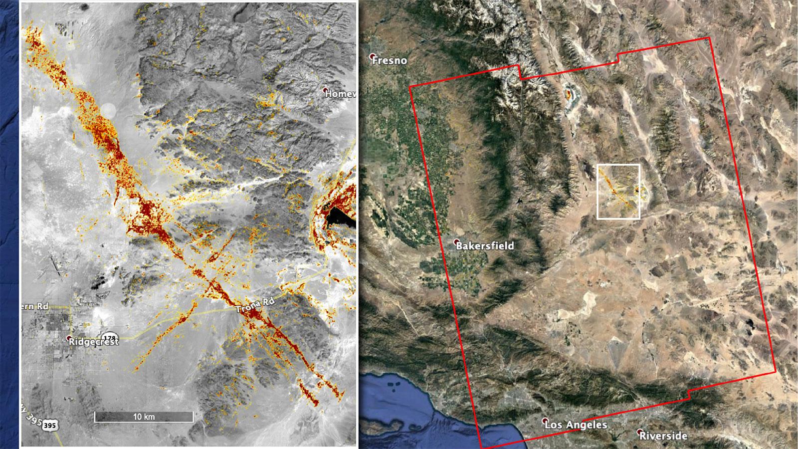
[NASA's ARIA team produced this map of earthquake damage in Southern California from the recent temblors. The color variation from yellow to red indicates increasingly more significant surface change, or damage. Credits: NASA/JPL-Caltech, ESA]
[NASA] After the recent strong earthquakes that struck near the city of Ridgecrest in Southern California, NASA scientists and engineers continue to analyze satellite data for information on fault slips and ruptures. Their observations are helping local authorities assess damage and will also provide useful information to engineers for designing resilient structures that can withstand ruptures like the ones created by the latest quakes.
https://www.facebook.com/WeatherNation/videos/790970887966847/
The Advanced Rapid Imaging and Analysis (ARIA) team at NASA's Jet Propulsion Laboratory in Pasadena, California, created this map depicting areas that are likely damaged as a result of the recent major earthquakes. The color variation from yellow to red indicates increasingly more significant surface change, or damage. The map covers an area of 155 by 186 miles (250 by 300 kilometers), shown by the large red polygon. Each pixel measures about 33 yards (30 meters) across.
https://www.facebook.com/WeatherNation/videos/2095341780575577/
To make the map, the team used synthetic aperture radar (SAR) images from the European Space Agency's Copernicus Sentinel-1 satellites from before and after the sequence of quakes — July 4 and July 10, 2019, respectively. The map may be less reliable over vegetated areas but can provide useful guidance in identifying damaged areas.
https://twitter.com/gretchengillis/status/1146852519659761664
NASA's Disasters Program is in communication with the California Earthquake Clearinghouse, which is coordinating response efforts with the California Air National Guard, the U.S. Geological Service and the Federal Emergency Management Agency. NASA analysts are using data from satellites to produce visualizations of land deformation and potential landslides, among other earthquake impacts, and are making them available to response agencies. NASA's Disasters Program promotes the use of satellite observations in predicting, preparing for, responding to and recovering from disasters around the world.
Edited for WeatherNation by Meteorologist Mace Michaels
All Weather News
More
Tropical Storm Chantal Forms This Morning
Tropical Storm Chantal has formed, with winds
5 Jul 2025 4:35 PM

Catastrophic Flooding in the Texas Hill Country
Multiple Flash Flood Emergencies were issued
5 Jul 2025 4:35 PM


Severe Storms in the Midwest Continue To Spoil the Holiday Weekend
NORTHERN PLAINS - A frontal system continues
5 Jul 2025 8:30 AM

Near Seasonal Temperatures for Many Come July 4th!
AAA is expecting over 70 million travelers to
4 Jul 2025 10:15 AM


Northwest Heat Met With Thunderstorm Risk
NORTHWEST - Today, portions of Montana are un
3 Jul 2025 12:00 AM