National Weather Service Implementing Improved Warning Software
Special Stories
28 Feb 2020 3:00 AM
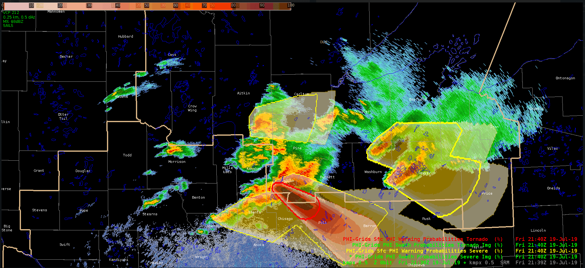
[Yellow shading is a Probabilistic Hazard Information (PHI) object and red shading is the “Threats in Motion” object workflow being evaluated in the NOAA Hazardous Weather Testbed.]
[From OU written by Emily Summars] NOAA National Weather Service forecasters from across the United States visit Norman each year to train on the tools they use every day to save lives and property. But this year the NOAA NWS Warning Decision Training Division Office of Chief Learning Officer implemented new training.
Researchers at the University of Oklahoma Cooperative Institute for Mesoscale Meteorological Studies trained forecasters and NWS staff in the NWS WDTD Hazard Services Focal Point Workshop. This in-residence workshop provided by OU CIMMS and NWS WDTD is the only one, and the first, of its kind. The workshop focused on training 122 forecasters, one from each NWS forecasting office, on a new warning software.
NWS forecasters use WarnGen and a suite of specialized products to currently issue warnings. Having several products in different areas can be laborious. Hazard Services maximizes efficiency and places all of these products in one area, allowing more flexibility.
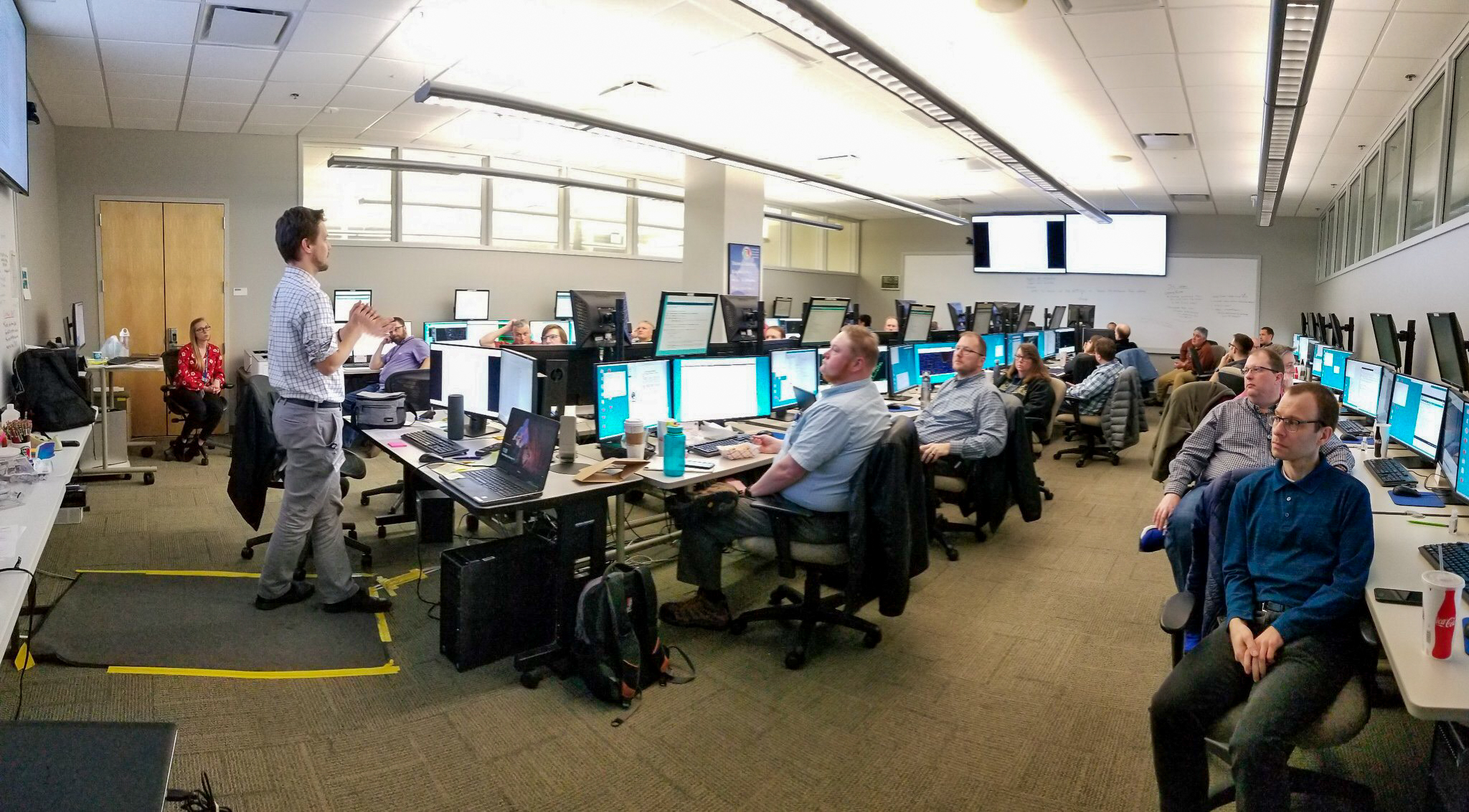 [Eric Jacobsen teaching an aspect of the NWS WDTD Hazard Services Focal Point Workshop to NWS forecasters. (Photo by Mike Magsig/NWS WDTD Workshop Lead)]
“Hazard Services faithfully replicates preexisting products. Forecasters have more customization options, flexibility and it provides a more efficient, consolidated workflow,” said Eric Jacobsen, OU CIMMS research associate supporting NWS WDTD.
The training workshop allowed forecasters the time and opportunity to set up and customize their Hazard Services look and feel. Forecasters arrive in Norman with five hours of training before they begin with short sessions, a list of tasks, and free time to ask questions or problem solve.
“Some of the participants have never seen hazard services before,” said Sarah Borg, OU CIMMS research associate supporting NWS WDTD. “NWS is implementing hazard services into operations in a multi-step approach. We do a quick run-through of what Hazard Services looks like because it can be difficult to orient yourself with the product. This isn’t like other WDTD workshops.”
[Eric Jacobsen teaching an aspect of the NWS WDTD Hazard Services Focal Point Workshop to NWS forecasters. (Photo by Mike Magsig/NWS WDTD Workshop Lead)]
“Hazard Services faithfully replicates preexisting products. Forecasters have more customization options, flexibility and it provides a more efficient, consolidated workflow,” said Eric Jacobsen, OU CIMMS research associate supporting NWS WDTD.
The training workshop allowed forecasters the time and opportunity to set up and customize their Hazard Services look and feel. Forecasters arrive in Norman with five hours of training before they begin with short sessions, a list of tasks, and free time to ask questions or problem solve.
“Some of the participants have never seen hazard services before,” said Sarah Borg, OU CIMMS research associate supporting NWS WDTD. “NWS is implementing hazard services into operations in a multi-step approach. We do a quick run-through of what Hazard Services looks like because it can be difficult to orient yourself with the product. This isn’t like other WDTD workshops.”
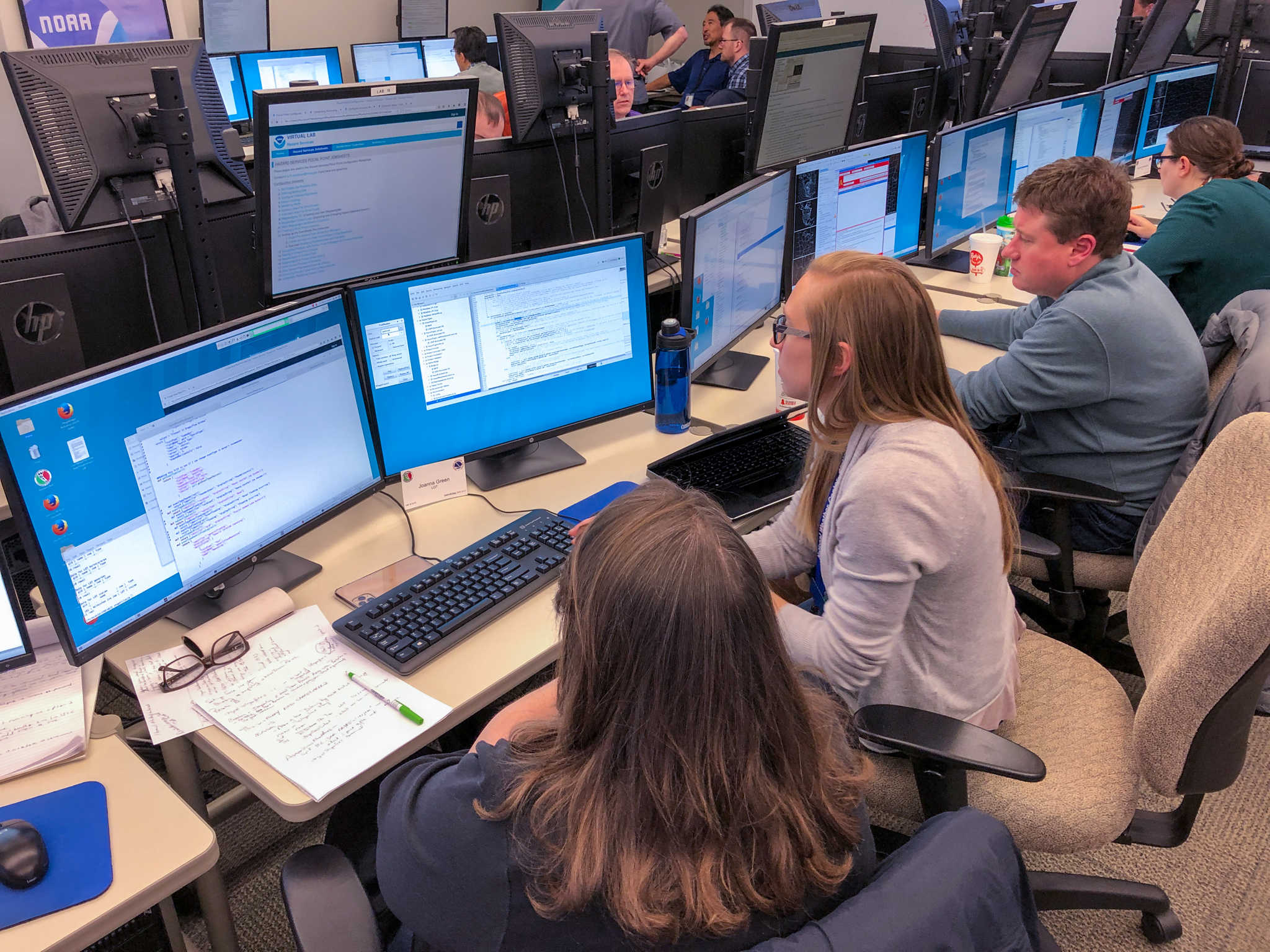 [Sarah Borg working with a NWS forecaster on some coding issues. (Photo by Emily Summars-Jeffries/OU CIMMS)]
The first set of products implemented in Hazard Services are related to flood watches and warnings. Some participants are hydrologists and specialize in flood warnings, while others are experts at the computer code used to build the Hazard Services configuration.
At the end of the three-day training, forecasters took their customized Hazard Services configurations back to their home office.
“They can set it up in their home office and can use it as soon as the software is installed,” Jacobsen said. “There’s such a diverse skill set. In these workshops. People come here and not only learn from us but end up helping each other out.”
[Sarah Borg working with a NWS forecaster on some coding issues. (Photo by Emily Summars-Jeffries/OU CIMMS)]
The first set of products implemented in Hazard Services are related to flood watches and warnings. Some participants are hydrologists and specialize in flood warnings, while others are experts at the computer code used to build the Hazard Services configuration.
At the end of the three-day training, forecasters took their customized Hazard Services configurations back to their home office.
“They can set it up in their home office and can use it as soon as the software is installed,” Jacobsen said. “There’s such a diverse skill set. In these workshops. People come here and not only learn from us but end up helping each other out.”
 “We encourage people who are neighbors in the NWS, or who back each other up, to sit next to each other in the workshop. They may face the same problems, so in some of the flexible time we give them during the workshop, we see a lot of them working together to solve the issue they both have because they both have the same policy in those areas of the U.S. That goes a long way in strengthening their relationship and avoids reinventing the wheel,” he said.
At the end of the multiple session training, Borg and Jacobsen helped set up and test 122 customized Hazard Services setups with the help of NOAA’s Earth System Research Laboratory Global System Division.
“This is the only time the workshop is offered to jumpstart the implementation of hazard services,” Borg said. “Forecasters will train others in their office and share the knowledge they learned in Norman.”
“We encourage people who are neighbors in the NWS, or who back each other up, to sit next to each other in the workshop. They may face the same problems, so in some of the flexible time we give them during the workshop, we see a lot of them working together to solve the issue they both have because they both have the same policy in those areas of the U.S. That goes a long way in strengthening their relationship and avoids reinventing the wheel,” he said.
At the end of the multiple session training, Borg and Jacobsen helped set up and test 122 customized Hazard Services setups with the help of NOAA’s Earth System Research Laboratory Global System Division.
“This is the only time the workshop is offered to jumpstart the implementation of hazard services,” Borg said. “Forecasters will train others in their office and share the knowledge they learned in Norman.”
[Eric Jacobsen teaching an aspect of the NWS WDTD Hazard Services Focal Point Workshop to NWS forecasters. (Photo by Mike Magsig/NWS WDTD Workshop Lead)]
“Hazard Services faithfully replicates preexisting products. Forecasters have more customization options, flexibility and it provides a more efficient, consolidated workflow,” said Eric Jacobsen, OU CIMMS research associate supporting NWS WDTD.
The training workshop allowed forecasters the time and opportunity to set up and customize their Hazard Services look and feel. Forecasters arrive in Norman with five hours of training before they begin with short sessions, a list of tasks, and free time to ask questions or problem solve.
“Some of the participants have never seen hazard services before,” said Sarah Borg, OU CIMMS research associate supporting NWS WDTD. “NWS is implementing hazard services into operations in a multi-step approach. We do a quick run-through of what Hazard Services looks like because it can be difficult to orient yourself with the product. This isn’t like other WDTD workshops.”
[Sarah Borg working with a NWS forecaster on some coding issues. (Photo by Emily Summars-Jeffries/OU CIMMS)]
The first set of products implemented in Hazard Services are related to flood watches and warnings. Some participants are hydrologists and specialize in flood warnings, while others are experts at the computer code used to build the Hazard Services configuration.
At the end of the three-day training, forecasters took their customized Hazard Services configurations back to their home office.
“They can set it up in their home office and can use it as soon as the software is installed,” Jacobsen said. “There’s such a diverse skill set. In these workshops. People come here and not only learn from us but end up helping each other out.”
“We encourage people who are neighbors in the NWS, or who back each other up, to sit next to each other in the workshop. They may face the same problems, so in some of the flexible time we give them during the workshop, we see a lot of them working together to solve the issue they both have because they both have the same policy in those areas of the U.S. That goes a long way in strengthening their relationship and avoids reinventing the wheel,” he said.
At the end of the multiple session training, Borg and Jacobsen helped set up and test 122 customized Hazard Services setups with the help of NOAA’s Earth System Research Laboratory Global System Division.
“This is the only time the workshop is offered to jumpstart the implementation of hazard services,” Borg said. “Forecasters will train others in their office and share the knowledge they learned in Norman.”All Weather News
More
More Storms for the East Through Monday
A low-pressure system that moved through the
2 Aug 2026 10:40 PM

Wildfire Outbreak in the Pacific Northwest
SPOKANE, WA - On Saturday, August 1st, the Ol
2 Aug 2026 10:35 PM


After Reaching Category 5, Genevieve Weakens in the Pacific
PacificGenevieve formed on last Friday south
2 Aug 2026 6:25 PM

Flooding, Severe Storms Target the Midwest Again
After an active week of storms across the nor
1 Aug 2026 1:40 AM

Flooding Risk Increases as Heavy Rain Targets the Tri-State Area
Tuesday, heavy rainfall moved across the Nort
30 Jul 2026 12:25 AM

Severe Weather: Energy From the Midwest Now in the Southeast
UPPER MIDWEST - Through Monday, dangerous tor
29 Jul 2026 10:30 PM