New Maps Show Extent Of February Snow
Special Stories
3 Mar 2021 9:30 PM
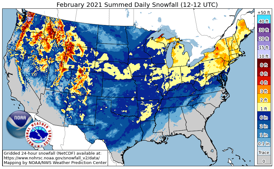
The Weather Prediction Center released a couple of graphics Wednesday showing just how widespread snowfall was for the month of February 2021. In the first image, below, the snowfall analysis for the month of February was truly impressive. Nearly every state was touched by at least some new snowfall accumulation. Of course, note how far south the snow accumulations were, plus how many inches fell!
 Next, the image below shows the departure from average for snowfall during February 2021. Areas of blue and green represent an above-average snowfall. Areas of interest, of course, were the Deep South snowy locations and also the Interstate 95 corridor near the New York City and Philadelphia area. Brown-shaded areas were below average.
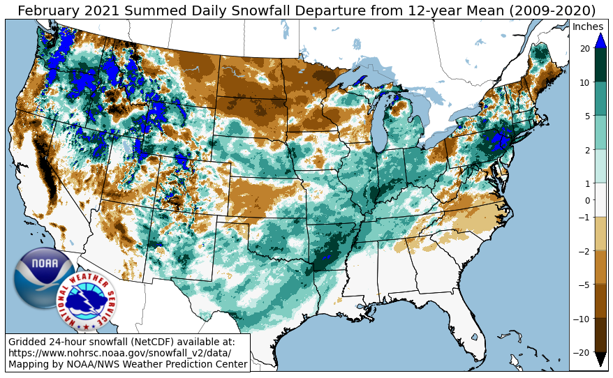 Much of the February snowfall has melted away as the temperature pattern has warmed considerably for the start of March. These new images remind us how unprecedented the snow was in an historic February for winter weather here in the United States.
All images courtesy NOAA's Weather Prediction Center
Much of the February snowfall has melted away as the temperature pattern has warmed considerably for the start of March. These new images remind us how unprecedented the snow was in an historic February for winter weather here in the United States.
All images courtesy NOAA's Weather Prediction Center
Next, the image below shows the departure from average for snowfall during February 2021. Areas of blue and green represent an above-average snowfall. Areas of interest, of course, were the Deep South snowy locations and also the Interstate 95 corridor near the New York City and Philadelphia area. Brown-shaded areas were below average.
Much of the February snowfall has melted away as the temperature pattern has warmed considerably for the start of March. These new images remind us how unprecedented the snow was in an historic February for winter weather here in the United States.
All images courtesy NOAA's Weather Prediction CenterAll Weather News
More
More Storms for the East Through Monday
A low-pressure system that moved through the
2 Aug 2026 10:40 PM

Wildfire Outbreak in the Pacific Northwest
SPOKANE, WA - On Saturday, August 1st, the Ol
2 Aug 2026 10:35 PM


After Reaching Category 5, Genevieve Weakens in the Pacific
PacificGenevieve formed on last Friday south
2 Aug 2026 6:25 PM

Flooding, Severe Storms Target the Midwest Again
After an active week of storms across the nor
1 Aug 2026 1:40 AM

Flooding Risk Increases as Heavy Rain Targets the Tri-State Area
Tuesday, heavy rainfall moved across the Nort
30 Jul 2026 12:25 AM

Severe Weather: Energy From the Midwest Now in the Southeast
UPPER MIDWEST - Through Monday, dangerous tor
29 Jul 2026 10:30 PM