Powerful Storm To Impact Southern California
Top Stories
6 Jan 2018 6:43 PM
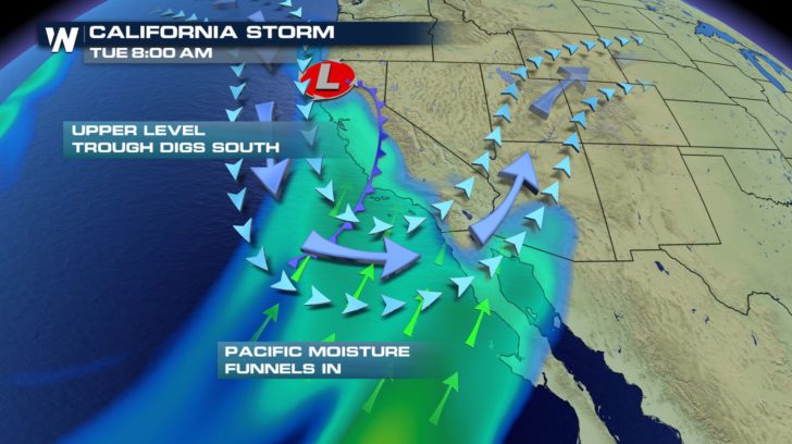
It's been almost a year since Southern California has seen a significant winter storm like the one in the forecast Monday night into Tuesday.
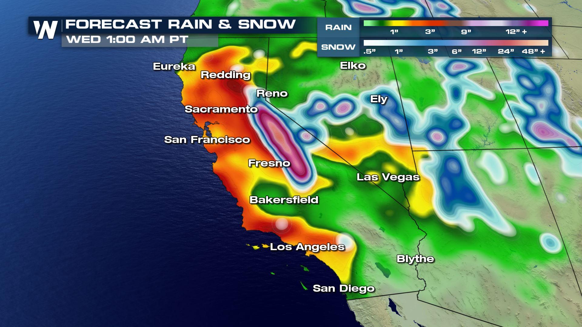
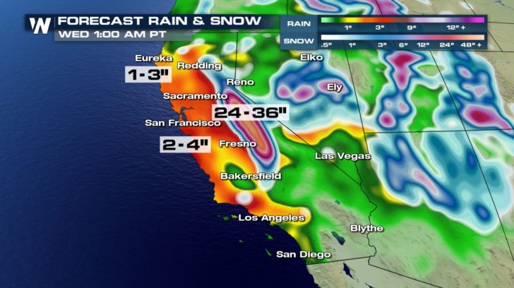
 According to the National Weather Service in Los Angeles, rainfall rates could reach 0.50"-1.0" an hour during the peak of the storm.
The heaviest of the rain is expected to fall overnight, and final storm totals could get up to 4-5" in some spots.
According to the National Weather Service in Los Angeles, rainfall rates could reach 0.50"-1.0" an hour during the peak of the storm.
The heaviest of the rain is expected to fall overnight, and final storm totals could get up to 4-5" in some spots.
 https://twitter.com/twitter/statuses/949861284626878464
It is likely we will see mud and debris flows in the recent burn areas, especially in and near the Thomas, Creek, and La Tuna burn areas with the current rainfall rates in the forecast.
https://twitter.com/twitter/statuses/949809220722937856
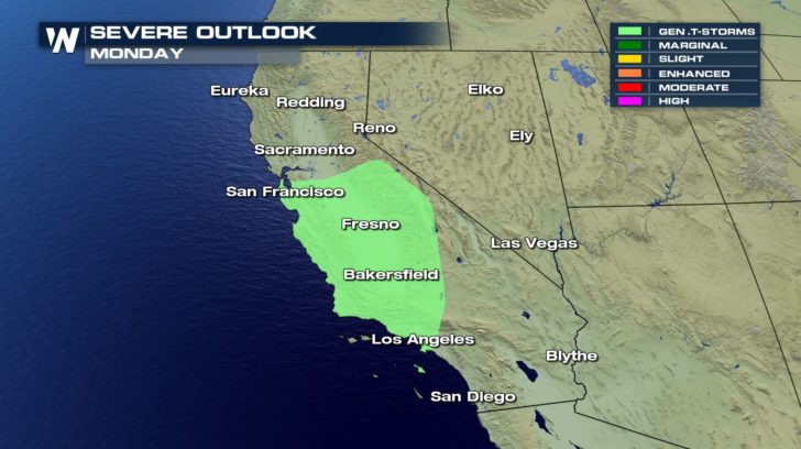
Thunderstorms are also possible which could lead to higher rain rates and an increased threat of flooding and flash flooding.
https://twitter.com/twitter/statuses/949861284626878464
It is likely we will see mud and debris flows in the recent burn areas, especially in and near the Thomas, Creek, and La Tuna burn areas with the current rainfall rates in the forecast.
https://twitter.com/twitter/statuses/949809220722937856
Thunderstorms are also possible which could lead to higher rain rates and an increased threat of flooding and flash flooding.
 Residents in Southern California should also be prepared for urban/street flooding and rockslides as well as ponding of water on roads and in intersections.
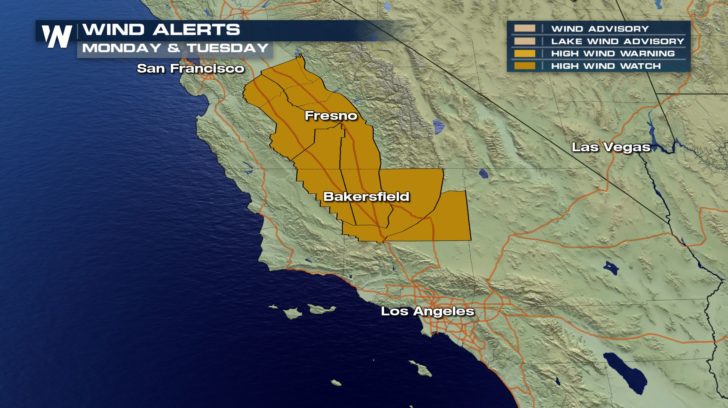
Potentially damaging winds are also possible in the mountains and desert with this storm, and High Wind Watches have already been issued from Fresno to Bakersfield.
Residents in Southern California should also be prepared for urban/street flooding and rockslides as well as ponding of water on roads and in intersections.
Potentially damaging winds are also possible in the mountains and desert with this storm, and High Wind Watches have already been issued from Fresno to Bakersfield.
 For WeatherNation, I'm Meteorologist Meredith Garofalo
According to the National Weather Service in Los Angeles, rainfall rates could reach 0.50"-1.0" an hour during the peak of the storm.
The heaviest of the rain is expected to fall overnight, and final storm totals could get up to 4-5" in some spots.
https://twitter.com/twitter/statuses/949861284626878464
It is likely we will see mud and debris flows in the recent burn areas, especially in and near the Thomas, Creek, and La Tuna burn areas with the current rainfall rates in the forecast.
https://twitter.com/twitter/statuses/949809220722937856
Thunderstorms are also possible which could lead to higher rain rates and an increased threat of flooding and flash flooding.
Residents in Southern California should also be prepared for urban/street flooding and rockslides as well as ponding of water on roads and in intersections.
Potentially damaging winds are also possible in the mountains and desert with this storm, and High Wind Watches have already been issued from Fresno to Bakersfield.
For WeatherNation, I'm Meteorologist Meredith GarofaloAll Weather News
More
Catastrophic Flooding in the Texas Hill Country
Multiple Flash Flood Emergencies were issued
5 Jul 2025 10:20 PM

Severe Storms in the Midwest Continue To Spoil the Holiday Weekend
NORTHERN PLAINS - A frontal system continues
5 Jul 2025 10:15 PM

Tropical Storm Chantal Forms This Morning
Tropical Storm Chantal has formed, with winds
5 Jul 2025 4:35 PM


Near Seasonal Temperatures for Many Come July 4th!
AAA is expecting over 70 million travelers to
4 Jul 2025 10:15 AM


Northwest Heat Met With Thunderstorm Risk
NORTHWEST - Today, portions of Montana are un
3 Jul 2025 12:00 AM