Researchers Find Pathway to Give Advanced Notice for Hailstorms
Special Stories
9 Mar 2018 8:51 AM
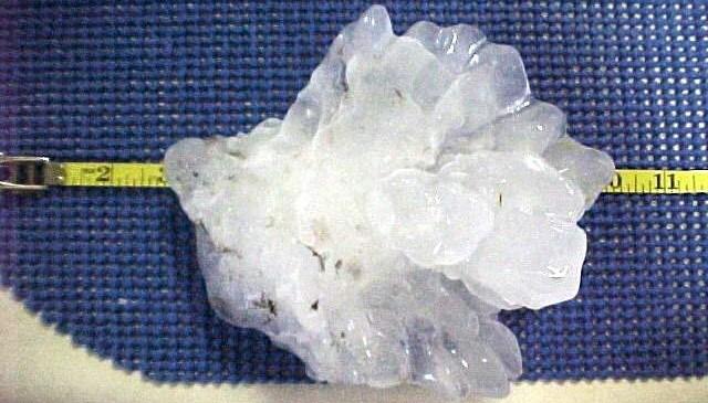
[Largest hailstone ever recovered in the United States fell in Aurora on June 22, 2003 with a record 7-inch diameter and a circumference of 18.75 inches. From NOAA]
From Northern Illinois University
A study led by Northern Illinois University meteorologist Victor Gensini identifies a method for predicting the likelihood of damaging hailstorms in the United States—up to three weeks in advance.
Hail is easily the most economically destructive hazard posed by severe thunderstorms, producing on average billions of dollars in U.S. losses each year, including damage to roofs, homes and especially crops.
“We found a really strong relationship between jet stream patterns over the Pacific Ocean and U.S. hail frequency,” Gensini said. “In simple terms, when the jet stream is really wavy, the likelihood of experiencing hail greatly increases.”
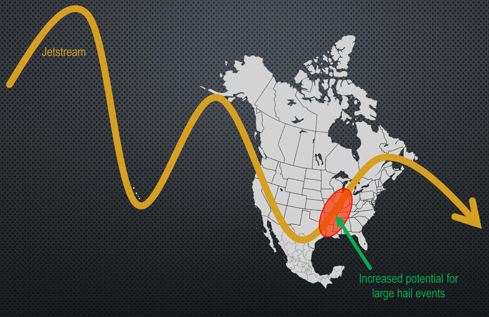 [New research finds a strong relationship between a wavy jet-stream pattern over the Pacific Ocean and severe U.S. hailstorms. Credit: Victor Gensini, NIU]
The study by Gensini and co-author John Allen of Central Michigan University was accepted for publication in the journal, Geophysical Research Letters.
Two years ago, Gensini led research on a method to predict the likelihood of U.S. tornado activity weeks in advance. Last year, of 26 long-range (two to three weeks) forecasts for increased, average or below average U.S. tornado activity, more than half were “spot on,” Gensini said. Most of the other predictions were only slightly off.
The new study is an extension of the tornado research, suggesting a similar method can be used in sub-seasonal forecasts of hailstorms. “There’s a high degree of correlation between environments that produce hail and tornadoes, but not all storms produce both hazards,” said Gensini, a professor in the NIU Department of Geographic and Atmospheric Sciences.
While the method would be used to forecast hail activity for the country in general, portions of Texas, Oklahoma, Arkansas, Kentucky, Missouri, Mississippi, Tennessee, Illinois and Indiana are most vulnerable to the phenomenon.
[New research finds a strong relationship between a wavy jet-stream pattern over the Pacific Ocean and severe U.S. hailstorms. Credit: Victor Gensini, NIU]
The study by Gensini and co-author John Allen of Central Michigan University was accepted for publication in the journal, Geophysical Research Letters.
Two years ago, Gensini led research on a method to predict the likelihood of U.S. tornado activity weeks in advance. Last year, of 26 long-range (two to three weeks) forecasts for increased, average or below average U.S. tornado activity, more than half were “spot on,” Gensini said. Most of the other predictions were only slightly off.
The new study is an extension of the tornado research, suggesting a similar method can be used in sub-seasonal forecasts of hailstorms. “There’s a high degree of correlation between environments that produce hail and tornadoes, but not all storms produce both hazards,” said Gensini, a professor in the NIU Department of Geographic and Atmospheric Sciences.
While the method would be used to forecast hail activity for the country in general, portions of Texas, Oklahoma, Arkansas, Kentucky, Missouri, Mississippi, Tennessee, Illinois and Indiana are most vulnerable to the phenomenon.
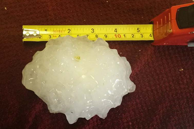 [This hailstone retrieved in June 2015, with a diameter of 4.75 inches, is the state record for Illinois. Photo from the State Climate Extremes Committee report that documented its occurrence and retrieval.]
Gensini and Allen examined hail observations from national storm data for the period of 1979 to 2016. They compared those events with changes in the Global Wind Oscillation (GWO) index, a collection of climate and weather information that measures atmospheric angular momentum, or the degree of waviness in the jet stream.
The GWO index has eight distinct phases. Four of those phases were reliable predictors of increased inland hail activity during peak storm seasons, according to the study.
“There is a strong connection between the GWO and U.S. hail frequency,” Allen said. “This relationship helps to understand what is driving hail variability, and explains to a large degree when we are likely to experience active and inactive periods during the spring and fall.”
[This hailstone retrieved in June 2015, with a diameter of 4.75 inches, is the state record for Illinois. Photo from the State Climate Extremes Committee report that documented its occurrence and retrieval.]
Gensini and Allen examined hail observations from national storm data for the period of 1979 to 2016. They compared those events with changes in the Global Wind Oscillation (GWO) index, a collection of climate and weather information that measures atmospheric angular momentum, or the degree of waviness in the jet stream.
The GWO index has eight distinct phases. Four of those phases were reliable predictors of increased inland hail activity during peak storm seasons, according to the study.
“There is a strong connection between the GWO and U.S. hail frequency,” Allen said. “This relationship helps to understand what is driving hail variability, and explains to a large degree when we are likely to experience active and inactive periods during the spring and fall.”
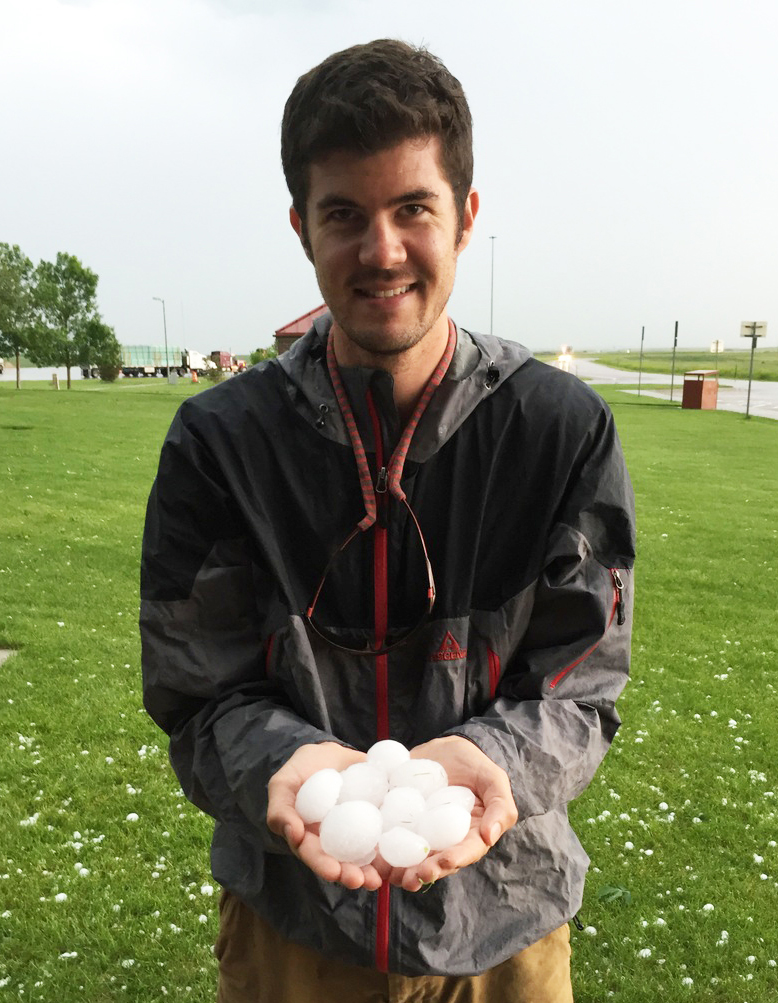 [Northern Illinois University meteorology professor Victor Gensini holds a collection of large hailstones after a June 2015 storm near Cheyenne, Wyoming. Credit: Victor Gensini, NIU]
During the summer, however, the GWO is unreliable as other smaller-scale meteorological processes tend to dominate local weather conditions.
“We will be testing the relationships this spring when severe weather season ramps up,” Gensini said.
“We’re starting to demonstrate more clearly a pathway to increase the lead time for severe weather forecasts, now with both hailstorms and tornadoes,” he added. “We keep adding cinderblocks to the methodology, and it’s slowly becoming robust.”
Edited for WeatherNation by Meteorologist Mace Michaels
[Northern Illinois University meteorology professor Victor Gensini holds a collection of large hailstones after a June 2015 storm near Cheyenne, Wyoming. Credit: Victor Gensini, NIU]
During the summer, however, the GWO is unreliable as other smaller-scale meteorological processes tend to dominate local weather conditions.
“We will be testing the relationships this spring when severe weather season ramps up,” Gensini said.
“We’re starting to demonstrate more clearly a pathway to increase the lead time for severe weather forecasts, now with both hailstorms and tornadoes,” he added. “We keep adding cinderblocks to the methodology, and it’s slowly becoming robust.”
Edited for WeatherNation by Meteorologist Mace Michaels
[New research finds a strong relationship between a wavy jet-stream pattern over the Pacific Ocean and severe U.S. hailstorms. Credit: Victor Gensini, NIU]
The study by Gensini and co-author John Allen of Central Michigan University was accepted for publication in the journal, Geophysical Research Letters.
Two years ago, Gensini led research on a method to predict the likelihood of U.S. tornado activity weeks in advance. Last year, of 26 long-range (two to three weeks) forecasts for increased, average or below average U.S. tornado activity, more than half were “spot on,” Gensini said. Most of the other predictions were only slightly off.
The new study is an extension of the tornado research, suggesting a similar method can be used in sub-seasonal forecasts of hailstorms. “There’s a high degree of correlation between environments that produce hail and tornadoes, but not all storms produce both hazards,” said Gensini, a professor in the NIU Department of Geographic and Atmospheric Sciences.
While the method would be used to forecast hail activity for the country in general, portions of Texas, Oklahoma, Arkansas, Kentucky, Missouri, Mississippi, Tennessee, Illinois and Indiana are most vulnerable to the phenomenon.
[This hailstone retrieved in June 2015, with a diameter of 4.75 inches, is the state record for Illinois. Photo from the State Climate Extremes Committee report that documented its occurrence and retrieval.]
Gensini and Allen examined hail observations from national storm data for the period of 1979 to 2016. They compared those events with changes in the Global Wind Oscillation (GWO) index, a collection of climate and weather information that measures atmospheric angular momentum, or the degree of waviness in the jet stream.
The GWO index has eight distinct phases. Four of those phases were reliable predictors of increased inland hail activity during peak storm seasons, according to the study.
“There is a strong connection between the GWO and U.S. hail frequency,” Allen said. “This relationship helps to understand what is driving hail variability, and explains to a large degree when we are likely to experience active and inactive periods during the spring and fall.”
[Northern Illinois University meteorology professor Victor Gensini holds a collection of large hailstones after a June 2015 storm near Cheyenne, Wyoming. Credit: Victor Gensini, NIU]
During the summer, however, the GWO is unreliable as other smaller-scale meteorological processes tend to dominate local weather conditions.
“We will be testing the relationships this spring when severe weather season ramps up,” Gensini said.
“We’re starting to demonstrate more clearly a pathway to increase the lead time for severe weather forecasts, now with both hailstorms and tornadoes,” he added. “We keep adding cinderblocks to the methodology, and it’s slowly becoming robust.”
Edited for WeatherNation by Meteorologist Mace MichaelsAll Weather News
More

More Storms for the East Through Monday
A low-pressure system that moved through the
3 Aug 2026 12:20 PM


After Reaching Category 5, Genevieve Weakens in the Pacific
PacificGenevieve formed last Friday south of
3 Aug 2026 12:30 AM

Flooding, Severe Storms Target the Midwest Again
After an active week of storms across the nor
1 Aug 2026 1:40 AM

Flooding Risk Increases as Heavy Rain Targets the Tri-State Area
Tuesday, heavy rainfall moved across the Nort
30 Jul 2026 12:25 AM