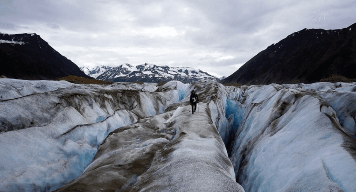
Researchers Use Satellite Data to Calculate Snow Depth in Mountain Ranges
Special Stories
20 Nov 2019 1:52 AM
[KU Leuven] Bioscience engineers at KU Leuven in Belgium have developed a method to measure the snow depth in all mountain ranges in the Northern Hemisphere using satellites. This technique makes it possible to study areas that cannot be accessed for local measurements, such as the Himalayas. The findings were published in Nature Communications.
“In Western Europe, we tend to associate snow with ski trips, outdoor fun, or traffic jams, which goes to show that the importance of snow is often underestimated,” says postdoctoral researcher Hans Lievens from the Department of Earth and Environmental Sciences at KU Leuven, who is the lead author of this study.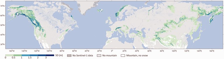 [Estimated snow depth from model. From KU Leuven]
“Each year, a fifth of the Northern Hemisphere gets covered in snow. More than one billion people rely on this snow for drinking water. Melting water is also very important for agriculture and the production of electricity. Furthermore, snow has a cooling effect on our climate by reflecting sunlight.”
As part of an international team, Lievens studied the snow depth in more than 700 mountain ranges in the Northern Hemisphere. The team used radar measurements provided by Sentinel-1, a satellite mission of the European Space Agency (ESA). The researchers analysed the data for the period between the Winter of 2016 up to and including the Summer of 2018.
“The Sentinel-1 mission specifically aims to observe the surface of the Earth,” says Lievens. “The satellite emits radar waves and, based on the reflection of these waves, we can calculate the snow depth. The ice crystals rotate the signal: the more rotated the waves, the more snow there is.”
[Estimated snow depth from model. From KU Leuven]
“Each year, a fifth of the Northern Hemisphere gets covered in snow. More than one billion people rely on this snow for drinking water. Melting water is also very important for agriculture and the production of electricity. Furthermore, snow has a cooling effect on our climate by reflecting sunlight.”
As part of an international team, Lievens studied the snow depth in more than 700 mountain ranges in the Northern Hemisphere. The team used radar measurements provided by Sentinel-1, a satellite mission of the European Space Agency (ESA). The researchers analysed the data for the period between the Winter of 2016 up to and including the Summer of 2018.
“The Sentinel-1 mission specifically aims to observe the surface of the Earth,” says Lievens. “The satellite emits radar waves and, based on the reflection of these waves, we can calculate the snow depth. The ice crystals rotate the signal: the more rotated the waves, the more snow there is.”
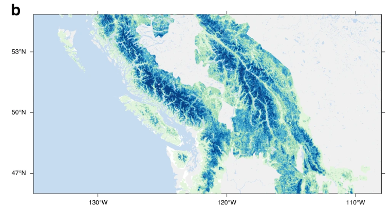 [Monthly snow depth retrieved by Sentinel-1 in the western US and Canada.]
Weather and climate models
Existing calculations of snow depth are often based on local measurements, but in many cases, these offer an inaccurate or incomplete picture. In the Himalayas, for instance, in-situ measurements are almost impossible due to the extreme circumstances. Thanks to the satellite data, it is now possible to observe mountain areas that are difficult or impossible to access. The absolute peak in the measurements pertains to the west of Canada: the Coast Mountains have a snow volume of 380 cubic kilometres. That is over 100 cubic kilometres more than local measurements indicate. Also standing out are the snowy areas in eastern Russia, especially in Siberia and the Kamchatka Peninsula. In Europe, the Scandinavian mountains and the Alps are the areas with the largest volumes of snow.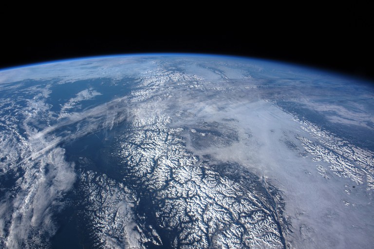 [The Coast Mountains (Canada/US) as seen from space. From NASA]
“Based on these first measurements, we cannot estimate the impact of climate change yet, but this should become possible in the long run,” says Lievens. “We will be able to monitor more accurately how the volume of snow evolves and when the melting season takes place. Our method may also help to improve water distribution management and to assess the flood risk in certain areas.”
[The Coast Mountains (Canada/US) as seen from space. From NASA]
“Based on these first measurements, we cannot estimate the impact of climate change yet, but this should become possible in the long run,” says Lievens. “We will be able to monitor more accurately how the volume of snow evolves and when the melting season takes place. Our method may also help to improve water distribution management and to assess the flood risk in certain areas.”
Winter expedition
This winter, Hans Lievens and doctoral student Isis Brangers are travelling to the Rocky Mountains in Idaho to further study the technique. “We don’t fully understand yet what physically happens when the radar waves reflect in the snowpack. Various elements may influence the signal: the shape and size of the ice crystals, humidity, the different layers of snow, and so on. By continuing to measure and study snow locally, we should be able to refine the method.” “In January and February, we’ll also take part in the NASA SnowEx campaign. An international team of scientists is examining the snow conditions at Grand Mesa, a large plateau in Colorado with a 3500-metre altitude. We’ll be testing various new techniques and sensors there to calculate the snow mass. It’s promising to be a very intensive but especially informative time.”All Weather News
More

Flooding, Severe Storms Target the Midwest Again
After an active week of storms across the nor
1 Aug 2026 1:40 AM


After Reaching Category 5, Genevieve Weakens in the Pacific
PacificFausto is now a post-tropical cyclone.
31 Jul 2026 1:30 AM

Flooding Risk Increases as Heavy Rain Targets the Tri-State Area
Tuesday, heavy rainfall moved across the Nort
30 Jul 2026 12:25 AM

Severe Weather: Energy From the Midwest Now in the Southeast
UPPER MIDWEST - Through Monday, dangerous tor
29 Jul 2026 10:30 PM