Satellite Estimates of Tropical Rains that Produced Flooding in Texas Last Week
Special Stories
25 Jun 2018 8:36 AM
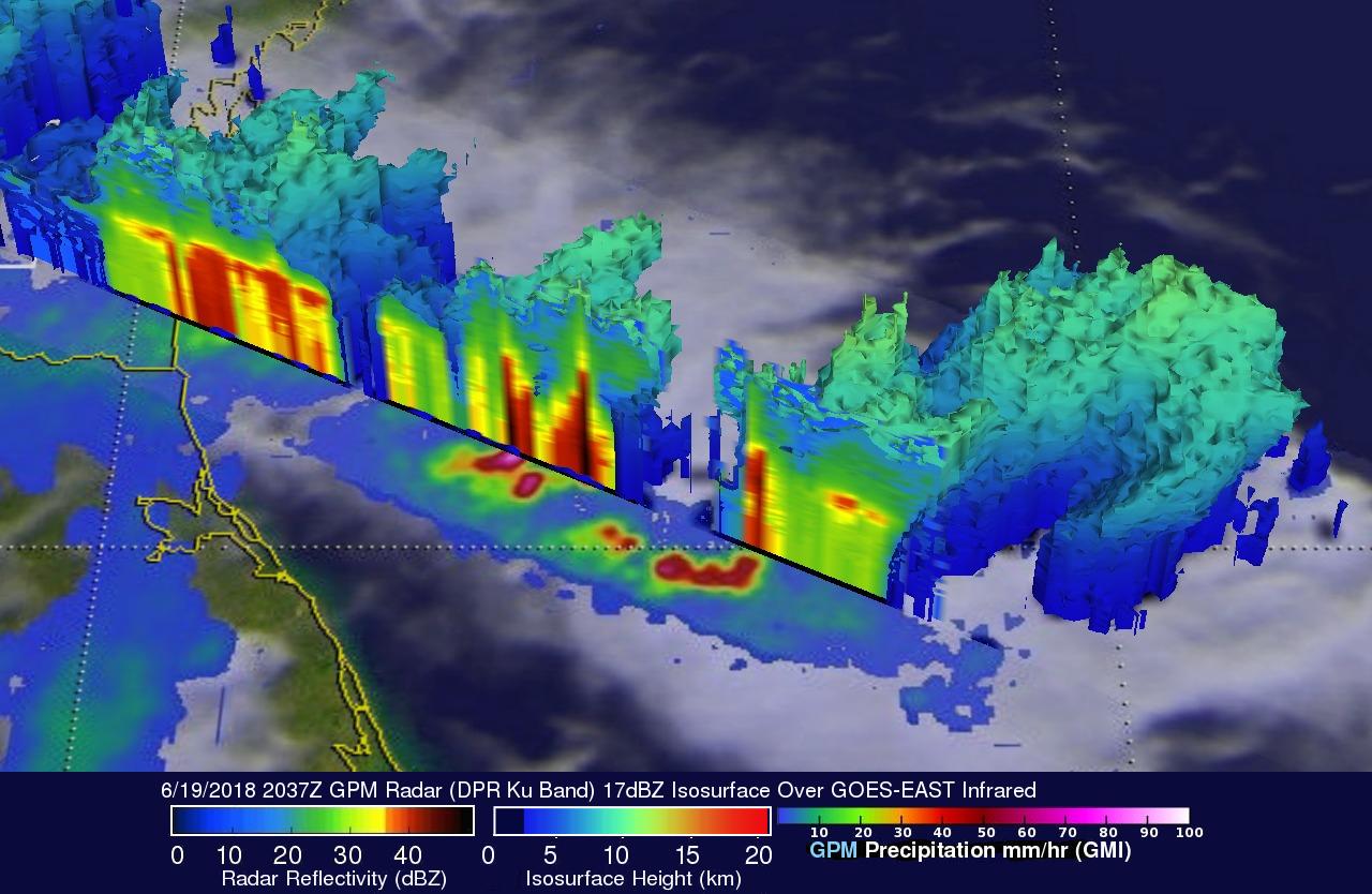
[In this 3-D image from last week, the GPM core observatory satellite probed powerful storms that were dropping rain at a rate of 3.5 inches per hour in the southern Texas coast. GPM found some powerful storms were reaching altitudes above 7.75 miles dropping rain at a rate of 3.5 inches per hour. Credits: NASA/JAXA, Hal Pierce]
From NASA
While Tropical Storm Bud was lashing parts of western Mexico and causing flooding that extended into the American Southwest, a tropical disturbance was spinning over the Gulf of Mexico and straddling southeastern Texas. This system sat in place for almost a week bringing extremely heavy rainfall and causing a flash flood emergency. More than 15 inches of rain fell in Hidalgo County, Texas between June 18 and 22.
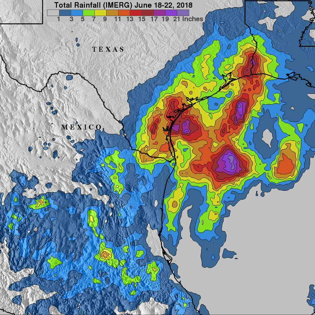 [IMERG data shows extreme flooding in parts of Texas from low pressure tropical disturbance. IMERG estimates indicated that the heaviest rainfall occurred in the northwestern Gulf of Mexico where over 21 inches of rain fell. IMERG data also indicated that more than 9 inches fell in large areas from south Texas to western Louisiana. This extreme rainfall resulted in the worst Texas flooding since hurricane Harvey in August 2017. Credits: NASA]
With streets being overrun by rain waters, the Governor of Texas declared a state of emergency for six counties in south Texas Thursday afternoon, June 21, two days after rain began. The heaviest rain from the system had ended by Friday morning, June 22. Local Emergency Management and Department of Transportation continued to report residual flooding occurring across the warned area. Multiple roads remained impassable this weekend due to ongoing flooding from resent heavy rainfall that ranged from 10 to 14 inches over the past few days.
https://www.youtube.com/watch?time_continue=9&v=oORB781sHJo
Integrated Multi satellitE Retrievals for GPM (IMERG) data were used in this space based estimate of rainfall accumulation over Texas and northern Mexico during the period from June 18 to 22. These IMERG estimates were derived from various satellite space-borne passive microwave sensors, including the GPM (Global Precipitation Measurement mission) satellite's Microwave Imager (GMI). GPM is a joint mission between NASA and the Japan Aerospace Exploration Agency, JAXA.
IMERG estimates showed extremely heavy precipitation fell over southern Texas and the northwestern Gulf of Mexico. IMERG estimates indicated that the heaviest rainfall occurred in the northwestern Gulf of Mexico where over 21 inches of rain fell. IMERG data also indicated that more than 9 inches fell in large areas from south Texas to western Louisiana. This extreme rainfall resulted in the worst Texas flooding since Hurricane Harvey in August 2017.
Edited for WeatherNation by Meteorologist Mace Michaels
[IMERG data shows extreme flooding in parts of Texas from low pressure tropical disturbance. IMERG estimates indicated that the heaviest rainfall occurred in the northwestern Gulf of Mexico where over 21 inches of rain fell. IMERG data also indicated that more than 9 inches fell in large areas from south Texas to western Louisiana. This extreme rainfall resulted in the worst Texas flooding since hurricane Harvey in August 2017. Credits: NASA]
With streets being overrun by rain waters, the Governor of Texas declared a state of emergency for six counties in south Texas Thursday afternoon, June 21, two days after rain began. The heaviest rain from the system had ended by Friday morning, June 22. Local Emergency Management and Department of Transportation continued to report residual flooding occurring across the warned area. Multiple roads remained impassable this weekend due to ongoing flooding from resent heavy rainfall that ranged from 10 to 14 inches over the past few days.
https://www.youtube.com/watch?time_continue=9&v=oORB781sHJo
Integrated Multi satellitE Retrievals for GPM (IMERG) data were used in this space based estimate of rainfall accumulation over Texas and northern Mexico during the period from June 18 to 22. These IMERG estimates were derived from various satellite space-borne passive microwave sensors, including the GPM (Global Precipitation Measurement mission) satellite's Microwave Imager (GMI). GPM is a joint mission between NASA and the Japan Aerospace Exploration Agency, JAXA.
IMERG estimates showed extremely heavy precipitation fell over southern Texas and the northwestern Gulf of Mexico. IMERG estimates indicated that the heaviest rainfall occurred in the northwestern Gulf of Mexico where over 21 inches of rain fell. IMERG data also indicated that more than 9 inches fell in large areas from south Texas to western Louisiana. This extreme rainfall resulted in the worst Texas flooding since Hurricane Harvey in August 2017.
Edited for WeatherNation by Meteorologist Mace MichaelsAll Weather News
More
Flooding, Severe Storms Target the Midwest Again
After an active week of storms across the nor
31 Jul 2026 4:15 PM


After Reaching Category 5, Genevieve Weakens in the Pacific
PacificFausto is now a post-tropical cyclone.
31 Jul 2026 1:30 AM

Flooding Risk Increases as Heavy Rain Targets the Tri-State Area
Tuesday, heavy rainfall moved across the Nort
30 Jul 2026 12:25 AM

Severe Weather: Energy From the Midwest Now in the Southeast
UPPER MIDWEST - Through Monday, dangerous tor
29 Jul 2026 10:30 PM