Severe Weather Threat Continues On Saturday

Special Stories
6 Apr 2018 9:17 PM
Friday was a very active severe weather day in parts of the South. Texas, Louisiana, and Mississippi were all hit hard by powerful storms. Damaging straight light winds, hail, torrential rain, and numerous tornadoes, all came into play. But the severe weather threat is not over. The storm system that caused problems on Friday will be shifting to the east on Saturday. More strong storms are possible, particularly across southern Georgia, South Carolina, and northern Florida.
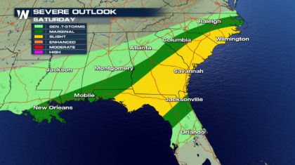
The Storm Prediction Center in Norman Oklahoma issued their severe weather outlook for Saturday. A Marginal risk is outlined in the dark green shaded area. New Orleans, Mobile, Augusta, Columbia, Jacksonville, and Raleigh are all included in this area. There is a 5 percent chance of severe weather at any given location in the Marginal risk area. The Slight risk area is the yellow shaded area. There is a 15 percent chance of severe weather at any given location in the Slight risk area. Cities include Savannah, Charleston, Myrtle Beach, and Wilmington.
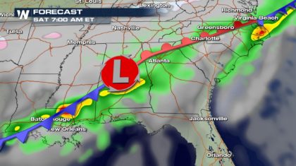
 Early Saturday morning, the strongest storms will be in southern Louisiana, and possibly central Alabama. Baton Rouge, New Orleans, Mobile, and Pensacola could all be in the mix for strong to severe storms.
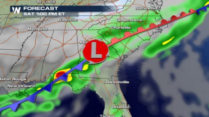
 By Early afternoon, the front will stretch from the Gulf Coast, through central Georgia and South Carolina. The Masters golf tournament is currently underway in Augusta, Georgia. Strong to severe storms could impact play on Saturday. Even cloud to ground lightning could halt play, forcing patrons to clear the course. Columbia, South Carolina could also be impacted by the storm system during this time.
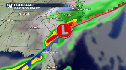
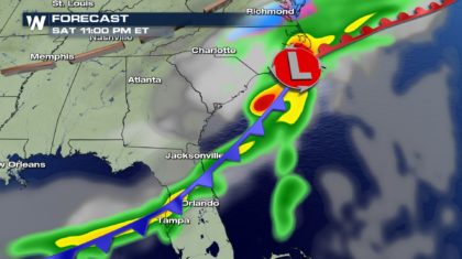
 By early evening, coastal Georgia and coastal South Carolina will see the brunt of the storms. Very heavy rain and strong storms will be possible in Savannah, Charleston, Myrtle Beach, and Wilmington.
 By late evening, most of the activity will move offshore with the front. However, eastern North Carolina and central Florida could still be under the influence of heavy rain and storms.
 Overall, the primary severe threat on Saturday will be damaging wind gusts. However, a brief tornado or two will also be possible. Hail will not be as likely as it was on Friday, but some hail could certainly form within a few storms.
Stay tuned to WeatherNation on Saturday for the latest developments on this severe weather threat. We will be tracking the storms throughout the day.
For WeatherNation: Meteorologist Matt Monroe
Overall, the primary severe threat on Saturday will be damaging wind gusts. However, a brief tornado or two will also be possible. Hail will not be as likely as it was on Friday, but some hail could certainly form within a few storms.
Stay tuned to WeatherNation on Saturday for the latest developments on this severe weather threat. We will be tracking the storms throughout the day.
For WeatherNation: Meteorologist Matt Monroe
Early Saturday morning, the strongest storms will be in southern Louisiana, and possibly central Alabama. Baton Rouge, New Orleans, Mobile, and Pensacola could all be in the mix for strong to severe storms.
By Early afternoon, the front will stretch from the Gulf Coast, through central Georgia and South Carolina. The Masters golf tournament is currently underway in Augusta, Georgia. Strong to severe storms could impact play on Saturday. Even cloud to ground lightning could halt play, forcing patrons to clear the course. Columbia, South Carolina could also be impacted by the storm system during this time.
By early evening, coastal Georgia and coastal South Carolina will see the brunt of the storms. Very heavy rain and strong storms will be possible in Savannah, Charleston, Myrtle Beach, and Wilmington.
By late evening, most of the activity will move offshore with the front. However, eastern North Carolina and central Florida could still be under the influence of heavy rain and storms.
Overall, the primary severe threat on Saturday will be damaging wind gusts. However, a brief tornado or two will also be possible. Hail will not be as likely as it was on Friday, but some hail could certainly form within a few storms.
Stay tuned to WeatherNation on Saturday for the latest developments on this severe weather threat. We will be tracking the storms throughout the day.
For WeatherNation: Meteorologist Matt MonroeAll Weather News
More
East Gears Up for Stormy, Wet Weekend
A low pressure system crashing through the Mi
1 Aug 2026 11:35 AM


Flooding, Severe Storms Target the Midwest Again
After an active week of storms across the nor
1 Aug 2026 1:40 AM


After Reaching Category 5, Genevieve Weakens in the Pacific
PacificFausto is now a post-tropical cyclone.
31 Jul 2026 1:30 AM

Flooding Risk Increases as Heavy Rain Targets the Tri-State Area
Tuesday, heavy rainfall moved across the Nort
30 Jul 2026 12:25 AM

Severe Weather: Energy From the Midwest Now in the Southeast
UPPER MIDWEST - Through Monday, dangerous tor
29 Jul 2026 10:30 PM