Soggy Start to the Work Week in the Northeast
Special Stories
10 Jun 2019 4:38 AM
The focus of widespread heavy rain shifts, bringing a persistently soggy forecast from the Virginias through New England.
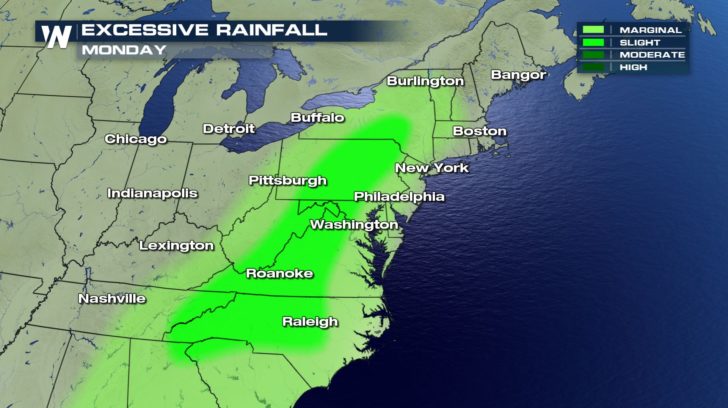
The Weather Prediction Center has highlighted spots from the Central Appalachians to New York under a risk of excessive rainfall. Be prepared for ponding and flooding on roadways, low-lying areas, or spots with poor drainage. Storms could produce 1 to 2 inch per hour rainfall rates.
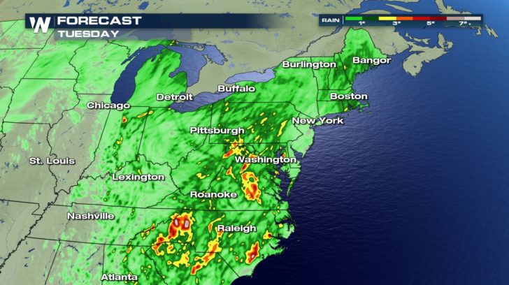
 A cold front has moved in from the Great Lakes region. Moisture will increase out ahead of this front thanks to a southerly flow. Dew points will climb as moisture increases in the atmosphere. Eventually all of this moisture will get dumped out in the form of heavy rain.
https://gph.is/g/4DAJ6gw
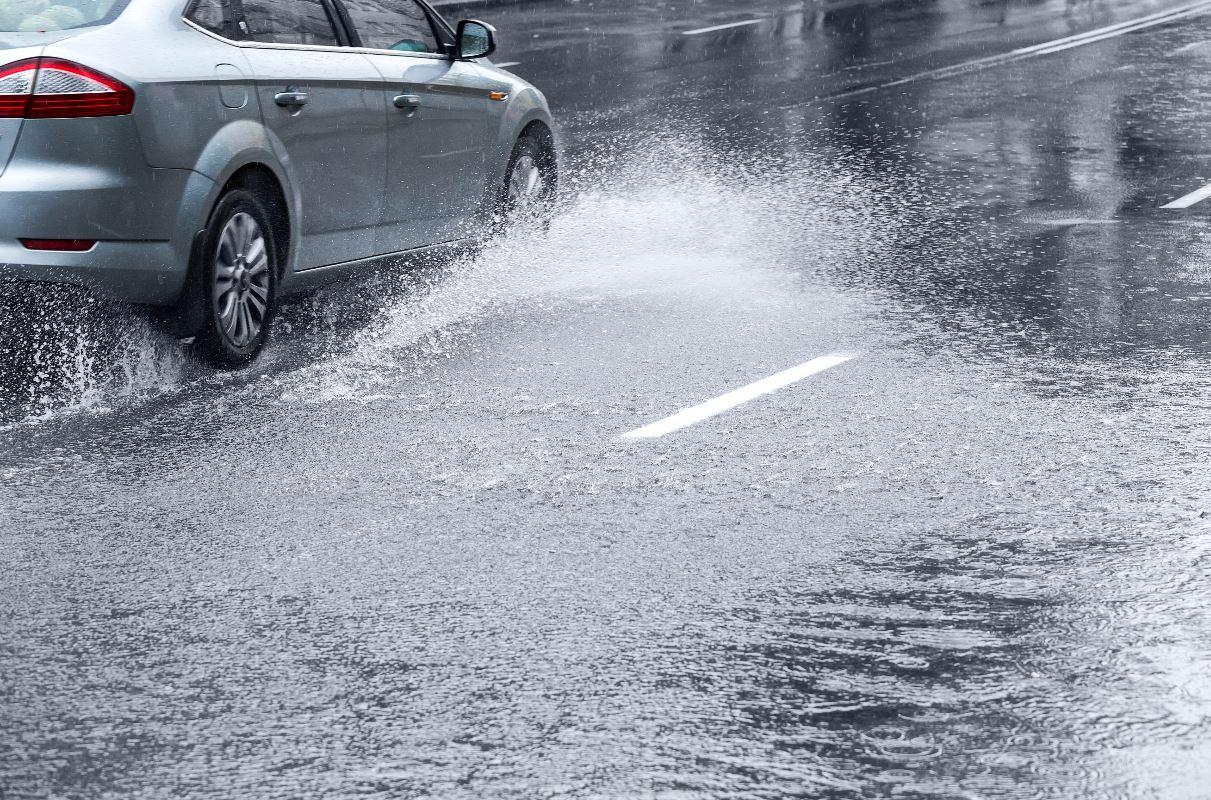
Slow storm motion will add to the threat of flooding. Widespread rainfall looks to add up to a couple inches. Isolated spots could pick up more than 3 inches of rain in just the next couple of days. Be on the lookout for flooded roadways. If you encounter standing or moving water while driving, be sure to "Turn Around, and Don't Drown." Click here for more on the Hazards of Floodwaters.
A cold front has moved in from the Great Lakes region. Moisture will increase out ahead of this front thanks to a southerly flow. Dew points will climb as moisture increases in the atmosphere. Eventually all of this moisture will get dumped out in the form of heavy rain.
https://gph.is/g/4DAJ6gw
Slow storm motion will add to the threat of flooding. Widespread rainfall looks to add up to a couple inches. Isolated spots could pick up more than 3 inches of rain in just the next couple of days. Be on the lookout for flooded roadways. If you encounter standing or moving water while driving, be sure to "Turn Around, and Don't Drown." Click here for more on the Hazards of Floodwaters.
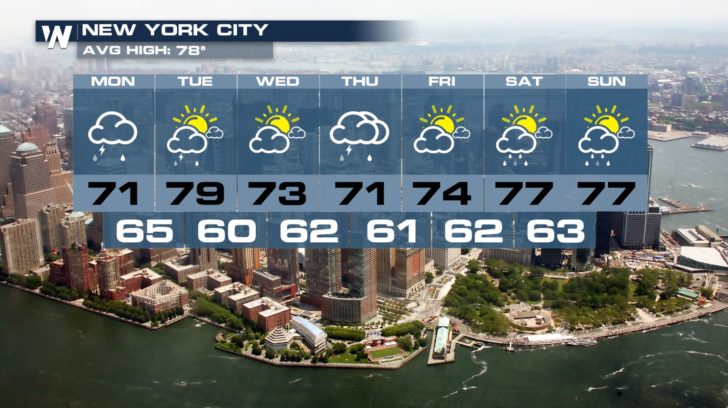
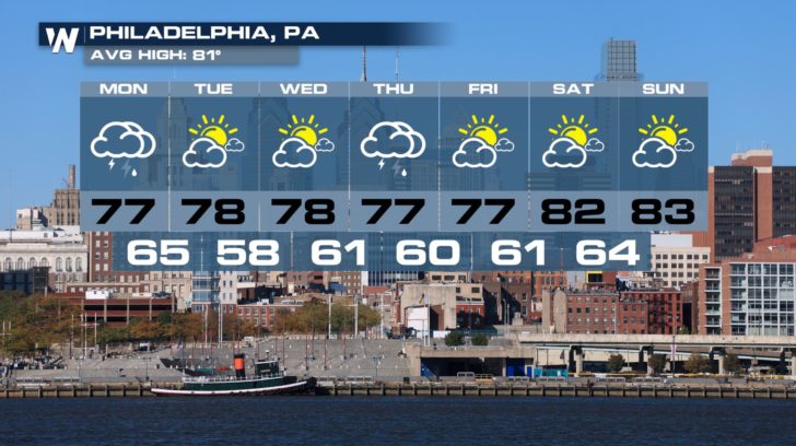
 Looks like we're going to need the rain gear for much of the next week. Showers and thunderstorms remain in the forecast through Friday in several spots.
 Stay dry and stick with WeatherNation for continued updates online and on-air.
Meteorologist Viki Knapp
Stay dry and stick with WeatherNation for continued updates online and on-air.
Meteorologist Viki Knapp
A cold front has moved in from the Great Lakes region. Moisture will increase out ahead of this front thanks to a southerly flow. Dew points will climb as moisture increases in the atmosphere. Eventually all of this moisture will get dumped out in the form of heavy rain.
https://gph.is/g/4DAJ6gw
Slow storm motion will add to the threat of flooding. Widespread rainfall looks to add up to a couple inches. Isolated spots could pick up more than 3 inches of rain in just the next couple of days. Be on the lookout for flooded roadways. If you encounter standing or moving water while driving, be sure to "Turn Around, and Don't Drown." Click here for more on the Hazards of Floodwaters.
Looks like we're going to need the rain gear for much of the next week. Showers and thunderstorms remain in the forecast through Friday in several spots.
Stay dry and stick with WeatherNation for continued updates online and on-air.
Meteorologist Viki KnappAll Weather News
More

East Gears Up for Stormy, Wet Weekend
A low pressure system crashing through the Mi
1 Aug 2026 9:15 PM


Flooding, Severe Storms Target the Midwest Again
After an active week of storms across the nor
1 Aug 2026 1:40 AM

After Reaching Category 5, Genevieve Weakens in the Pacific
PacificFausto is now a post-tropical cyclone.
31 Jul 2026 1:30 AM

Flooding Risk Increases as Heavy Rain Targets the Tri-State Area
Tuesday, heavy rainfall moved across the Nort
30 Jul 2026 12:25 AM

Severe Weather: Energy From the Midwest Now in the Southeast
UPPER MIDWEST - Through Monday, dangerous tor
29 Jul 2026 10:30 PM