Spring outlook: More storms, heat for eastern U.S.?
Special Stories
25 Mar 2020 5:34 PM
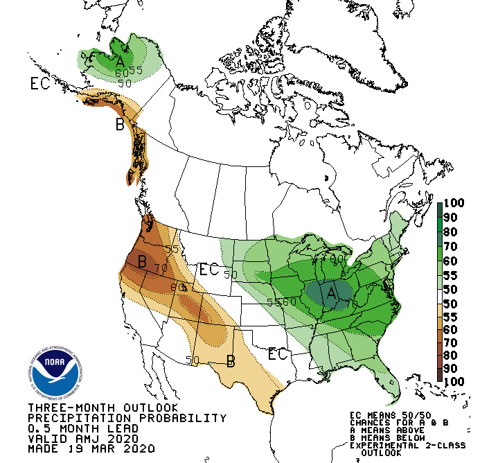
The Climate Prediction Center's (CPC) new 90-day outlook could feature a possible continuation of what we've seen so far this year: more warmth and more wet weather for the eastern half of the country.
According to the CPC outlook for April, May and June, the Midwest and the East Coast could both be in for more warm and wet weather. That's been a pattern that's dominated the opening two-plus months of 2020, and the CPC outlook hints that trend could continue through the spring months.
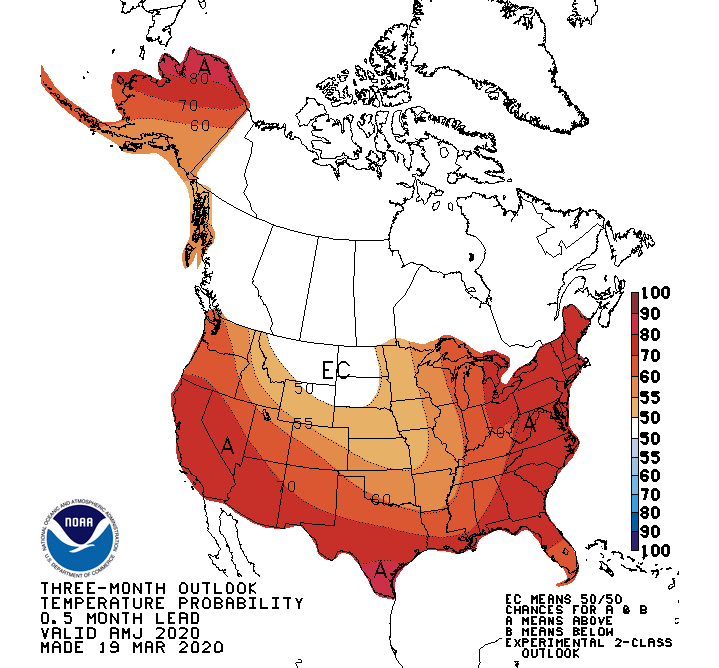
 This outlook could be especially significant for two key reasons. First, and potentially most importantly, this wetter and warmer outlook coincides with the heart of severe weather season, and in the prime locations for it. April, May and June typically are the top-three months for severe weather and tornadoes, and warm, wet weather often helps fuel those stronger storms.
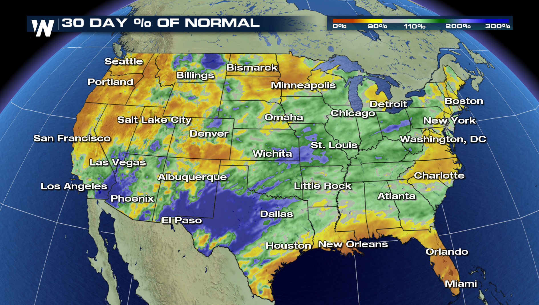
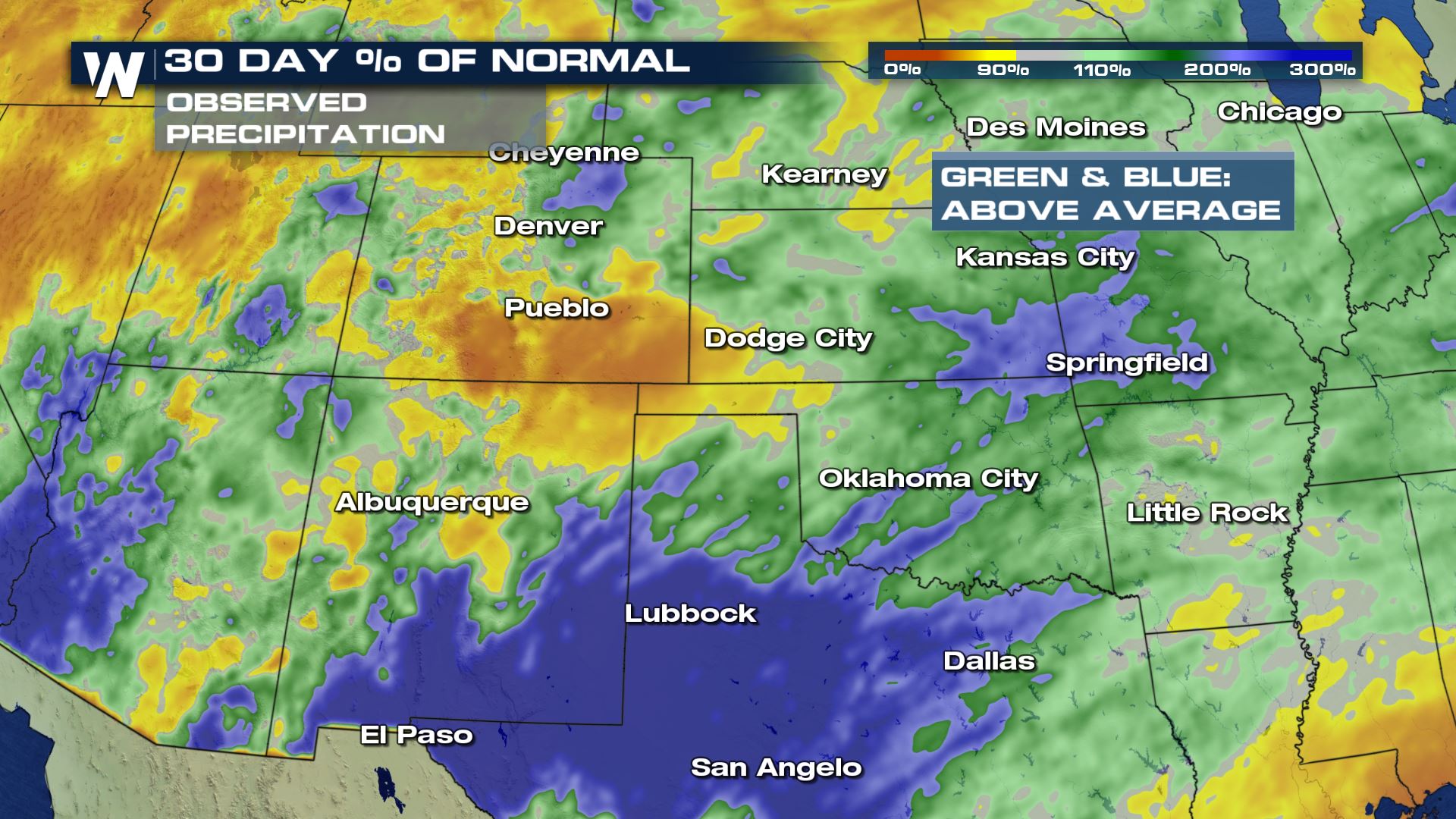
The other key takeaway from this is the possible exacerbation of the existing flood concerns across the southeastern U.S. So far this year, most of the southeast is running well above average in terms of its total precipitation. That trend has mostly continued over the last 30 days, though parts of the Gulf Coast and Florida have been a tad drier.
This outlook could be especially significant for two key reasons. First, and potentially most importantly, this wetter and warmer outlook coincides with the heart of severe weather season, and in the prime locations for it. April, May and June typically are the top-three months for severe weather and tornadoes, and warm, wet weather often helps fuel those stronger storms.
The other key takeaway from this is the possible exacerbation of the existing flood concerns across the southeastern U.S. So far this year, most of the southeast is running well above average in terms of its total precipitation. That trend has mostly continued over the last 30 days, though parts of the Gulf Coast and Florida have been a tad drier.
 This also coincides with the April monthly outlook from the CPC, which also leans wetter and warmer for the eastern third of the country.
On the reverse side of things, it also could trend warmer - but drier - for the western third of the country, where moderate and severe drought exists in parts of the Four Corners and Southwest states. The Sierra Nevada mountains in California and Nevada are running at only about half of their typical season-to-date snowpack levels. If this outlook verifies, it could maintain or worsen existing drought conditions in this part of the country.
Stay with WeatherNation for the latest on this spring's outlook, and for more on long-range forecast trends.
This also coincides with the April monthly outlook from the CPC, which also leans wetter and warmer for the eastern third of the country.
On the reverse side of things, it also could trend warmer - but drier - for the western third of the country, where moderate and severe drought exists in parts of the Four Corners and Southwest states. The Sierra Nevada mountains in California and Nevada are running at only about half of their typical season-to-date snowpack levels. If this outlook verifies, it could maintain or worsen existing drought conditions in this part of the country.
Stay with WeatherNation for the latest on this spring's outlook, and for more on long-range forecast trends.
This outlook could be especially significant for two key reasons. First, and potentially most importantly, this wetter and warmer outlook coincides with the heart of severe weather season, and in the prime locations for it. April, May and June typically are the top-three months for severe weather and tornadoes, and warm, wet weather often helps fuel those stronger storms.
The other key takeaway from this is the possible exacerbation of the existing flood concerns across the southeastern U.S. So far this year, most of the southeast is running well above average in terms of its total precipitation. That trend has mostly continued over the last 30 days, though parts of the Gulf Coast and Florida have been a tad drier.
This also coincides with the April monthly outlook from the CPC, which also leans wetter and warmer for the eastern third of the country.
On the reverse side of things, it also could trend warmer - but drier - for the western third of the country, where moderate and severe drought exists in parts of the Four Corners and Southwest states. The Sierra Nevada mountains in California and Nevada are running at only about half of their typical season-to-date snowpack levels. If this outlook verifies, it could maintain or worsen existing drought conditions in this part of the country.
Stay with WeatherNation for the latest on this spring's outlook, and for more on long-range forecast trends.All Weather News
More
Tropical Storm Vance Forms In The Pacific
Isaias ended the late-season streak of no hur
22 Oct 2026 3:20 PM

Flooding & Severe Storms Target the Southwest
A strong trough of low pressure is moving ons
22 Oct 2026 12:35 PM

Warmer Than Average: Above-Normal Temperatures Across the Central U.S. This Week
WHAT TO EXPECTA ridge of high pressure will b
22 Oct 2026 12:30 PM

Sub-Tropical Josephine Becomes Tenth Atlantic Named Storm
SETUPAn upper-level low broke off from the fl
22 Oct 2026 1:40 AM

Several Fires Break Out in SoCal Last Week Amid Santa Ana Wind Event
Santa Ana winds helped several fires grow qui
19 Oct 2026 1:25 PM

Another Cold Morning Before Things Warm Back Up
Across portions of the Ohio Valley through th
19 Oct 2026 10:15 AM

Severe Risk Diminishing Saturday Morning for the Northeast
Severe Storm PotentialSevere risk is decreasi
16 Oct 2026 10:20 AM