Tornadoes Rip Through Central, Southern U.S.
Special Stories
2 Dec 2018 12:05 AM
Severe storms fired up both Friday and the 1st day of December on Saturday. Dangerous severe storms brought damaging wind, hail, and tornadoes across the southern and central U.S. both days.
Friday, November 30
On Friday, storms started to fire in the afternoon, continuing through the overnight timeframe. Numerous tornado warnings were issued for storms from Texas to Missouri. The National Weather Service continued storm surveys through into the weekend. At least 3 tornadoes occurred Friday, all in Oklahoma and Missouri. Sadly, at least 1 death was reported as a result of the storms, according to the local Aurora, MO Police Department. One of the longest lasting tornadic storms of the event tore a path of damage at least 25 miles long through Sequoyah county, Oklahoma, where the National Weather Service confirmed an EF-2 tornado. Winds were estimated to be between 115 to 125 mph. https://twitter.com/WeatherNation/status/1068925696678850560 https://twitter.com/WeatherNation/status/1068931036724097024Saturday, December 1
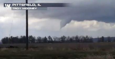
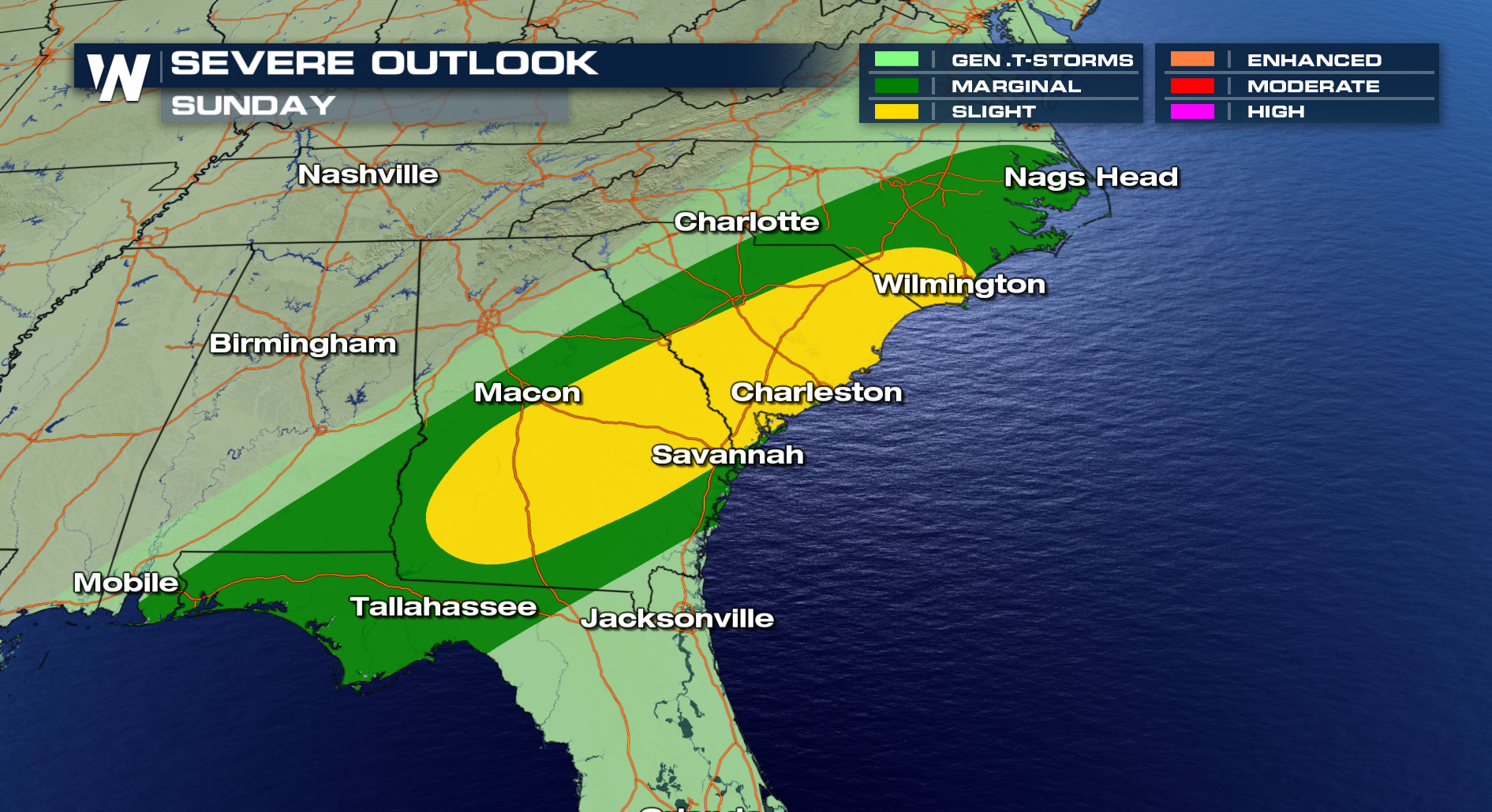
December started on an intense note, especially for Illinois where nearly 2 dozen tornadoes were reported across the state. Some severe storms carried over from the previous night, others fired up for a second round during he afternoon as temperatures and moisture climbed. Tornadoes ripped through several communities, causing damage across the 'The Prairie State'. Storm surveys are expected to continue through Sunday in some areas by the local NWS office in Lincoln, IL. The storms to be surveyed include a possible tornado near Taylorville, IL, and the other in west-central Illinois near the Illinois River. WeatherNation obtained many visuals of the storms. https://twitter.com/WeatherNation/status/1068997182370459648 https://twitter.com/WeatherNation/status/1069059110694342656 https://twitter.com/WeatherNation/status/1069062221949333508 *correction to above image: Credit: Brian Johnston* https://twitter.com/WeatherNation/status/1069043811282673664 *correction to above image: Credit: Brian Johnston* The threat of severe weather continues into Sunday for parts of the southeastern U.S. including areas from the Florida Panhandle to the Carolinas. Stay with WeatherNation as we continue to track the severe weather risk ahead.
All Weather News
More
East Gears Up for Stormy, Wet Weekend
A low pressure system crashing through the Mi
1 Aug 2026 6:15 PM


Flooding, Severe Storms Target the Midwest Again
After an active week of storms across the nor
1 Aug 2026 1:40 AM

After Reaching Category 5, Genevieve Weakens in the Pacific
PacificFausto is now a post-tropical cyclone.
31 Jul 2026 1:30 AM

Flooding Risk Increases as Heavy Rain Targets the Tri-State Area
Tuesday, heavy rainfall moved across the Nort
30 Jul 2026 12:25 AM

Severe Weather: Energy From the Midwest Now in the Southeast
UPPER MIDWEST - Through Monday, dangerous tor
29 Jul 2026 10:30 PM