Using Temperatures to Improve Streamflow Forecasts
Special Stories
26 Feb 2018 2:59 PM
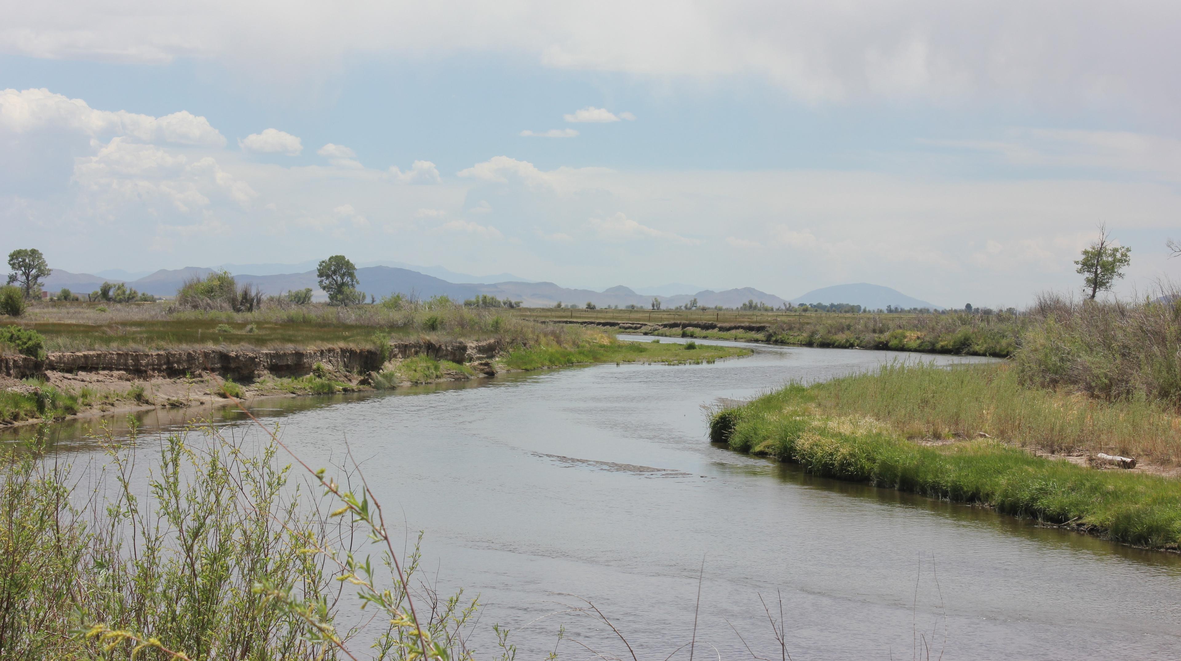
[Rio Grande River from USFWS Mountain Prairie via CC by 2.0 from Flickr]
From UCAR
Adding temperature predictions into seasonal streamflow forecasts in the U.S. Southwest could increase the accuracy of those forecasts, according to a new study that analyzed historical conditions in the headwaters of the Colorado and Rio Grande rivers.
Many rivers in the western United States are fed by melting snow in the spring and summer. Regional water managers depend on seasonal water supply forecasts that estimate the amount of runoff the snowpack will yield to determine how much water to allocate to farmers and ranchers, city residents, and other users.
These forecasts, which are based on snowpack measurements taken in the winter and spring, tend to assume that the climate is stable and that the relationship between the amount of snowpack and the amount of runoff is also stable.
But a recent study by scientists at the National Center for Atmospheric Research (NCAR), the National Oceanic and Atmospheric Administration (NOAA), and the Bureau of Reclamation found that warmer temperatures reduce the amount of meltwater that actually makes it into a stream, a finding that highlights the importance of accounting for changing climate conditions when forecasting streamflow.
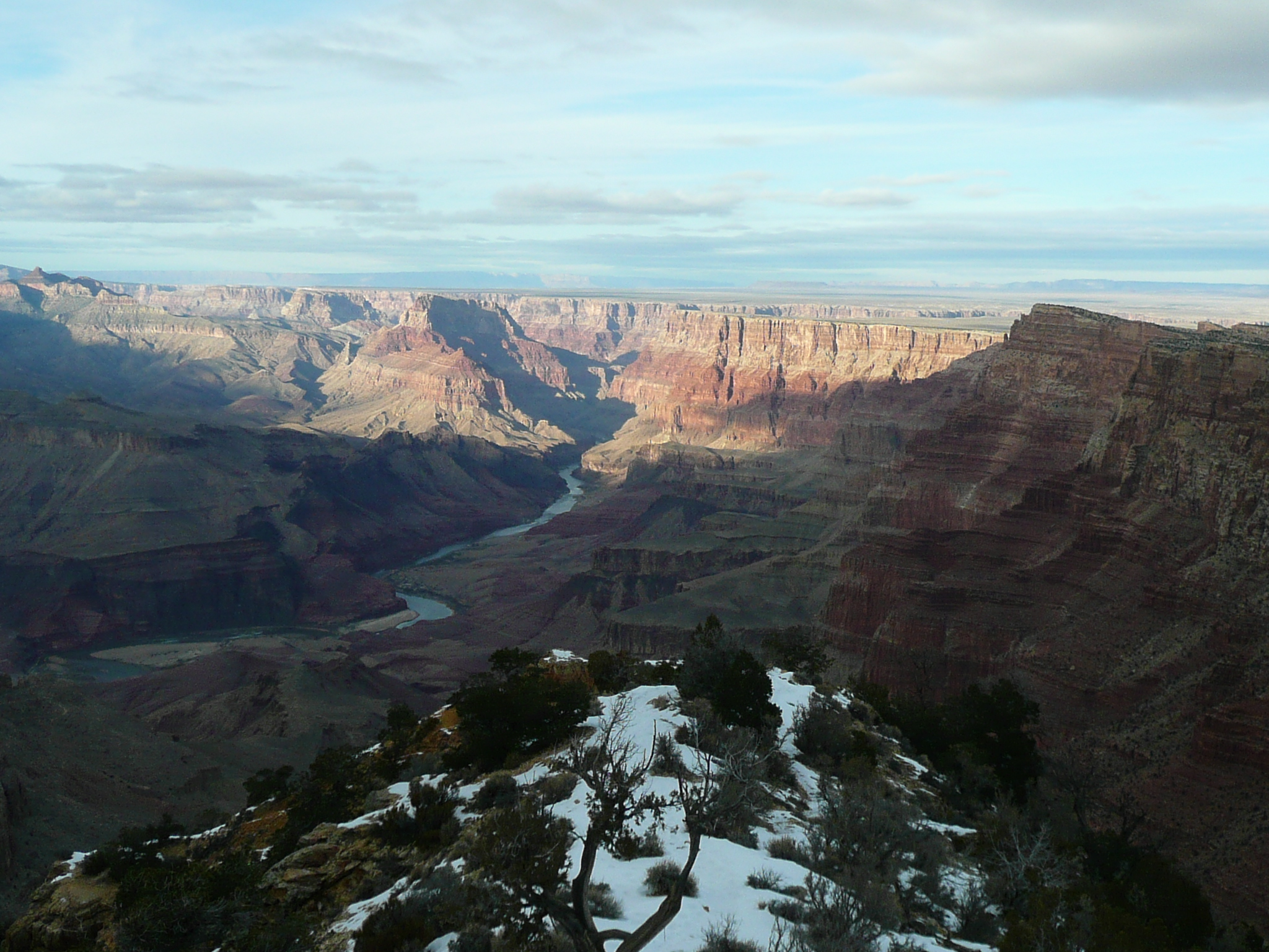 [Colorado River by Flavio Ensiki via CC by 2.0 from Flickr]
Building on this work, scientists at NCAR tested whether incorporating seasonal temperature predictions into statistical streamflow forecasting models could improve their accuracy. The temperature predictions reflect the recent warming trend as well as whether the months after the forecast date are likely to be warmer or colder than this trend. Results of the new study were published in the journal Geophysical Research Letters.
"Adding temperature predictions into streamflow forecasts will not only improve the information that water managers have today, but it also has the potential to mitigate some of the loss of predictability that we now expect in the future, as the climate continues to warm," said NCAR scientist Flavio Lehner, who co-led the study with NCAR scientist Andy Wood.
[Colorado River by Flavio Ensiki via CC by 2.0 from Flickr]
Building on this work, scientists at NCAR tested whether incorporating seasonal temperature predictions into statistical streamflow forecasting models could improve their accuracy. The temperature predictions reflect the recent warming trend as well as whether the months after the forecast date are likely to be warmer or colder than this trend. Results of the new study were published in the journal Geophysical Research Letters.
"Adding temperature predictions into streamflow forecasts will not only improve the information that water managers have today, but it also has the potential to mitigate some of the loss of predictability that we now expect in the future, as the climate continues to warm," said NCAR scientist Flavio Lehner, who co-led the study with NCAR scientist Andy Wood.
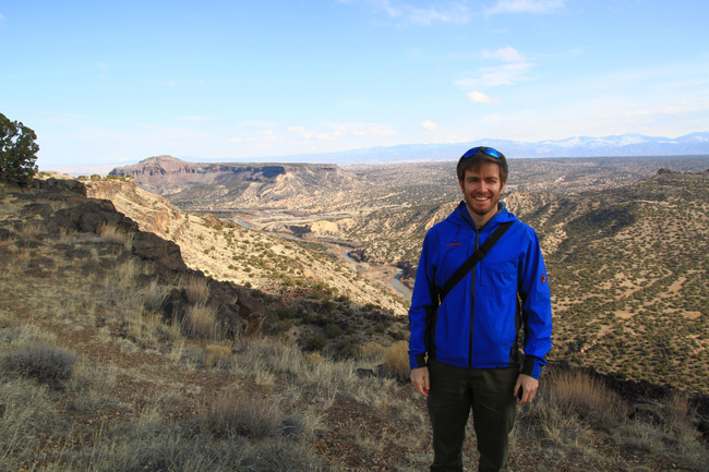 [NCAR scientist Flavio Lehner in the upper Rio Grande River watershed near Los Alamos, New Mexico. (Photo courtesy Flavio Lehner.)]
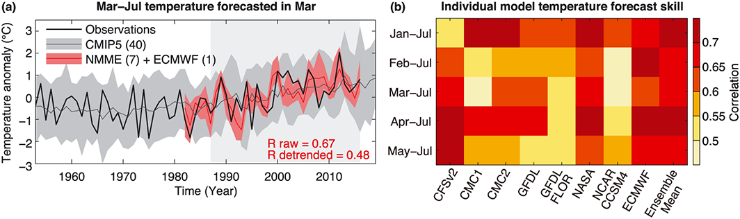 [(a) March–July mean temperature anomalies relative to 1982–2016 from observations, 40 CMIP5 models, and seasonal prediction models (NMME + ECMWF), averaged over the box indicated in Figure 1a. The red line is the mean across NMME-ECMWF models, the gray line is the mean across CMIP5 models, and the black line is observations. Shading indicates the 5–95% range. (b) Correlation between observed and forecasted temperature for different temperature targets and seasonal prediction models for 1982–2016. Forecasts are initialized at the start of each predicted period. All correlations are significant at 95% confidence.]
The team found that incorporating temperature predictions improved the accuracy of seasonal streamflow forecasts at the majority of river gauges across the headwaters of both basins. The amount of improvement varied between about 1 percent and 10 percent, averaged across the basins.
"We think that model-based temperature predictions could be used to improve water supply forecasts in other watersheds that rely on runoff from snowpack — across the western United States and in other parts of the world," Lehner said "But the degree of improvement will certainly depend on the individual area."
[(a) March–July mean temperature anomalies relative to 1982–2016 from observations, 40 CMIP5 models, and seasonal prediction models (NMME + ECMWF), averaged over the box indicated in Figure 1a. The red line is the mean across NMME-ECMWF models, the gray line is the mean across CMIP5 models, and the black line is observations. Shading indicates the 5–95% range. (b) Correlation between observed and forecasted temperature for different temperature targets and seasonal prediction models for 1982–2016. Forecasts are initialized at the start of each predicted period. All correlations are significant at 95% confidence.]
The team found that incorporating temperature predictions improved the accuracy of seasonal streamflow forecasts at the majority of river gauges across the headwaters of both basins. The amount of improvement varied between about 1 percent and 10 percent, averaged across the basins.
"We think that model-based temperature predictions could be used to improve water supply forecasts in other watersheds that rely on runoff from snowpack — across the western United States and in other parts of the world," Lehner said "But the degree of improvement will certainly depend on the individual area."
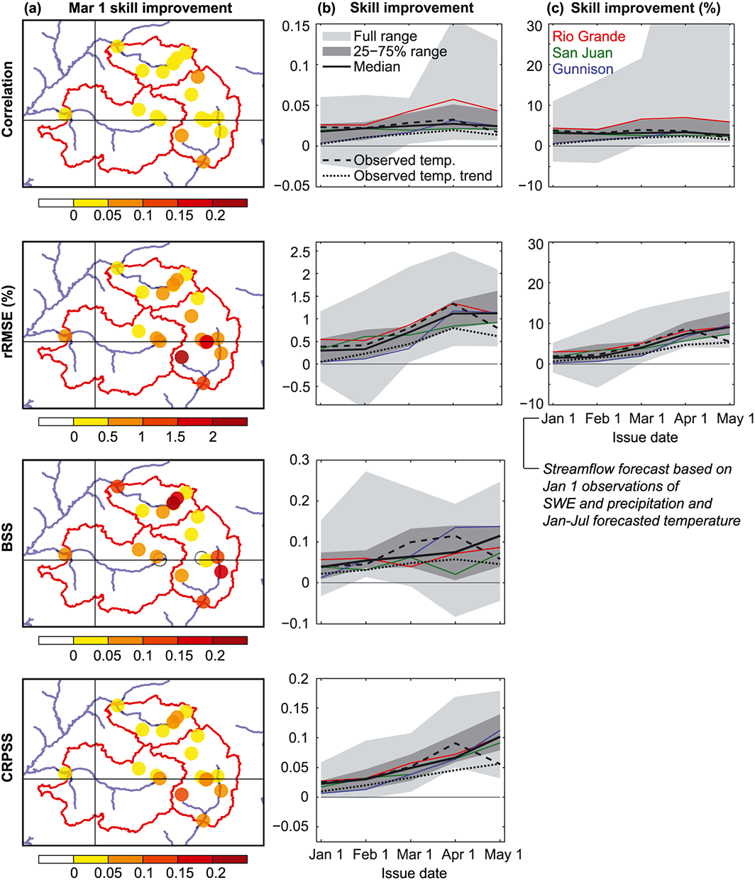 [(a) Absolute skill improvement of the temperature-aided forecast relative to the baseline forecast at individual gages for issue date 1 March as an illustrative example. (b) Absolute skill improvement for all gages as a function of issue date. (c) Relative skill improvement for all gages as a function of issue date. Solid lines are the median across (black) all gages and (colors) the three basins. Dashed line is the median across all gages when using observed temperature, mimicking the hypothetical case where the future temperature is known at the time of forecast issue, and dotted line is the median when using only the linear trend of observed temperature.]
Fostering these kinds of applications is the overarching goal of the Postdocs Applying Climate Expertise program that supports Lehner's research. PACE is run by the Cooperative Programs for the Advancement of Earth System Science, a community program of the University Corporation for Atmospheric Research.
"This project has enabled stakeholders and scientists to work together directly to tackle a concrete water-related problem arising from the variability and trends we’ve observed in our regional climate," said Llewellyn, a scientist at the Bureau of Reclamation and study co-author.
Edited for WeatherNation by Meteorologist Mace Michaels
[(a) Absolute skill improvement of the temperature-aided forecast relative to the baseline forecast at individual gages for issue date 1 March as an illustrative example. (b) Absolute skill improvement for all gages as a function of issue date. (c) Relative skill improvement for all gages as a function of issue date. Solid lines are the median across (black) all gages and (colors) the three basins. Dashed line is the median across all gages when using observed temperature, mimicking the hypothetical case where the future temperature is known at the time of forecast issue, and dotted line is the median when using only the linear trend of observed temperature.]
Fostering these kinds of applications is the overarching goal of the Postdocs Applying Climate Expertise program that supports Lehner's research. PACE is run by the Cooperative Programs for the Advancement of Earth System Science, a community program of the University Corporation for Atmospheric Research.
"This project has enabled stakeholders and scientists to work together directly to tackle a concrete water-related problem arising from the variability and trends we’ve observed in our regional climate," said Llewellyn, a scientist at the Bureau of Reclamation and study co-author.
Edited for WeatherNation by Meteorologist Mace Michaels
[Colorado River by Flavio Ensiki via CC by 2.0 from Flickr]
Building on this work, scientists at NCAR tested whether incorporating seasonal temperature predictions into statistical streamflow forecasting models could improve their accuracy. The temperature predictions reflect the recent warming trend as well as whether the months after the forecast date are likely to be warmer or colder than this trend. Results of the new study were published in the journal Geophysical Research Letters.
"Adding temperature predictions into streamflow forecasts will not only improve the information that water managers have today, but it also has the potential to mitigate some of the loss of predictability that we now expect in the future, as the climate continues to warm," said NCAR scientist Flavio Lehner, who co-led the study with NCAR scientist Andy Wood.
[NCAR scientist Flavio Lehner in the upper Rio Grande River watershed near Los Alamos, New Mexico. (Photo courtesy Flavio Lehner.)]
COMPARING "HINDCASTS" WITH AND WITHOUT TEMPERATURE PREDICTIONS
To test whether the addition of seasonal temperature predictions could improve streamflow forecasts, the scientists created "hindcasts" for the headwaters of the Colorado and Rio Grande Rivers (both located in Colorado) for the three decades between 1987 and 2016. The team used historical observations of snowpack, precipitation, and streamflow to issue and evaluate a series of forecasts — on Jan. 1, Feb. 1, March 1, April 1, and May 1 — for each year. These hindcasts emulate the current method of issuing streamflow forecasts, including the calendar dates when those forecasts are issued. The scientists also issued a second set of hindcasts, this time with the addition of seasonal temperature predictions for the region. The seasonal predictions were drawn from the North American Multi-Model Ensemble and the European Centre for Medium-Range Weather Forecasts, which together comprise eight state-of-the-art models used for seasonal climate forecasts.
[(a) March–July mean temperature anomalies relative to 1982–2016 from observations, 40 CMIP5 models, and seasonal prediction models (NMME + ECMWF), averaged over the box indicated in Figure 1a. The red line is the mean across NMME-ECMWF models, the gray line is the mean across CMIP5 models, and the black line is observations. Shading indicates the 5–95% range. (b) Correlation between observed and forecasted temperature for different temperature targets and seasonal prediction models for 1982–2016. Forecasts are initialized at the start of each predicted period. All correlations are significant at 95% confidence.]
The team found that incorporating temperature predictions improved the accuracy of seasonal streamflow forecasts at the majority of river gauges across the headwaters of both basins. The amount of improvement varied between about 1 percent and 10 percent, averaged across the basins.
"We think that model-based temperature predictions could be used to improve water supply forecasts in other watersheds that rely on runoff from snowpack — across the western United States and in other parts of the world," Lehner said "But the degree of improvement will certainly depend on the individual area."
SMOOTHING THE PATH TO ADOPTION
To make it as easy as possible for existing operational forecasting centers to begin incorporating the research findings, the scientists chose to modify existing forecasting techniques to include temperature predictions instead of inventing an entirely new forecasting method. "It's a well-known challenge to transition methods from a research experiment to an operational setting," Wood said. "Here we chose a baseline of a current operational water supply forecast technique so that the approach is an extension to the existing practice, and more likely to be supportable."
[(a) Absolute skill improvement of the temperature-aided forecast relative to the baseline forecast at individual gages for issue date 1 March as an illustrative example. (b) Absolute skill improvement for all gages as a function of issue date. (c) Relative skill improvement for all gages as a function of issue date. Solid lines are the median across (black) all gages and (colors) the three basins. Dashed line is the median across all gages when using observed temperature, mimicking the hypothetical case where the future temperature is known at the time of forecast issue, and dotted line is the median when using only the linear trend of observed temperature.]
Fostering these kinds of applications is the overarching goal of the Postdocs Applying Climate Expertise program that supports Lehner's research. PACE is run by the Cooperative Programs for the Advancement of Earth System Science, a community program of the University Corporation for Atmospheric Research.
"This project has enabled stakeholders and scientists to work together directly to tackle a concrete water-related problem arising from the variability and trends we’ve observed in our regional climate," said Llewellyn, a scientist at the Bureau of Reclamation and study co-author.
Edited for WeatherNation by Meteorologist Mace MichaelsAll Weather News
More

Severe Storms Target the Midwest to the Northeast This Week
Extreme heat will be a big story this week ac
27 Jul 2026 1:50 AM


Tropics: Fausto Heads to Hawaii; Genevieve Rapidly Intensifying
Atlantic BasinBertha has dissipated after mov
27 Jul 2026 1:40 AM

Southeast Flood Risk Lingers Near Stalled Front
A stalled boundary over the Southeast will ke
25 Jul 2026 10:55 AM

Another Round of Storms Targets the Northeast
Tuesday brought severe weather again across p
23 Jul 2026 1:15 AM

Another Round of Severe Weather for the Upper Midwest and Great Lakes
The upper-level low train continues to keep t
21 Jul 2026 1:45 AM