VIDEO: Flooding & Landslide Concerns in Greater Seattle Area
Top Stories
2 Feb 2018 9:51 PM
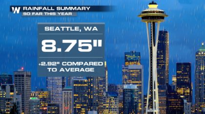
Another round of heavy rainfall is on the way for northwest Washington this weekend. This comes after weeks of wetter-than-average weather so far this year. Here's a short video of the forecast which aired on WeatherNation Friday evening.
https://www.youtube.com/watch?v=Smqi0alayTs&feature=youtu.be
Early February is typically the rainy season for the Pacific Northwest so it is not totally unreasonable to get this wet weather, however it has been rainy since January 1. Take a look:
 We asked the following question via social media Thursday; whether the streak of cloudy/rainy days has gotten anyone 'down.'
https://twitter.com/WeatherNation/status/959218300210196480
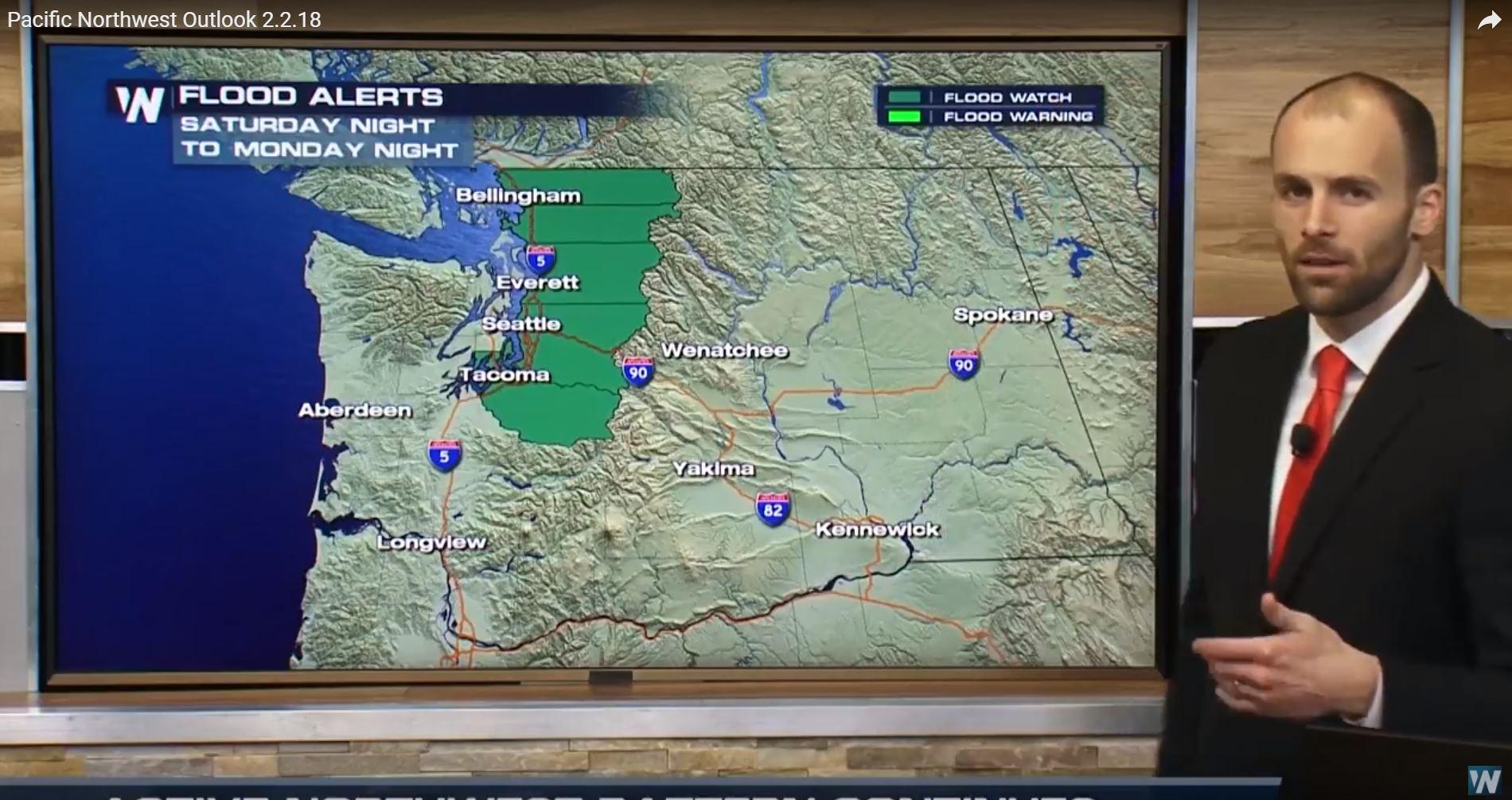
This is the reason a flood watch was posted for northwest Washington. Think of the ground as a sponge. If the sponge is saturated (recent rainfall filling up the soil) then it can't handle as much incoming rain, as compared to a dry sponge that can absorb more rainfall.
We asked the following question via social media Thursday; whether the streak of cloudy/rainy days has gotten anyone 'down.'
https://twitter.com/WeatherNation/status/959218300210196480
This is the reason a flood watch was posted for northwest Washington. Think of the ground as a sponge. If the sponge is saturated (recent rainfall filling up the soil) then it can't handle as much incoming rain, as compared to a dry sponge that can absorb more rainfall.
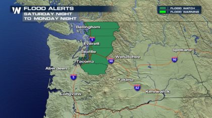 That said, take it slow on the roads and allow extra time for travel. Surfaces will be slick and especially across the mountain passes. Snow levels will range between 5,000 and 7,000 feet above sea level. This moisture will result in feet of snow for the Northwest mountain peaks. The Northwest will dry out late Monday.
https://twitter.com/WeatherNation/status/959295104698613760
For WeatherNation, Meteorologist Steve Glazier
That said, take it slow on the roads and allow extra time for travel. Surfaces will be slick and especially across the mountain passes. Snow levels will range between 5,000 and 7,000 feet above sea level. This moisture will result in feet of snow for the Northwest mountain peaks. The Northwest will dry out late Monday.
https://twitter.com/WeatherNation/status/959295104698613760
For WeatherNation, Meteorologist Steve Glazier
We asked the following question via social media Thursday; whether the streak of cloudy/rainy days has gotten anyone 'down.'
https://twitter.com/WeatherNation/status/959218300210196480
This is the reason a flood watch was posted for northwest Washington. Think of the ground as a sponge. If the sponge is saturated (recent rainfall filling up the soil) then it can't handle as much incoming rain, as compared to a dry sponge that can absorb more rainfall.
That said, take it slow on the roads and allow extra time for travel. Surfaces will be slick and especially across the mountain passes. Snow levels will range between 5,000 and 7,000 feet above sea level. This moisture will result in feet of snow for the Northwest mountain peaks. The Northwest will dry out late Monday.
https://twitter.com/WeatherNation/status/959295104698613760
For WeatherNation, Meteorologist Steve GlazierAll Weather News
More

Flooding, Severe Storms Target the Midwest Again
After an active week of storms across the nor
31 Jul 2026 11:15 PM


After Reaching Category 5, Genevieve Weakens in the Pacific
PacificFausto is now a post-tropical cyclone.
31 Jul 2026 1:30 AM

Flooding Risk Increases as Heavy Rain Targets the Tri-State Area
Tuesday, heavy rainfall moved across the Nort
30 Jul 2026 12:25 AM

Severe Weather: Energy From the Midwest Now in the Southeast
UPPER MIDWEST - Through Monday, dangerous tor
29 Jul 2026 10:30 PM