Wettest Year on Record in Baltimore
Special Stories
16 Nov 2018 9:35 AM
The latest round of wintry weather that rocked the Midwest and Northeast brought plenty of precipitation in the form of rain, freezing rain, and snow. The storm brought 1.33 inches of precipitation to the city of Baltimore on Thursday. Much of that was rain, but some of it was also snow. In fact, Maryland's largest city set a snowfall record for November 15th.
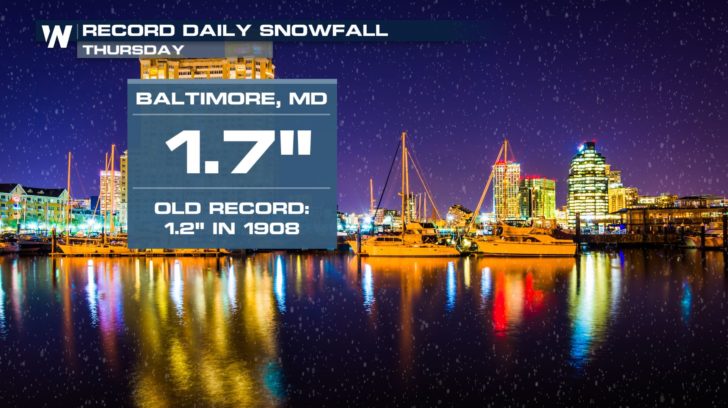 Baltimore's average first snowfall is December 14th. So Thursday's snow was fairly early for the winter season....impressive in its own right. The more impressive record was that Thursday's precipitation moved 2018 to the wettest year on record in Baltimore!
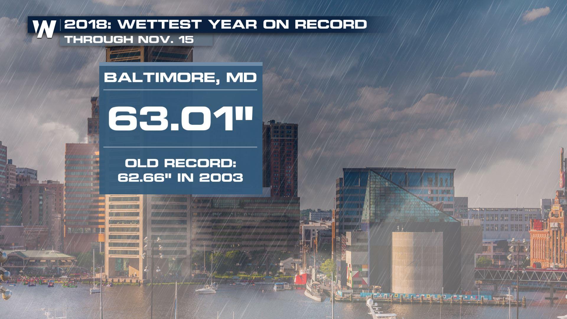
Through November 15th, 63.01 inches of precipitation had been observed at Baltimore's airport. According to the National Weather Service, weather records for the Baltimore area have been kept at Baltimore-Washington International Thurgood Marshall Airport (BWI) since 1950. Precipitation records observed in downtown Baltimore extend the period of record back to 1871. On average, the Charm City should typically receive 40.89 inches of precipitation during a calendar year.
Baltimore's average first snowfall is December 14th. So Thursday's snow was fairly early for the winter season....impressive in its own right. The more impressive record was that Thursday's precipitation moved 2018 to the wettest year on record in Baltimore!
Through November 15th, 63.01 inches of precipitation had been observed at Baltimore's airport. According to the National Weather Service, weather records for the Baltimore area have been kept at Baltimore-Washington International Thurgood Marshall Airport (BWI) since 1950. Precipitation records observed in downtown Baltimore extend the period of record back to 1871. On average, the Charm City should typically receive 40.89 inches of precipitation during a calendar year.
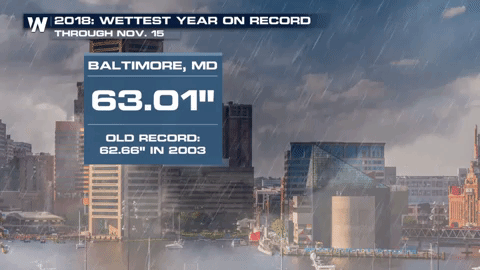 With more than one month left in 2018, the final precipitation total will likely increase for Baltimore. Other cities in the Mid-Atlantic and Ohio Valley regions have also had their wettest year on record in 2018. These include such cities as Washington, DC, and Louisville, Kentucky.
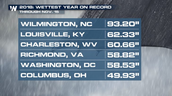 Some of these cities can attribute their high rainfall totals to significant weather events (Hurricane Florence, in Wilmington, North Carolina's case). For others, it has just been an unusually wet year.
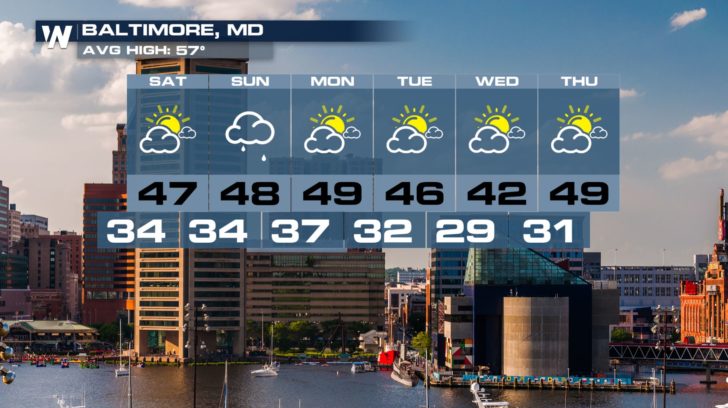
Looking ahead for Baltimore, a few light showers are possible on Sunday. Otherwise, dry conditions are expected through Thanksgiving.
Some of these cities can attribute their high rainfall totals to significant weather events (Hurricane Florence, in Wilmington, North Carolina's case). For others, it has just been an unusually wet year.
Looking ahead for Baltimore, a few light showers are possible on Sunday. Otherwise, dry conditions are expected through Thanksgiving.
 Visit WeatherNation's website for your local forecast.
- Meteorologist Joe Astolfi
Visit WeatherNation's website for your local forecast.
- Meteorologist Joe Astolfi
Baltimore's average first snowfall is December 14th. So Thursday's snow was fairly early for the winter season....impressive in its own right. The more impressive record was that Thursday's precipitation moved 2018 to the wettest year on record in Baltimore!
Through November 15th, 63.01 inches of precipitation had been observed at Baltimore's airport. According to the National Weather Service, weather records for the Baltimore area have been kept at Baltimore-Washington International Thurgood Marshall Airport (BWI) since 1950. Precipitation records observed in downtown Baltimore extend the period of record back to 1871. On average, the Charm City should typically receive 40.89 inches of precipitation during a calendar year.
With more than one month left in 2018, the final precipitation total will likely increase for Baltimore. Other cities in the Mid-Atlantic and Ohio Valley regions have also had their wettest year on record in 2018. These include such cities as Washington, DC, and Louisville, Kentucky.
Some of these cities can attribute their high rainfall totals to significant weather events (Hurricane Florence, in Wilmington, North Carolina's case). For others, it has just been an unusually wet year.
Looking ahead for Baltimore, a few light showers are possible on Sunday. Otherwise, dry conditions are expected through Thanksgiving.
Visit WeatherNation's website for your local forecast.
- Meteorologist Joe AstolfiAll Weather News
More
'MCS' Season Takes Hold with Severe Weather & Flooding Threats for the Plains & Midwest
As Summer settles in across the Central U.S.,
27 Jun 2026 1:30 AM

Weekend System To Shake up Pattern Across the Country
A significant early-summer trough is expected
27 Jun 2026 1:25 AM

Massive Fires Burn in Utah, Extreme Fire Danger Continues Into the Weekend
Photo: Iron Fire getting doused with a retard
27 Jun 2026 12:45 AM

Severe Threat Tracks into the Northeast Friday
Another day, another Illinois tornado. That's
26 Jun 2026 2:25 AM


Front Range Overnight Storms, More Thursday and Friday
FRONT RANGE - Large hail and strong winds pus
25 Jun 2026 2:15 AM

Another Day of Heat For the West Before Changes
This week, an upper-level ridge has taken ove
24 Jun 2026 6:30 PM