When to Expect the Coldest Day of the Year
Special Stories
4 Dec 2018 9:32 AM
[Crossing a snowy bridge. From pixabay via NOAA]
[NOAA] Many areas of the country this week will feel the coldest temperatures that have been felt since last winter. To give you a better idea of the coldest time of year for your area, NOAA has created “Coldest Day of the Year” maps across the nation. The maps are derived from the 1981–2010 U.S. Climate Normals—NCEI’s 30-year averages of climatological variables including the average low temperature for every day. From these values, scientists can identify which day of the year, on average, has the lowest minimum temperature, referred to here as the “coldest day.”
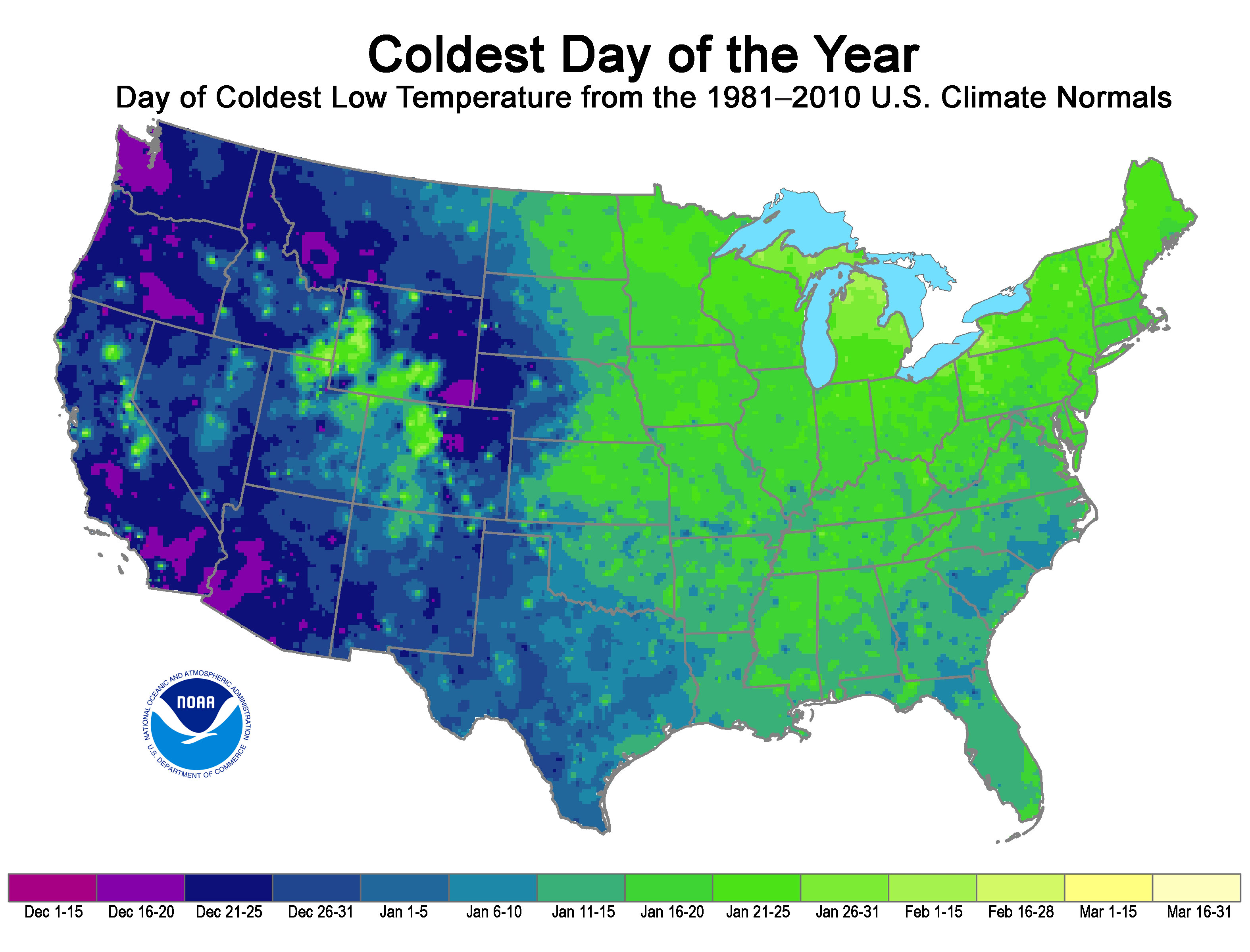 The map reveals several interesting regional differences across the country. Most prominently, the western half of the contiguous United States typically reaches its climatological coldest day in December, whereas most eastern stations reach their minimum in January. In addition, areas with higher snowfall Normals, such as the Northeast and high-altitude regions in the West, tend to reach their climatological coldest day much later, which is likely because of the increased reflection of solar radiation at Earth’s surface due to the presence of snow cover.
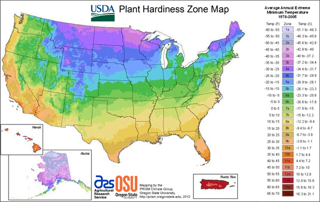 [Average annual extreme minimum temperatures. 1976-2005]
Edited for WeatherNation by Meteorologist Mace Michaels
[Average annual extreme minimum temperatures. 1976-2005]
Edited for WeatherNation by Meteorologist Mace Michaels
The map reveals several interesting regional differences across the country. Most prominently, the western half of the contiguous United States typically reaches its climatological coldest day in December, whereas most eastern stations reach their minimum in January. In addition, areas with higher snowfall Normals, such as the Northeast and high-altitude regions in the West, tend to reach their climatological coldest day much later, which is likely because of the increased reflection of solar radiation at Earth’s surface due to the presence of snow cover.
Temperature Normals are important indicators used in forecasting and monitoring by many U.S. economic sectors. Knowing the probability of low temperatures can help energy companies prepare for rising heating demand. They are also useful planning tools for the healthcare, construction, and tourism industries. You may want to check the Normals before planning your next event or vacation.
[Average annual extreme minimum temperatures. 1976-2005]
Edited for WeatherNation by Meteorologist Mace MichaelsAll Weather News
More

Tropics: Fausto Heads towards Hawaii; Genevieve Cat 4 Hurricane
PacificTropical Storm Fausto continues to tra
28 Jul 2026 10:30 AM

Severe Storms Target the Midwest to the Northeast
UPPER MIDWEST - Through Monday, dangerous tor
28 Jul 2026 10:25 AM

Southeast Flood Risk Lingers Near Stalled Front
A stalled boundary over the Southeast will ke
25 Jul 2026 10:55 AM

Another Round of Storms Targets the Northeast
Tuesday brought severe weather again across p
23 Jul 2026 1:15 AM

Another Round of Severe Weather for the Upper Midwest and Great Lakes
The upper-level low train continues to keep t
21 Jul 2026 1:45 AM

Air Quality Improvements in the Forecast
Wildfires burning in Northwestern Ontario, Ca
20 Jul 2026 7:20 PM