Wind Chill of -40° Possible Saturday Morning
Special Stories
28 Dec 2018 9:22 PM
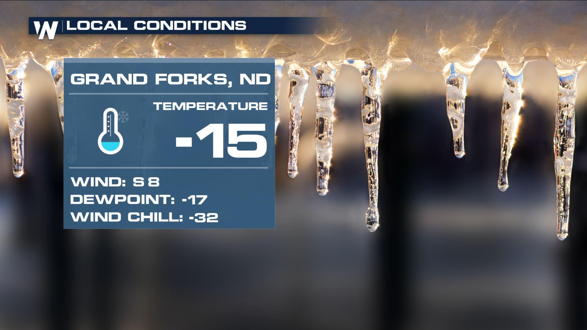
Layers, layers, layers! A Wind Chill Advisory has been issued for parts of the High Plains Saturday morning, December 29th for a feels-like temperature that may sink as low as 40 degrees *below* zero!
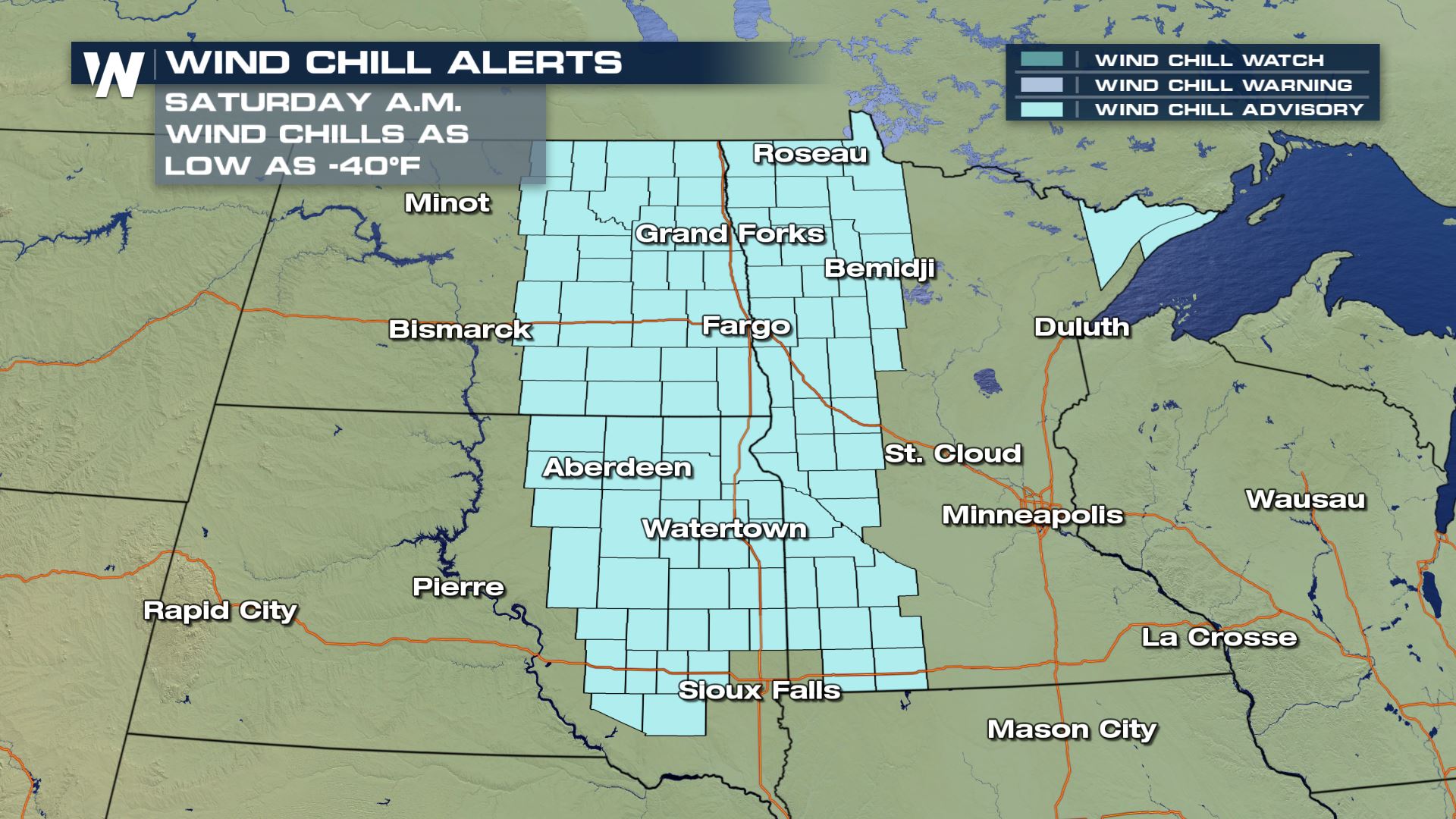 A Wind Chill Advisory is in effect for parts of the High Plains Saturday morning, December 29.
The wind chill is a factor of the temperature and wind. When combined, this is what the air really feels like to the bare skin. When the wind chill approaches -40 degrees, skin damage or frostbite can occur in as little as 15 minutes to unprotected skin!
A Wind Chill Advisory is in effect for parts of the High Plains Saturday morning, December 29.
The wind chill is a factor of the temperature and wind. When combined, this is what the air really feels like to the bare skin. When the wind chill approaches -40 degrees, skin damage or frostbite can occur in as little as 15 minutes to unprotected skin!
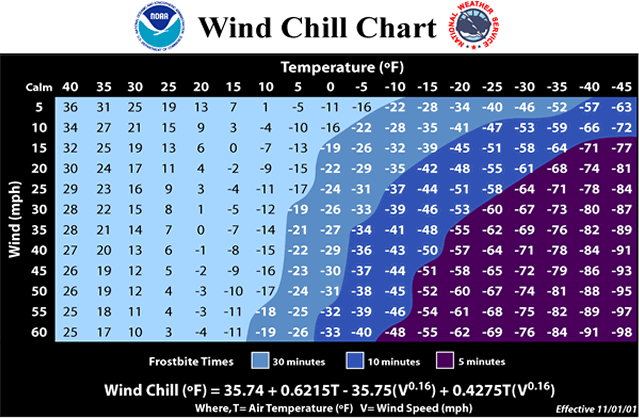 The wind chill chart comparing temperature, wind speed, and the time it may take to develop frostbite. Courtesy NOAA
This area just had several inches of snow Thursday and Friday. That snow will stick around, plus make for some icy spots on Saturday morning.
The wind chill chart comparing temperature, wind speed, and the time it may take to develop frostbite. Courtesy NOAA
This area just had several inches of snow Thursday and Friday. That snow will stick around, plus make for some icy spots on Saturday morning.
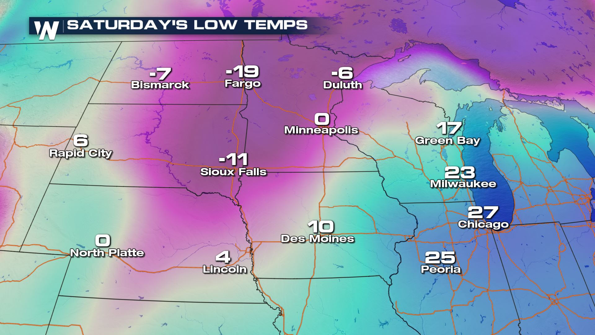 Low temperature forecast Saturday morning, December 29
The actual air temperature will sink into the teens below zero Saturday morning. This image does not include the light, 5-10 mph wind that will make it feel in the twenties or thirties below zero! These low temperatures may seem pretty cold, but this area can get *quite* cold in late December! Take a look:
Low temperature forecast Saturday morning, December 29
The actual air temperature will sink into the teens below zero Saturday morning. This image does not include the light, 5-10 mph wind that will make it feel in the twenties or thirties below zero! These low temperatures may seem pretty cold, but this area can get *quite* cold in late December! Take a look:
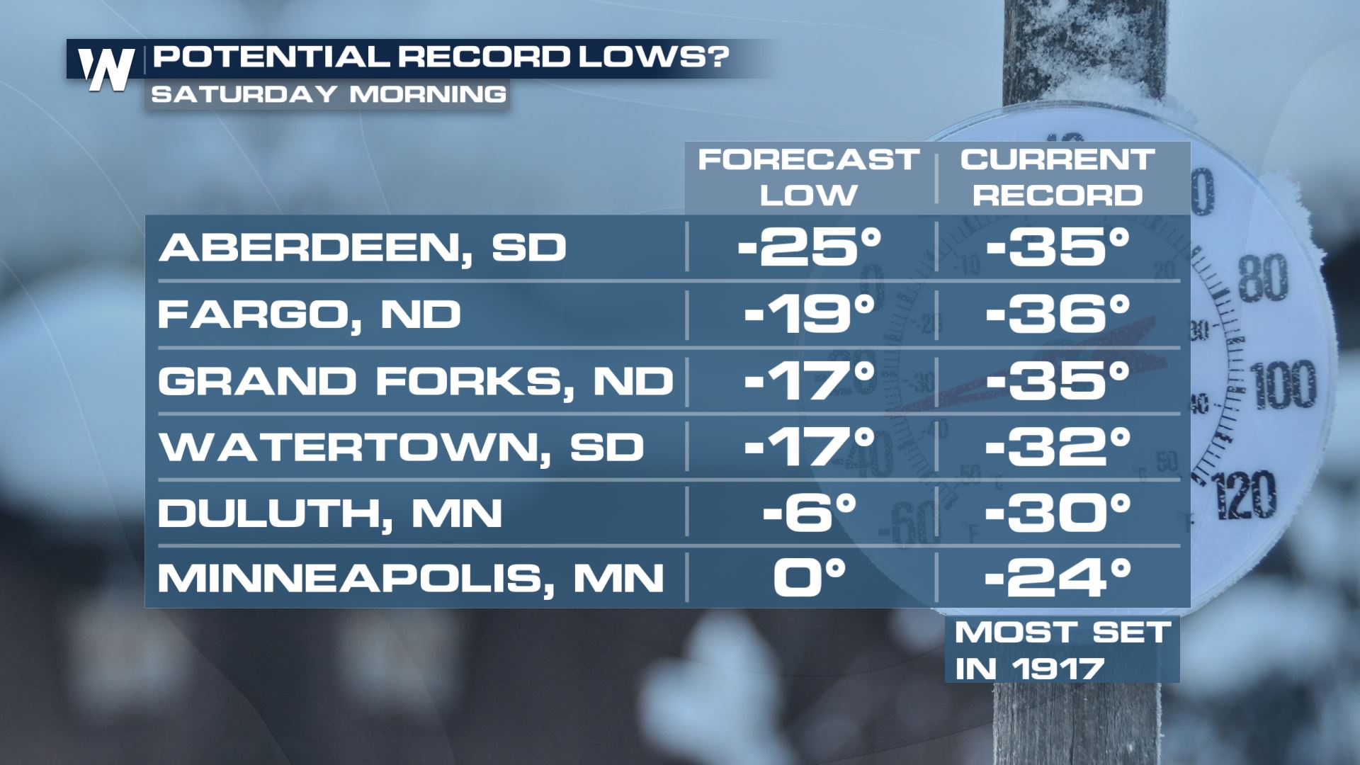 The low temperature forecast Saturday morning (left) compared to the record low temperature (right)
The record low temperatures for Saturday, December 29 are as low as -35°! Thus, it doesn't appear it will be record-breaking cold.
The low temperature forecast Saturday morning (left) compared to the record low temperature (right)
The record low temperatures for Saturday, December 29 are as low as -35°! Thus, it doesn't appear it will be record-breaking cold.
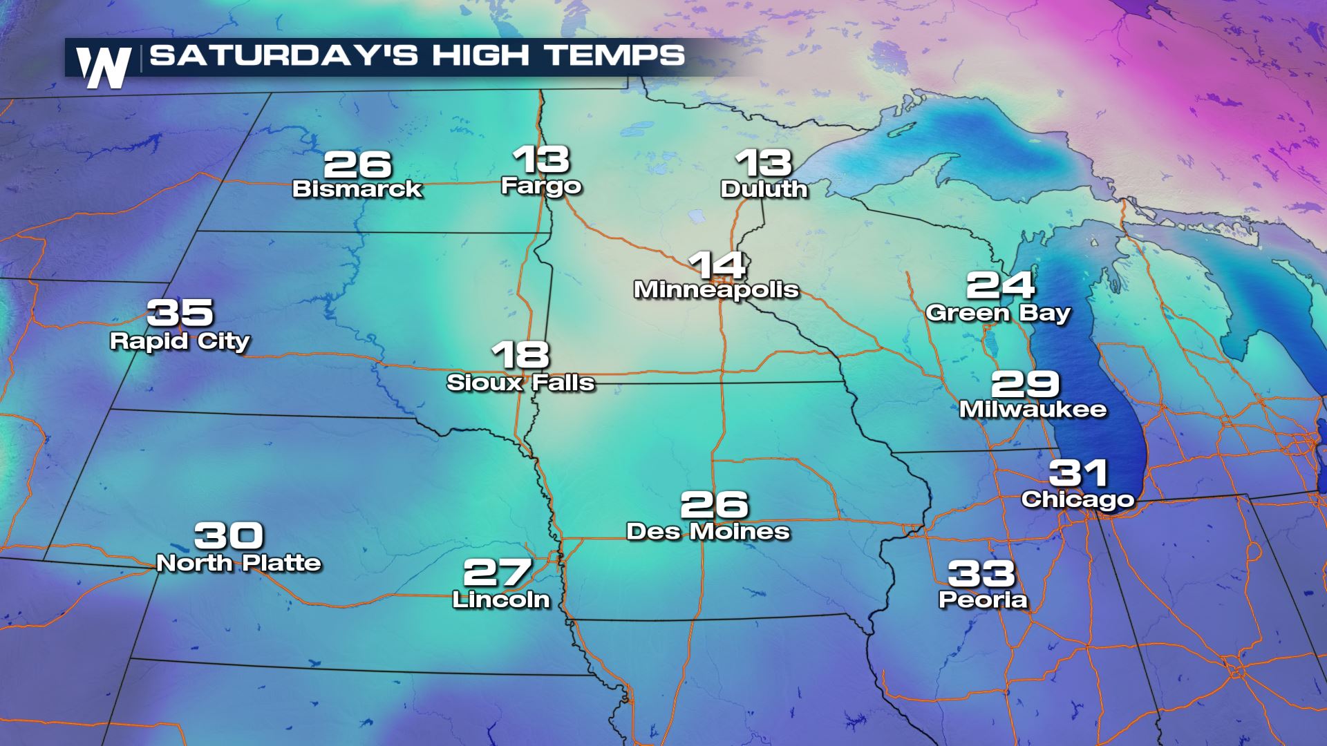 High temperature forecast on Saturday, December 29
Temperatures will rebound, kind of. After starting -10 to -20° the high temperature Saturday afternoon will reach to positive 10 to 20°. After this, the temperature will be *much* warmer on Sunday morning. Expect low temperatures Sunday morning around 15 to 25 degrees *above* zero. In these cold conditions, stay covered and limit the time outdoors with bare skin.
For WeatherNation, Meteorologist Steve Glazier
High temperature forecast on Saturday, December 29
Temperatures will rebound, kind of. After starting -10 to -20° the high temperature Saturday afternoon will reach to positive 10 to 20°. After this, the temperature will be *much* warmer on Sunday morning. Expect low temperatures Sunday morning around 15 to 25 degrees *above* zero. In these cold conditions, stay covered and limit the time outdoors with bare skin.
For WeatherNation, Meteorologist Steve Glazier
A Wind Chill Advisory is in effect for parts of the High Plains Saturday morning, December 29.
The wind chill is a factor of the temperature and wind. When combined, this is what the air really feels like to the bare skin. When the wind chill approaches -40 degrees, skin damage or frostbite can occur in as little as 15 minutes to unprotected skin!
The wind chill chart comparing temperature, wind speed, and the time it may take to develop frostbite. Courtesy NOAA
This area just had several inches of snow Thursday and Friday. That snow will stick around, plus make for some icy spots on Saturday morning.
Low temperature forecast Saturday morning, December 29
The actual air temperature will sink into the teens below zero Saturday morning. This image does not include the light, 5-10 mph wind that will make it feel in the twenties or thirties below zero! These low temperatures may seem pretty cold, but this area can get *quite* cold in late December! Take a look:
The low temperature forecast Saturday morning (left) compared to the record low temperature (right)
The record low temperatures for Saturday, December 29 are as low as -35°! Thus, it doesn't appear it will be record-breaking cold.
High temperature forecast on Saturday, December 29
Temperatures will rebound, kind of. After starting -10 to -20° the high temperature Saturday afternoon will reach to positive 10 to 20°. After this, the temperature will be *much* warmer on Sunday morning. Expect low temperatures Sunday morning around 15 to 25 degrees *above* zero. In these cold conditions, stay covered and limit the time outdoors with bare skin.
For WeatherNation, Meteorologist Steve GlazierAll Weather News
More
East Gears Up for Stormy, Wet Weekend
A low pressure system crashing through the Mi
1 Aug 2026 11:35 PM


Flooding, Severe Storms Target the Midwest Again
After an active week of storms across the nor
1 Aug 2026 1:40 AM

After Reaching Category 5, Genevieve Weakens in the Pacific
PacificFausto is now a post-tropical cyclone.
31 Jul 2026 1:30 AM

Flooding Risk Increases as Heavy Rain Targets the Tri-State Area
Tuesday, heavy rainfall moved across the Nort
30 Jul 2026 12:25 AM

Severe Weather: Energy From the Midwest Now in the Southeast
UPPER MIDWEST - Through Monday, dangerous tor
29 Jul 2026 10:30 PM