With Hazy Skies, Eyes Turn to NOAA Smoke Model
Special Stories
15 Sep 2020 1:04 AM
[Written by NOAA] With smoke from western wildfires spreading from coast to coast this week, people will be looking to a NOAA smoke model for guidance on everything from how it might impact their area, to the weather, to scheduling school recesses.
The High Resolution Rapid Refresh-Smoke model may still be experimental, but many depend on it already, said Michael Staudenmaier, a science and technology division leader with the NOAA’s National Weather Service Western Regional Office in Utah. “When it’s not running during fire season, you hear about it pretty quickly,” he said.
https://youtu.be/xQftyQjMeZw
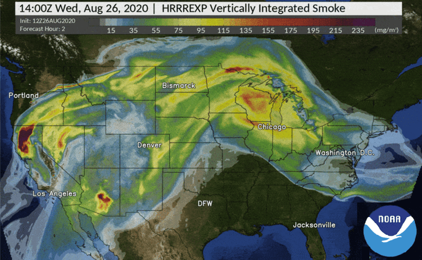
HRRR-Smoke, as it’s known, is the first numerical weather prediction model in the U.S. that forecasts smoke’s impact on a number of weather variables. Based on satellite observations of fire location and intensity, HRRR-Smoke predicts the movement of smoke in three dimensions across the country over 48 hours, simulating how the weather will impact smoke movement and how smoke will affect visibility, temperature and wind.
“Smoke affects the weather in nonlinear kinds of ways,” Staudenmaier said. “In the old days, a forecaster would have looked at a nearby fire and made a prediction that smoke would make it, say, 2 degrees cooler during the day, and keep it 2 degrees warmer overnight. Now, the model puts those variables right into the prediction - how much sunlight the smoke will block, how much heat the smoke will trap, so there’s no more guessing.”
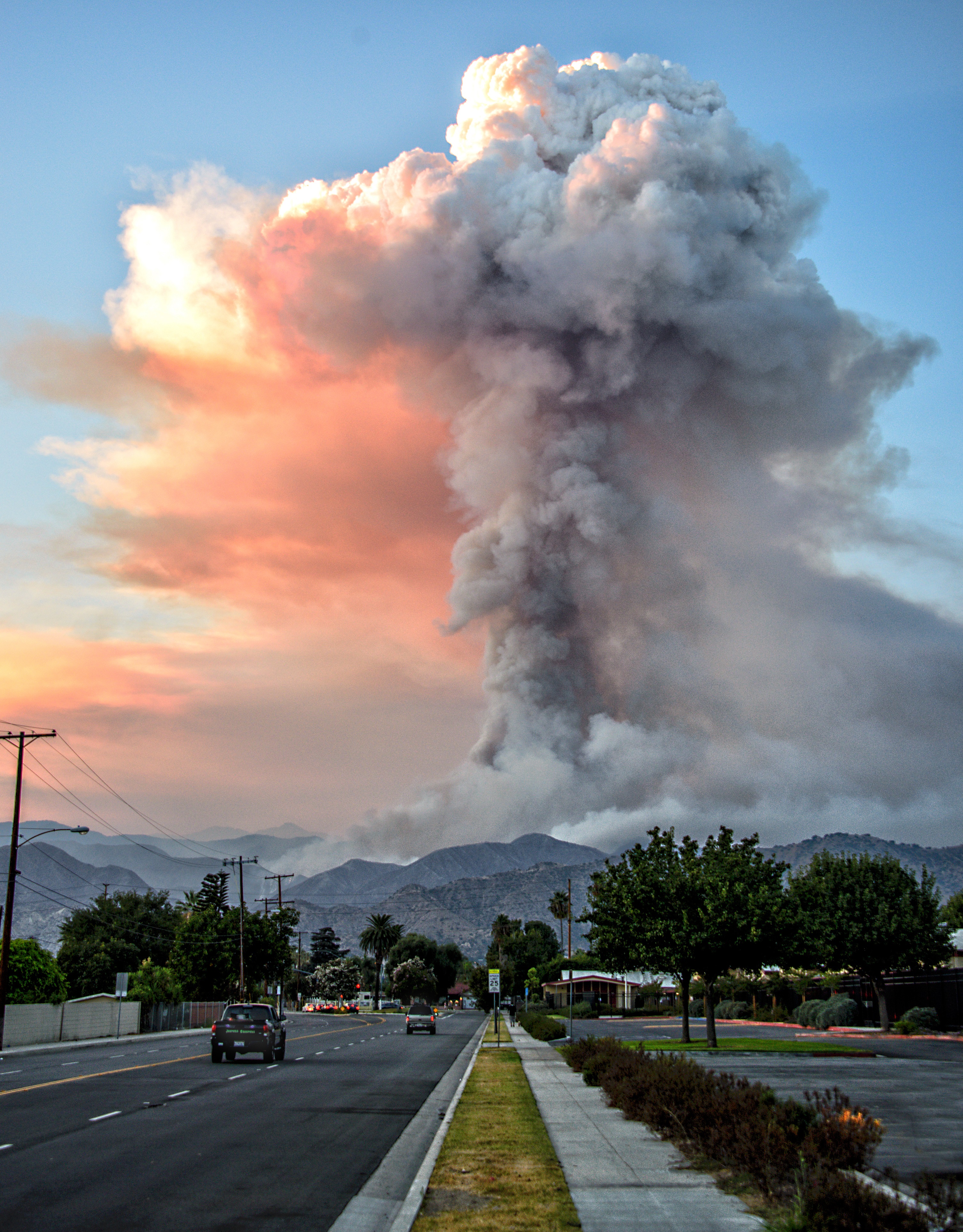 [A tower of smoke rising from the Azusa, California, "Ranch2" wildfire during 100-degree heat, on August 15, 2020. Fire-generated "pyrocumulus" clouds carry smoke high into the atmosphere, where it can travel thousands of miles from its source. Credit: Russ Allison Loar/Flickr Creative Commons]
One of several experimental components of the High Resolution Rapid Refresh weather model developed by NOAA’s Global Systems Laboratory in Boulder, Colorado, HRRR-Smoke is scheduled to be transitioned into the National Weather Service’s suite of operational forecast models later this year. “We do research and development to make forecasts better,” said Jennifer Mahoney, director of the Global Systems Laboratory. “HRRR-Smoke is a great example of that.”
HRRR-Smoke is particularly valuable for notifying those downwind of a fire about what’s headed their way. Wildfire managers may move or redeploy crews based on where heavy smoke will be. Community leaders want to know how much smoke will affect their residents. Public health managers will want to know of potential health impacts on their community. “I’ve heard that schools have canceled recess based on its forecasts, and that National Park Service employees consult it when they get questions about why it’s so hazy across the Grand Canyon,” Staudenmaier said.
[A tower of smoke rising from the Azusa, California, "Ranch2" wildfire during 100-degree heat, on August 15, 2020. Fire-generated "pyrocumulus" clouds carry smoke high into the atmosphere, where it can travel thousands of miles from its source. Credit: Russ Allison Loar/Flickr Creative Commons]
One of several experimental components of the High Resolution Rapid Refresh weather model developed by NOAA’s Global Systems Laboratory in Boulder, Colorado, HRRR-Smoke is scheduled to be transitioned into the National Weather Service’s suite of operational forecast models later this year. “We do research and development to make forecasts better,” said Jennifer Mahoney, director of the Global Systems Laboratory. “HRRR-Smoke is a great example of that.”
HRRR-Smoke is particularly valuable for notifying those downwind of a fire about what’s headed their way. Wildfire managers may move or redeploy crews based on where heavy smoke will be. Community leaders want to know how much smoke will affect their residents. Public health managers will want to know of potential health impacts on their community. “I’ve heard that schools have canceled recess based on its forecasts, and that National Park Service employees consult it when they get questions about why it’s so hazy across the Grand Canyon,” Staudenmaier said.
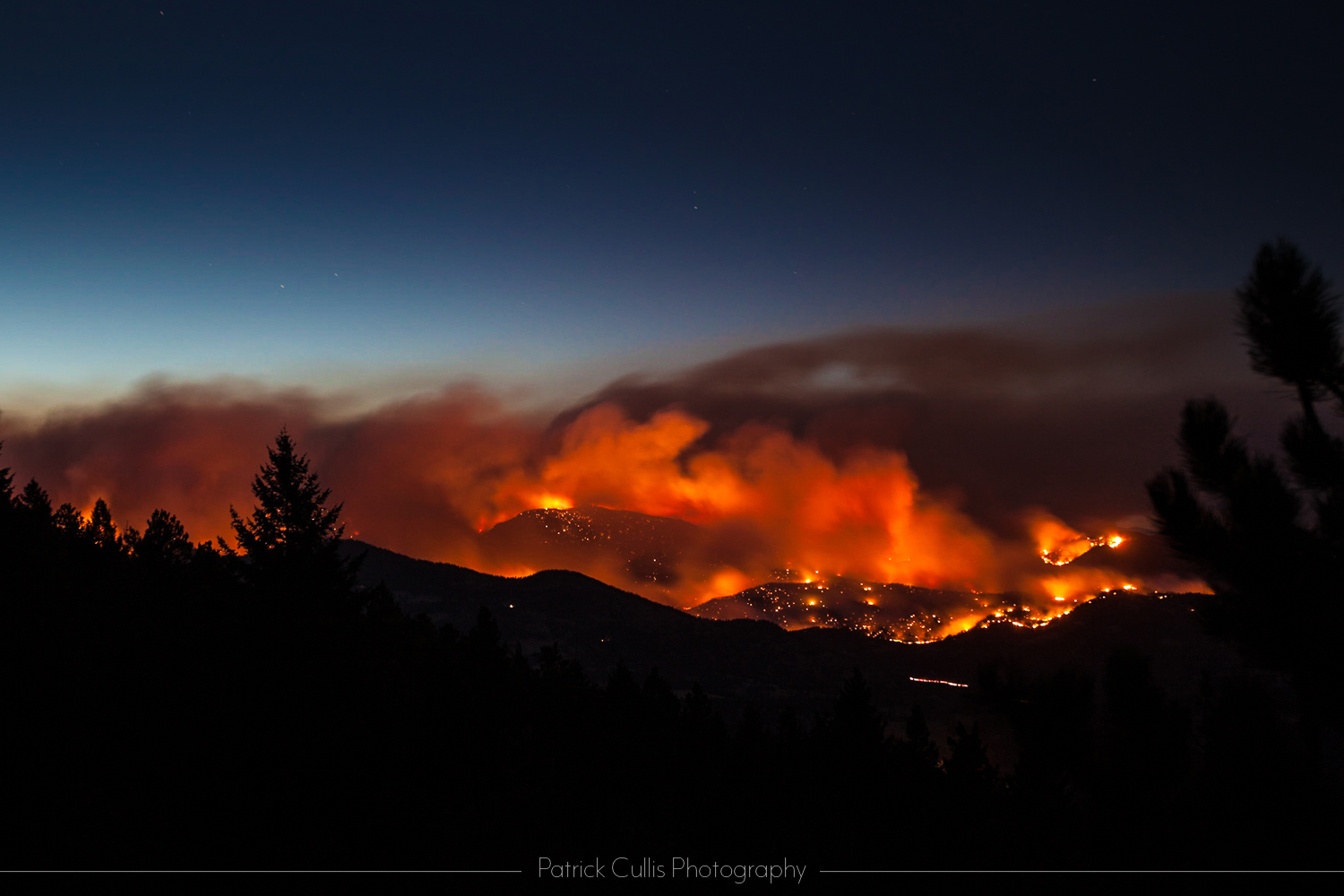 [NOAA's HRRR-Smoke model can help warn fire managers and local communities where heavy smoke will collect when a fire "lays down" overnight, as the Four Mile Fire did in Boulder Colorado in 2010. Credit: Patrick Cullis/CIRES]
 Information gleaned from HRRR-Smoke by Gilman and colleagues will help NOAA scientists build the next generation of air quality models. “That’s the goal, to not only predict where the smoke is going, but with it all the ozone and other pollutants in smoke that affect air quality,” she said. “This model helps us understand the stuff we’re measuring, and that knowledge will ultimately get put into the next model. It’s like a big circle.”
[A tower of smoke rising from the Azusa, California, "Ranch2" wildfire during 100-degree heat, on August 15, 2020. Fire-generated "pyrocumulus" clouds carry smoke high into the atmosphere, where it can travel thousands of miles from its source. Credit: Russ Allison Loar/Flickr Creative Commons]
One of several experimental components of the High Resolution Rapid Refresh weather model developed by NOAA’s Global Systems Laboratory in Boulder, Colorado, HRRR-Smoke is scheduled to be transitioned into the National Weather Service’s suite of operational forecast models later this year. “We do research and development to make forecasts better,” said Jennifer Mahoney, director of the Global Systems Laboratory. “HRRR-Smoke is a great example of that.”
HRRR-Smoke is particularly valuable for notifying those downwind of a fire about what’s headed their way. Wildfire managers may move or redeploy crews based on where heavy smoke will be. Community leaders want to know how much smoke will affect their residents. Public health managers will want to know of potential health impacts on their community. “I’ve heard that schools have canceled recess based on its forecasts, and that National Park Service employees consult it when they get questions about why it’s so hazy across the Grand Canyon,” Staudenmaier said.
[NOAA's HRRR-Smoke model can help warn fire managers and local communities where heavy smoke will collect when a fire "lays down" overnight, as the Four Mile Fire did in Boulder Colorado in 2010. Credit: Patrick Cullis/CIRES]
A WEATHER MODEL THAT DOES CHEMISTRY
The model also continues to be used as a research tool. “I’ve been checking it every day,” said Jessica Gilman, an atmospheric chemist with the Chemical Sciences Laboratory who is studying changes in Boulder pollution levels during the coronavirus pandemic. “Smoke is interesting, and the HRRR gives you much more detail than air quality websites, like how concentrated is it going to be, and where did it come from?” she said. Gilman and her fellow scientists also use the forecasts to schedule maintenance on their highly sensitive instruments, work best done in cleaner air.
Information gleaned from HRRR-Smoke by Gilman and colleagues will help NOAA scientists build the next generation of air quality models. “That’s the goal, to not only predict where the smoke is going, but with it all the ozone and other pollutants in smoke that affect air quality,” she said. “This model helps us understand the stuff we’re measuring, and that knowledge will ultimately get put into the next model. It’s like a big circle.”
To see the latest HRRR-Smoke model visualization, go to: https://hwp-viz.gsd.esrl.noaa.gov/smoke/index.html
All Weather News
More
Severe Storms Target the Midwest to the Northeast
UPPER MIDWEST - Dangerous tornadoes have alre
27 Jul 2026 8:45 PM


Tropics: Fausto Heads towards Hawaii; Genevieve Cat 4 Hurricane
Atlantic BasinBertha has dissipated after mov
27 Jul 2026 3:00 PM

Southeast Flood Risk Lingers Near Stalled Front
A stalled boundary over the Southeast will ke
25 Jul 2026 10:55 AM

Another Round of Storms Targets the Northeast
Tuesday brought severe weather again across p
23 Jul 2026 1:15 AM

Another Round of Severe Weather for the Upper Midwest and Great Lakes
The upper-level low train continues to keep t
21 Jul 2026 1:45 AM