60th Anniversary of the Launch of First NOAA/NASA Satellite
Special Stories
31 Jan 2018 5:03 PM
[Explorer 1 satellite. From NASA]
From NOAA
Today, it’s easy to take for granted our increasingly accurate weather forecasts or the stunning, high-definition Earth-satellite imagery we can view on our home computers (or even cell phones) at the tap of a button. These scientific and technological advancements can be traced back to NASA’s pioneering efforts, when America’s very first satellite, Explorer 1, was launched into space six decades ago. Known as Explorer 1, it was America’s first successful satellite launch, ushering in a new era of space exploration and scientific discovery.
https://www.youtube.com/watch?v=0xo_JAd7mec&feature=youtu.be
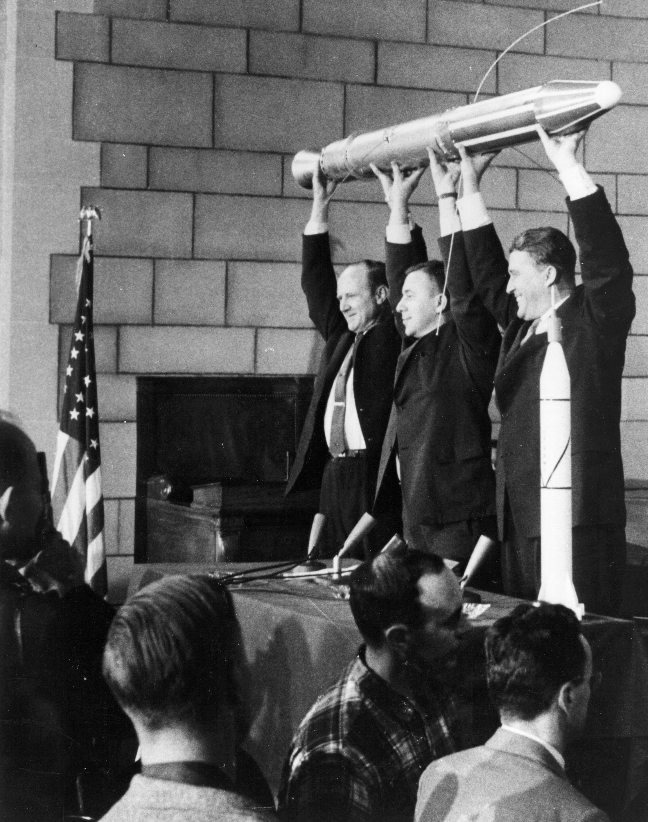 [The three men behind the successful launch of Explorer 1 on January 31, 1958: Dr. William H. Pickering (left), Dr. James A. van Allen (center) and Dr. Wernher von Braun (right). (Credit: NASA)]
To celebrate this milestone, let’s take a look back at NASA’s launch of Explorer 1 and how it paved the way for today’s modern-day weather satellites.
https://www.youtube.com/watch?v=09cRwiWbNrM
[The three men behind the successful launch of Explorer 1 on January 31, 1958: Dr. William H. Pickering (left), Dr. James A. van Allen (center) and Dr. Wernher von Braun (right). (Credit: NASA)]
To celebrate this milestone, let’s take a look back at NASA’s launch of Explorer 1 and how it paved the way for today’s modern-day weather satellites.
https://www.youtube.com/watch?v=09cRwiWbNrM
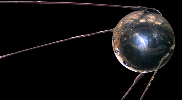
 [Sputnik 1. From NASA]
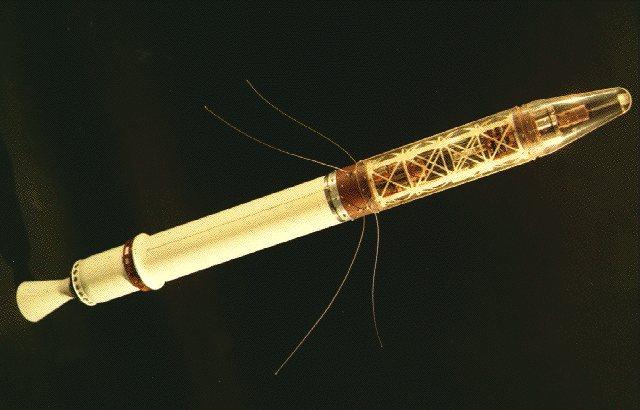
Explorer 1. NASA launched America’s first Earth-orbiting satellite late in the evening on January 31, 1958 (at 10:48 p.m. local time) from Cape Canaveral, Florida. This sleek, pencil-shaped satellite was nearly 7 feet long and a half-foot wide, and weighed just over 30 pounds. The launch occurred barely four months after the Soviet Union successfully sent Sputnik 1, the world’s first manmade satellite, into space.
[Sputnik 1. From NASA]
Explorer 1. NASA launched America’s first Earth-orbiting satellite late in the evening on January 31, 1958 (at 10:48 p.m. local time) from Cape Canaveral, Florida. This sleek, pencil-shaped satellite was nearly 7 feet long and a half-foot wide, and weighed just over 30 pounds. The launch occurred barely four months after the Soviet Union successfully sent Sputnik 1, the world’s first manmade satellite, into space.
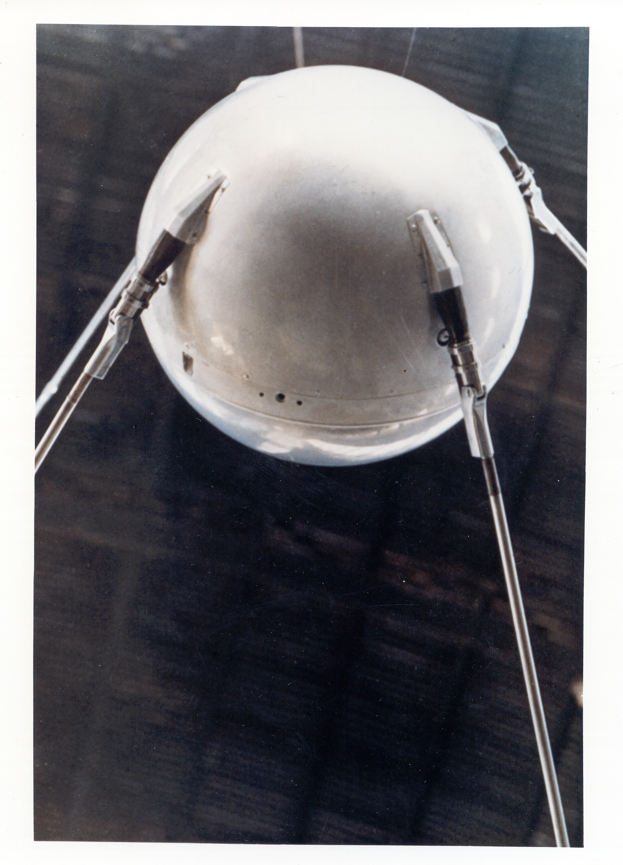
 [A replica of Sputnik 1. Credit: NSSDC/NASA]
Once in orbit, NASA’s Explorer 1 satellite circled the Earth once every 114.8 minutes, or about 12½ times daily - looping around our planet as close as 220 miles or as far as 1,560 miles away. Explorer 1 became famous for discovering Earth’s Van Allen Belts, a zone of highly charged electric particles in Earth’s electromagnetic field that shields our planet from the sun’s damaging cosmic rays.
[A replica of Sputnik 1. Credit: NSSDC/NASA]
Once in orbit, NASA’s Explorer 1 satellite circled the Earth once every 114.8 minutes, or about 12½ times daily - looping around our planet as close as 220 miles or as far as 1,560 miles away. Explorer 1 became famous for discovering Earth’s Van Allen Belts, a zone of highly charged electric particles in Earth’s electromagnetic field that shields our planet from the sun’s damaging cosmic rays.
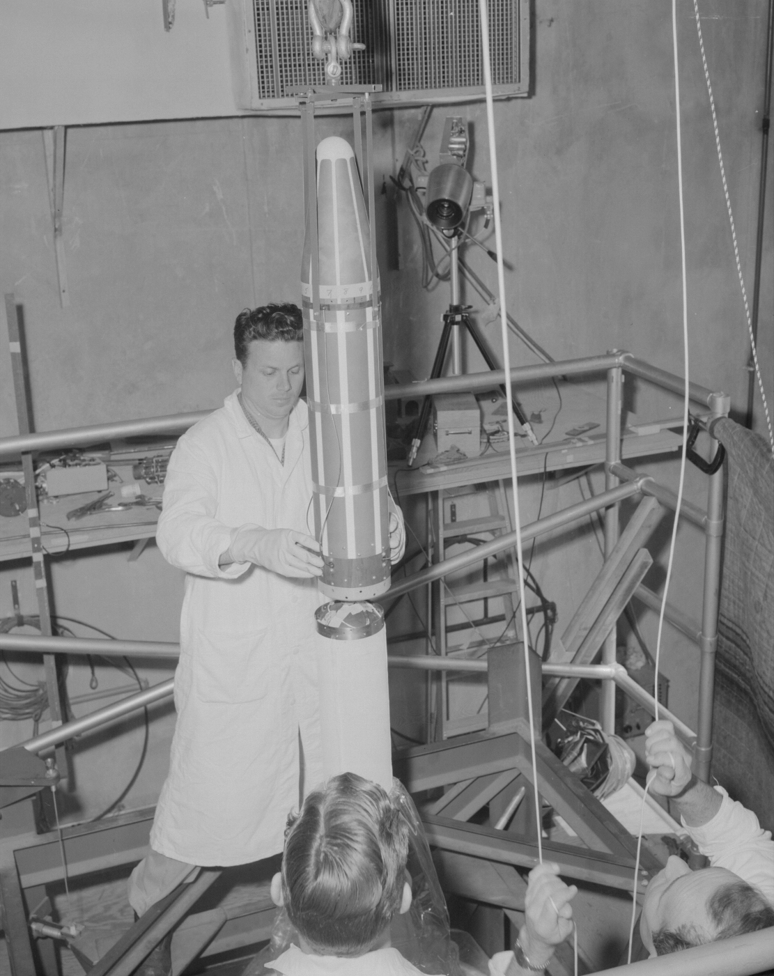 [Technicians lower Explorer 1, the first American satellite, onto the launch vehicle's fourth stage motor. This photo was taken in the gantry at Launch Complex 26 at Cape Canaveral, Florida.. From NASA]
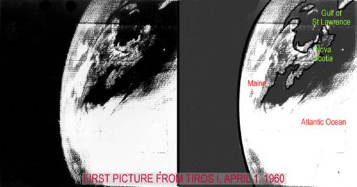
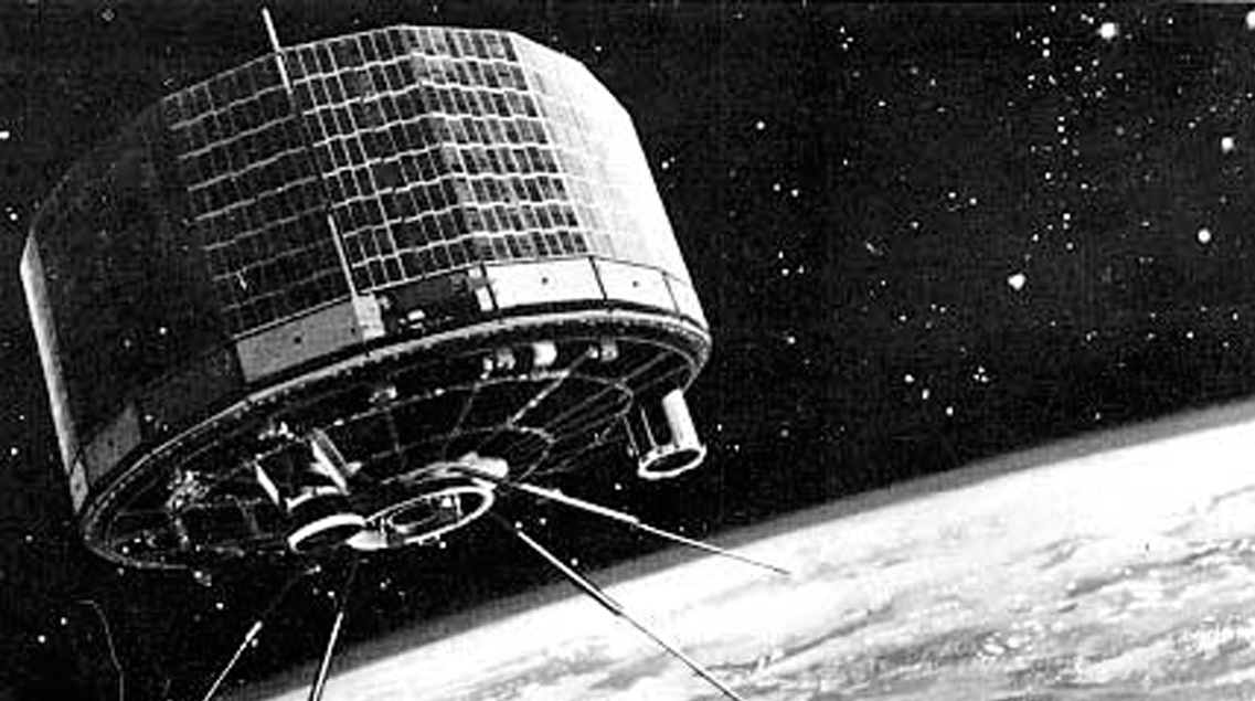 [The TIROS-1 satellite. (NASA)]
Equipped with two TV cameras and two video recorders, the spacecraft orbited 450 miles above Earth, relaying nearly 20,000 images of clouds and storm systems moving across our planet.
[The TIROS-1 satellite. (NASA)]
Equipped with two TV cameras and two video recorders, the spacecraft orbited 450 miles above Earth, relaying nearly 20,000 images of clouds and storm systems moving across our planet.
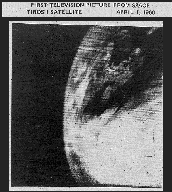 Though TIROS-1 was operational for only 78 days, the images it transmitted underscored the importance of monitoring global weather conditions from space - still a novel concept in the early 1960s. The success of TIROS-1 fueled demand for additional, more technologically advanced weather observation satellites that could gather more data and provide higher-resolution imagery.
 By 1970, atmospheric scientists and engineers at the National Oceanic and Atmospheric Administration celebrated their own milestone: On December 11 that year, NOAA’s first polar-orbiting satellite, NOAA-1, was launched into space. The 674-pound satellite, a joint NOAA/NASA venture, would provide detailed cloud imagery and make significant contributions to understanding Earth’s radiation budget and monitoring space weather.
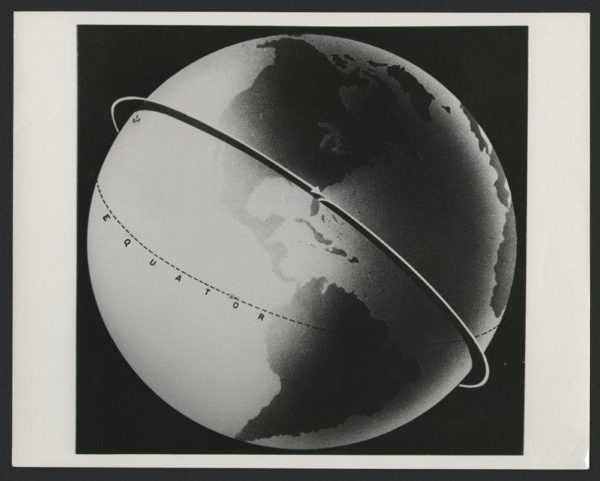 [Illustration of Explorer 1’s approximate path. Credit: U.S. Army, 1958.]
Five years later, on October 16, 1975, NOAA launched GOES-1, the world’s first geostationary operational environmental satellite. From its perch above Earth some 22,000 miles away, GOES-1 became an essential tool used by NOAA’s National Weather Service. The revolutionary satellite gave forecasters a near-real time view of the Earth’s changing atmosphere from a fixed location, providing imagery and data of storms and severe weather events as they unfolded.
[Illustration of Explorer 1’s approximate path. Credit: U.S. Army, 1958.]
Five years later, on October 16, 1975, NOAA launched GOES-1, the world’s first geostationary operational environmental satellite. From its perch above Earth some 22,000 miles away, GOES-1 became an essential tool used by NOAA’s National Weather Service. The revolutionary satellite gave forecasters a near-real time view of the Earth’s changing atmosphere from a fixed location, providing imagery and data of storms and severe weather events as they unfolded.
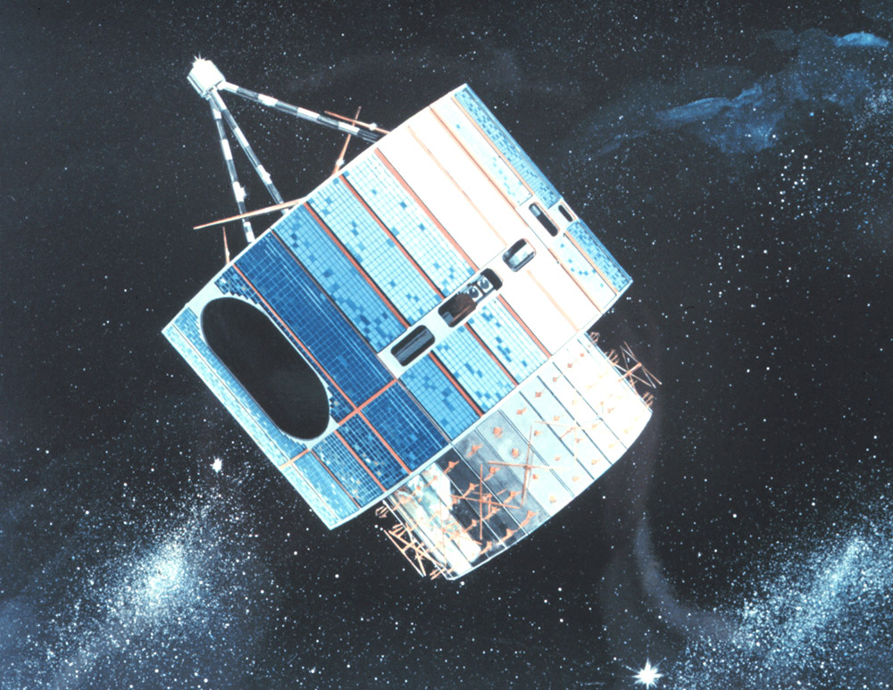 [NOAA’s first geostationary Earth-orbiting satellite, GOES-1.]
Today, NOAA’s advanced constellation of environmental satellites has become an integral part of life-saving weather and climate forecasts in the United States and continues to advance the way we understand and view our dynamic and changing planet from space.
For WeatherNation: Meteorologist Mace Michaels
[NOAA’s first geostationary Earth-orbiting satellite, GOES-1.]
Today, NOAA’s advanced constellation of environmental satellites has become an integral part of life-saving weather and climate forecasts in the United States and continues to advance the way we understand and view our dynamic and changing planet from space.
For WeatherNation: Meteorologist Mace Michaels
[The three men behind the successful launch of Explorer 1 on January 31, 1958: Dr. William H. Pickering (left), Dr. James A. van Allen (center) and Dr. Wernher von Braun (right). (Credit: NASA)]
To celebrate this milestone, let’s take a look back at NASA’s launch of Explorer 1 and how it paved the way for today’s modern-day weather satellites.
https://www.youtube.com/watch?v=09cRwiWbNrM
[Sputnik 1. From NASA]
Explorer 1. NASA launched America’s first Earth-orbiting satellite late in the evening on January 31, 1958 (at 10:48 p.m. local time) from Cape Canaveral, Florida. This sleek, pencil-shaped satellite was nearly 7 feet long and a half-foot wide, and weighed just over 30 pounds. The launch occurred barely four months after the Soviet Union successfully sent Sputnik 1, the world’s first manmade satellite, into space.
[A replica of Sputnik 1. Credit: NSSDC/NASA]
Once in orbit, NASA’s Explorer 1 satellite circled the Earth once every 114.8 minutes, or about 12½ times daily - looping around our planet as close as 220 miles or as far as 1,560 miles away. Explorer 1 became famous for discovering Earth’s Van Allen Belts, a zone of highly charged electric particles in Earth’s electromagnetic field that shields our planet from the sun’s damaging cosmic rays.
[Technicians lower Explorer 1, the first American satellite, onto the launch vehicle's fourth stage motor. This photo was taken in the gantry at Launch Complex 26 at Cape Canaveral, Florida.. From NASA]
The road to weather satellites
The launch of Sputnik and Explorer 1 not only heralded a new Space Age, but also paved the way for America’s weather observation satellite program. Two years after Explorer 1 headed to space, NASA launched the first television infrared observation satellite (TIROS-1, for short) in April of 1960.
[The TIROS-1 satellite. (NASA)]
Equipped with two TV cameras and two video recorders, the spacecraft orbited 450 miles above Earth, relaying nearly 20,000 images of clouds and storm systems moving across our planet.
Though TIROS-1 was operational for only 78 days, the images it transmitted underscored the importance of monitoring global weather conditions from space - still a novel concept in the early 1960s. The success of TIROS-1 fueled demand for additional, more technologically advanced weather observation satellites that could gather more data and provide higher-resolution imagery.
By 1970, atmospheric scientists and engineers at the National Oceanic and Atmospheric Administration celebrated their own milestone: On December 11 that year, NOAA’s first polar-orbiting satellite, NOAA-1, was launched into space. The 674-pound satellite, a joint NOAA/NASA venture, would provide detailed cloud imagery and make significant contributions to understanding Earth’s radiation budget and monitoring space weather.
[Illustration of Explorer 1’s approximate path. Credit: U.S. Army, 1958.]
Five years later, on October 16, 1975, NOAA launched GOES-1, the world’s first geostationary operational environmental satellite. From its perch above Earth some 22,000 miles away, GOES-1 became an essential tool used by NOAA’s National Weather Service. The revolutionary satellite gave forecasters a near-real time view of the Earth’s changing atmosphere from a fixed location, providing imagery and data of storms and severe weather events as they unfolded.
[NOAA’s first geostationary Earth-orbiting satellite, GOES-1.]
Today, NOAA’s advanced constellation of environmental satellites has become an integral part of life-saving weather and climate forecasts in the United States and continues to advance the way we understand and view our dynamic and changing planet from space.
For WeatherNation: Meteorologist Mace MichaelsAll Weather News
More
More Storms for the East Through Monday
The threat for flooding rain continues across
3 Aug 2026 6:00 PM


After Reaching Category 5, Genevieve Weakens in the Pacific
PacificGenevieve formed last Friday south of
3 Aug 2026 12:30 AM

Flooding, Severe Storms Target the Midwest Again
After an active week of storms across the nor
1 Aug 2026 1:40 AM

Flooding Risk Increases as Heavy Rain Targets the Tri-State Area
Tuesday, heavy rainfall moved across the Nort
30 Jul 2026 12:25 AM