A Closer Look at the Southwest's Record Breaking Mid June Heat
Special Stories
30 Jun 2021 2:00 AM
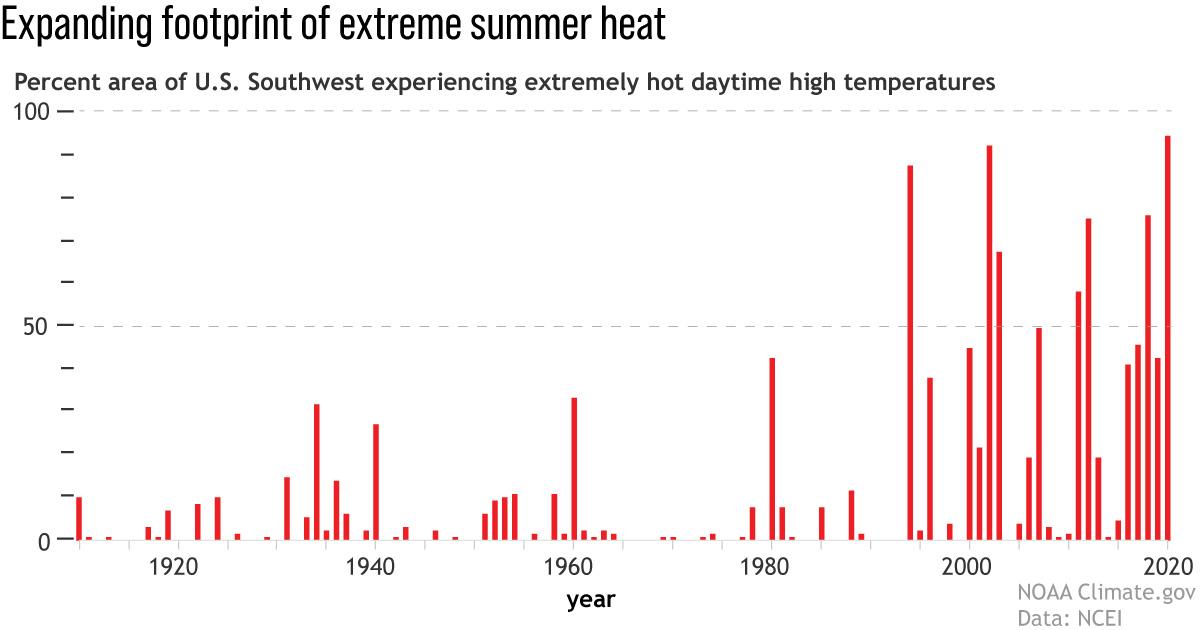
[Red bars show the percent of the U.S. Southwest (Colorado, Utah, Arizona, and New Mexico) having extremely warm days--daytime high temperatures in the top ten percent of the historical record--each summer since 1910. The footprint of extreme heat in the Southwest has exploded in the past 30 years. NOAA Climate graph, based on data from NCEI's Climate Extremes Index.]
An early summer heatwave across the western United States broke all-time records in multiple states, with temperatures above 100 degrees Fahrenheit for days on end in some places. This event marked yet another climate extreme for residents of a region already suffering through a devastating drought and with memories of last year’s horrific wildfire season likely still fresh on people’s minds.
Over a six-day period during the middle of June 2021, a dome of hot air languished over the western United States, causing temperatures to skyrocket. From June 15-20, all-time maximum temperature records fell at locations in seven different states (CA, AZ, NM, UT, CO, WY, MT). In Phoenix, Arizona, the high temperature was over 115 degrees for a record-setting six consecutive days, topping out at 118 degrees on June 17.
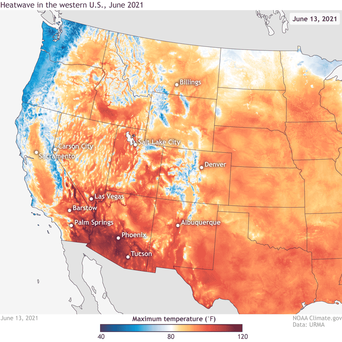 [Daytime high temperatures across the western United States on June 13–19*, 2021, according to data from NOAA's Real-Time Mesoscale Analysis (RTMA). Temperatures reached over 115°F in parts of the Southwest. NOAA Climate animation based on NOAA RTMA data.]
Not to be outdone, Tucson, Arizona, set daily record highs on six consecutive days from June 12-17, with June 15-16 tying for the fourth- and tenth-hottest days on record. The heat lasted from sun-up to sun-down: the temperature at 8 am on June 17 was 98 degrees in Tucson. But if you wanted to experience the hottest temperature anywhere in the country on June 17, then you had to head to Death Valley, where temperatures hit 128 degrees.
The heat extended much farther than the Southwest. Salt Lake City, Utah, tied its all-time record when temperatures hit 107 degrees on June 15, the last day of a three-day streak of high temperatures over 100 degrees. From June 13-19, high temperatures averaged 100 degrees. Billings, Montana, also tied its all-time high of 108 degrees.
[Daytime high temperatures across the western United States on June 13–19*, 2021, according to data from NOAA's Real-Time Mesoscale Analysis (RTMA). Temperatures reached over 115°F in parts of the Southwest. NOAA Climate animation based on NOAA RTMA data.]
Not to be outdone, Tucson, Arizona, set daily record highs on six consecutive days from June 12-17, with June 15-16 tying for the fourth- and tenth-hottest days on record. The heat lasted from sun-up to sun-down: the temperature at 8 am on June 17 was 98 degrees in Tucson. But if you wanted to experience the hottest temperature anywhere in the country on June 17, then you had to head to Death Valley, where temperatures hit 128 degrees.
The heat extended much farther than the Southwest. Salt Lake City, Utah, tied its all-time record when temperatures hit 107 degrees on June 15, the last day of a three-day streak of high temperatures over 100 degrees. From June 13-19, high temperatures averaged 100 degrees. Billings, Montana, also tied its all-time high of 108 degrees.
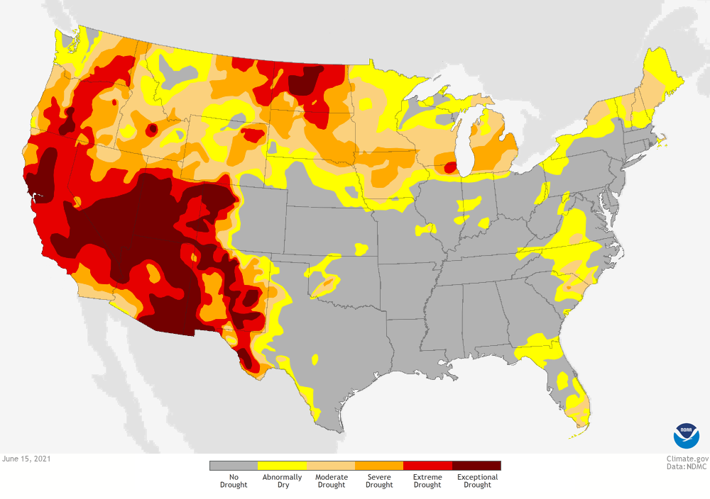 [Drought status across the contiguous United States as of June 15, 2021. A large portion of the West was experiencing drought, and in the Southwest, experts ranked the drought as "exceptional,"—the worst drought category. NOAA Climate image, based on data from U.S. Drought Monitor Project.]
Drought and heat are natural dance partners. Drought conditions are made more likely or more extreme when temperatures soar. And vice versa, hot temperatures can be made even hotter by a drought-stricken landscape. When the ground absorbs incoming sunlight, some of that energy converts soil moisture into water vapor, which carries heat away from the surface. Less moisture in the soil means less solar energy being used to evaporate water. Instead, that energy heats the ground and the air.
Naturally, one consequence of hot temperatures and a dry region is a heightened risk for wildfires. And during the middle of June, that risk turned to reality as wildfires sprung up in California, Arizona, Colorado, Utah and Montana. While the North American summer monsoon is normally expected to tamp down wildfire risk across the Southwest, for the rest of the West, the wildfire season is only just beginning.
Edited for WeatherNation by Mace Michaels
[Drought status across the contiguous United States as of June 15, 2021. A large portion of the West was experiencing drought, and in the Southwest, experts ranked the drought as "exceptional,"—the worst drought category. NOAA Climate image, based on data from U.S. Drought Monitor Project.]
Drought and heat are natural dance partners. Drought conditions are made more likely or more extreme when temperatures soar. And vice versa, hot temperatures can be made even hotter by a drought-stricken landscape. When the ground absorbs incoming sunlight, some of that energy converts soil moisture into water vapor, which carries heat away from the surface. Less moisture in the soil means less solar energy being used to evaporate water. Instead, that energy heats the ground and the air.
Naturally, one consequence of hot temperatures and a dry region is a heightened risk for wildfires. And during the middle of June, that risk turned to reality as wildfires sprung up in California, Arizona, Colorado, Utah and Montana. While the North American summer monsoon is normally expected to tamp down wildfire risk across the Southwest, for the rest of the West, the wildfire season is only just beginning.
Edited for WeatherNation by Mace Michaels
[Daytime high temperatures across the western United States on June 13–19*, 2021, according to data from NOAA's Real-Time Mesoscale Analysis (RTMA). Temperatures reached over 115°F in parts of the Southwest. NOAA Climate animation based on NOAA RTMA data.]
Not to be outdone, Tucson, Arizona, set daily record highs on six consecutive days from June 12-17, with June 15-16 tying for the fourth- and tenth-hottest days on record. The heat lasted from sun-up to sun-down: the temperature at 8 am on June 17 was 98 degrees in Tucson. But if you wanted to experience the hottest temperature anywhere in the country on June 17, then you had to head to Death Valley, where temperatures hit 128 degrees.
The heat extended much farther than the Southwest. Salt Lake City, Utah, tied its all-time record when temperatures hit 107 degrees on June 15, the last day of a three-day streak of high temperatures over 100 degrees. From June 13-19, high temperatures averaged 100 degrees. Billings, Montana, also tied its all-time high of 108 degrees.
Besides the heat, what else was going on?
This extreme heat wave occurred over parts of the country stuck in a deep drought. Over 20% of the country is in the worst two categories of drought (D3-4: Extreme and Exceptional), with the vast majority of that land located in areas that also just saw record-setting temperatures.
[Drought status across the contiguous United States as of June 15, 2021. A large portion of the West was experiencing drought, and in the Southwest, experts ranked the drought as "exceptional,"—the worst drought category. NOAA Climate image, based on data from U.S. Drought Monitor Project.]
Drought and heat are natural dance partners. Drought conditions are made more likely or more extreme when temperatures soar. And vice versa, hot temperatures can be made even hotter by a drought-stricken landscape. When the ground absorbs incoming sunlight, some of that energy converts soil moisture into water vapor, which carries heat away from the surface. Less moisture in the soil means less solar energy being used to evaporate water. Instead, that energy heats the ground and the air.
Naturally, one consequence of hot temperatures and a dry region is a heightened risk for wildfires. And during the middle of June, that risk turned to reality as wildfires sprung up in California, Arizona, Colorado, Utah and Montana. While the North American summer monsoon is normally expected to tamp down wildfire risk across the Southwest, for the rest of the West, the wildfire season is only just beginning.
Edited for WeatherNation by Mace MichaelsAll Weather News
More
Wildfire Outbreak in the Pacific Northwest
SPOKANE, WA - On Saturday, August 1st, the Ol
3 Aug 2026 1:55 AM

More Storms for the East Through Monday
A low-pressure system that moved through the
3 Aug 2026 1:50 AM


After Reaching Category 5, Genevieve Weakens in the Pacific
PacificGenevieve formed last Friday south of
3 Aug 2026 12:30 AM

Flooding, Severe Storms Target the Midwest Again
After an active week of storms across the nor
1 Aug 2026 1:40 AM

Flooding Risk Increases as Heavy Rain Targets the Tri-State Area
Tuesday, heavy rainfall moved across the Nort
30 Jul 2026 12:25 AM

Severe Weather: Energy From the Midwest Now in the Southeast
UPPER MIDWEST - Through Monday, dangerous tor
29 Jul 2026 10:30 PM