A Faster and More Accurate Way to Monitor Drought
Special Stories
13 Mar 2019 3:17 AM
[Duke] More than 2 billion people worldwide are affected by water shortages, wildfires, crop losses, forest diebacks or other environmental or economic woes brought on by drought.
A new monitoring method developed at Duke University allows scientists to identify the onset of drought sooner -- meaning conservation or remediation measures might be put into place sooner to help limit the damage. They published their peer-reviewed findings February 16 in the journal Agricultural and Forest Meteorology.
“By combining surface and air temperature measurements from thousands of weather stations and satellite images, we can monitor current conditions across an entire region in near real time and identify the specific places where drought-induced thermal stress is occurring,” said James S. Clark, Nicholas Professor of Environmental Sciences at Duke’s Nicholas School of the Environment.
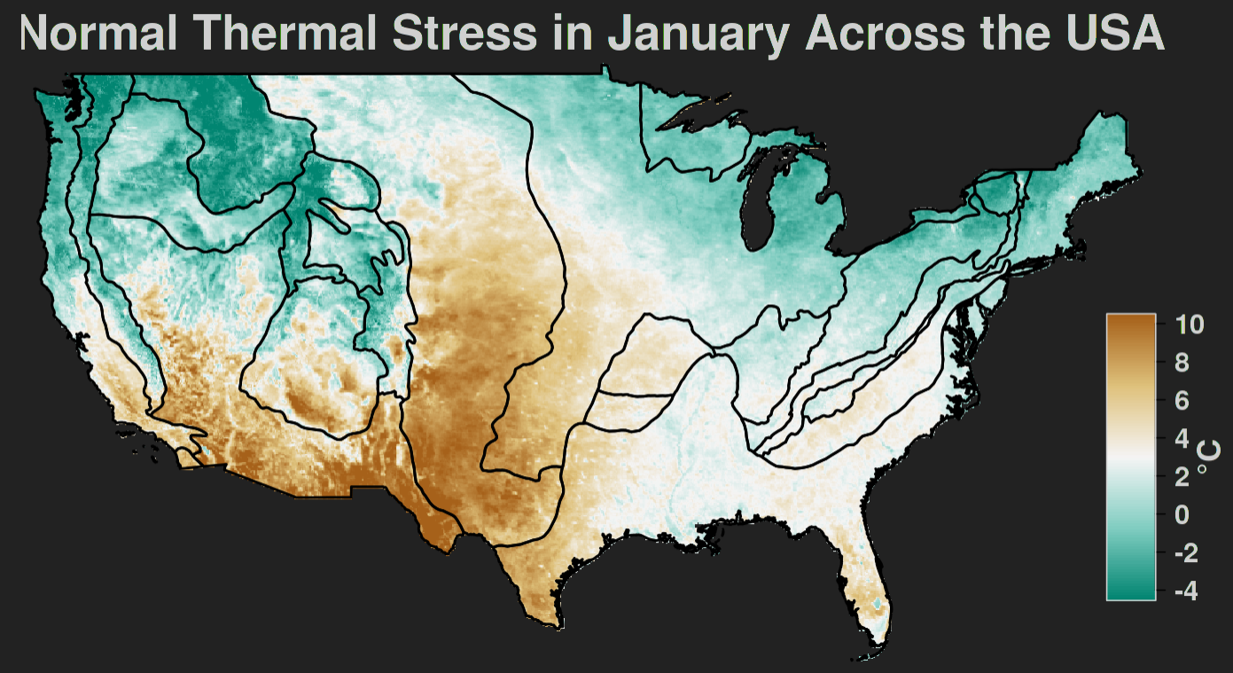
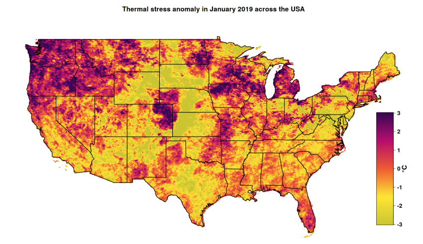 [A new monitoring method created at Duke University identifies the onset of drought faster and more accurately than other methods now in use. Monthly maps are posted on a public website to make the updated data widely available. (Credit: Duke Univ.)]
Clark and his colleagues have created a free public website, called Drought Eye, where they post monthly maps pinpointing locations across the continental United States where drought conditions may be occurring, based on the latest thermal stress data.
The thermal stress they’ve measured is the difference between the air temperature at a site and the surface temperature of the plant canopy there. Ordinarily, these canopies are cooled by water evaporating into the air through small pores, or stomata, in the plants’ leaves. This explains why midday temperatures in a forest in summer are cooler than in a city. During prolonged periods without rain, however, the cooling mechanism breaks down. Ground moisture available to the trees becomes limited. To conserve their water supply, the trees close their stomata, allowing the canopy’s surface to heat up.
“This led us to speculate that the canopy-atmosphere differential could provide a simple but highly accurate indicator of drought-induced water stress on a continental scale during warm and dry seasons, when the threat of wildfires and other impacts is most severe and timely monitoring is essential,” said Bijan Seyednasrollah, a 2017 graduate of the Nicholas School, who led the research as part of his doctoral dissertation.
[A new monitoring method created at Duke University identifies the onset of drought faster and more accurately than other methods now in use. Monthly maps are posted on a public website to make the updated data widely available. (Credit: Duke Univ.)]
Clark and his colleagues have created a free public website, called Drought Eye, where they post monthly maps pinpointing locations across the continental United States where drought conditions may be occurring, based on the latest thermal stress data.
The thermal stress they’ve measured is the difference between the air temperature at a site and the surface temperature of the plant canopy there. Ordinarily, these canopies are cooled by water evaporating into the air through small pores, or stomata, in the plants’ leaves. This explains why midday temperatures in a forest in summer are cooler than in a city. During prolonged periods without rain, however, the cooling mechanism breaks down. Ground moisture available to the trees becomes limited. To conserve their water supply, the trees close their stomata, allowing the canopy’s surface to heat up.
“This led us to speculate that the canopy-atmosphere differential could provide a simple but highly accurate indicator of drought-induced water stress on a continental scale during warm and dry seasons, when the threat of wildfires and other impacts is most severe and timely monitoring is essential,” said Bijan Seyednasrollah, a 2017 graduate of the Nicholas School, who led the research as part of his doctoral dissertation.
 To test the hypothesis, he used measurements of thermal stress from thousands of sites to retroactively “predict” drought conditions across the contiguous U.S. over the past 15 years. He then ran similar tests using other widely employed drought indices to see which of the methods, new or old, produced results that most closely mirrored the historical record.
“Among the drought metrics that we considered, thermal stress had the highest correlation values and most accurately ‘predicted’ the onset of drought in a wide range of atmospheric and climate conditions,” said Seyednasrollah, who is now a postdoctoral environmental scientist at Harvard University and Northern Arizona University.
The new index will enable local authorities to determine the risks of wildfires or identify areas where water use should be restricted in a more timely manner, Clark says. It can also reveal areas where forest dieback -- which affects forest health and can add to wildfire risks -- is occurring, because trees stop transpiring when they start to die. These diebacks are often linked to pest infestations or other environmental stresses, and are a huge problem in many parts of the West.
Edited for WeatherNation by Meteorologist Mace Michaels
To test the hypothesis, he used measurements of thermal stress from thousands of sites to retroactively “predict” drought conditions across the contiguous U.S. over the past 15 years. He then ran similar tests using other widely employed drought indices to see which of the methods, new or old, produced results that most closely mirrored the historical record.
“Among the drought metrics that we considered, thermal stress had the highest correlation values and most accurately ‘predicted’ the onset of drought in a wide range of atmospheric and climate conditions,” said Seyednasrollah, who is now a postdoctoral environmental scientist at Harvard University and Northern Arizona University.
The new index will enable local authorities to determine the risks of wildfires or identify areas where water use should be restricted in a more timely manner, Clark says. It can also reveal areas where forest dieback -- which affects forest health and can add to wildfire risks -- is occurring, because trees stop transpiring when they start to die. These diebacks are often linked to pest infestations or other environmental stresses, and are a huge problem in many parts of the West.
Edited for WeatherNation by Meteorologist Mace Michaels
[A new monitoring method created at Duke University identifies the onset of drought faster and more accurately than other methods now in use. Monthly maps are posted on a public website to make the updated data widely available. (Credit: Duke Univ.)]
Clark and his colleagues have created a free public website, called Drought Eye, where they post monthly maps pinpointing locations across the continental United States where drought conditions may be occurring, based on the latest thermal stress data.
The thermal stress they’ve measured is the difference between the air temperature at a site and the surface temperature of the plant canopy there. Ordinarily, these canopies are cooled by water evaporating into the air through small pores, or stomata, in the plants’ leaves. This explains why midday temperatures in a forest in summer are cooler than in a city. During prolonged periods without rain, however, the cooling mechanism breaks down. Ground moisture available to the trees becomes limited. To conserve their water supply, the trees close their stomata, allowing the canopy’s surface to heat up.
“This led us to speculate that the canopy-atmosphere differential could provide a simple but highly accurate indicator of drought-induced water stress on a continental scale during warm and dry seasons, when the threat of wildfires and other impacts is most severe and timely monitoring is essential,” said Bijan Seyednasrollah, a 2017 graduate of the Nicholas School, who led the research as part of his doctoral dissertation.
To test the hypothesis, he used measurements of thermal stress from thousands of sites to retroactively “predict” drought conditions across the contiguous U.S. over the past 15 years. He then ran similar tests using other widely employed drought indices to see which of the methods, new or old, produced results that most closely mirrored the historical record.
“Among the drought metrics that we considered, thermal stress had the highest correlation values and most accurately ‘predicted’ the onset of drought in a wide range of atmospheric and climate conditions,” said Seyednasrollah, who is now a postdoctoral environmental scientist at Harvard University and Northern Arizona University.
The new index will enable local authorities to determine the risks of wildfires or identify areas where water use should be restricted in a more timely manner, Clark says. It can also reveal areas where forest dieback -- which affects forest health and can add to wildfire risks -- is occurring, because trees stop transpiring when they start to die. These diebacks are often linked to pest infestations or other environmental stresses, and are a huge problem in many parts of the West.
Edited for WeatherNation by Meteorologist Mace MichaelsAll Weather News
More
Major River Flooding Causes Damage; Another Day of Storms in New Mexico
A powerful low pressure system has been movin
24 Oct 2026 5:35 PM

Hurricane Vance Swirling in the Pacific
After becoming a hurricane Friday, Vance quic
24 Oct 2026 5:30 PM

Warmer Than Average: Above-Normal Temperatures Across the Central U.S. This Week
WHAT TO EXPECTA ridge of high pressure linger
24 Oct 2026 5:30 PM

Sunny Day Flooding; King Tides Surge This Week
This week, the ocean is coming to low lying a
24 Oct 2026 5:25 PM


Several Fires Break Out in SoCal Last Week Amid Santa Ana Wind Event
Santa Ana winds helped several fires grow qui
19 Oct 2026 1:25 PM

Another Cold Morning Before Things Warm Back Up
Across portions of the Ohio Valley through th
19 Oct 2026 10:15 AM