A Satellite Look Back at 50 Years of Earth Day
Special Stories
27 Apr 2020 5:00 AM
[Written from NOAA] Last week on Wednesday, April 22 was the 50th anniversary of Earth Day. Taking a step back and viewing the Earth from above not only can spark awe, it also can inspire change. Case in point—in 1969, Wisconsin Senator Gaylord Nelson witnessed an 800-square-mile oil spill in the Santa Barbara Channel as his plane flew over the disaster. What he saw inspired him to create the first Earth Day the following year.
Senator Nelson originally pitched the idea for a “national teach-in on the environment” to the national media and built a team to promote events across the country. They chose April 22 as the official date, since it would allow for colleges and universities across the country to participate between Spring Break and final exams.
https://youtu.be/a_vssswGQrY
The creation of Earth Day also coincided with America’s first lunar missions. In an interview with Stephen Colbert, astrophysicist Neil deGrasse Tyson explained that when astronauts arrived on the moon, humans truly discovered Earth for the first time. “Alone in the vacuum of space, the world was not the social studies classroom globe,” he said. “There were no color-coded countries… all you saw were blue oceans, dry land, and clouds. At that moment, everyone changed.” People realized that the importance of environmental protection was not just a local backyard issue, but a global one that had no boundaries.
Shortly after the first Earth Day, the National Oceanic and Atmospheric Administration (NOAA) was created along with the U.S. Environmental Protection Agency (EPA). The Clean Air, Clean Water, and Endangered Species Acts were also passed. Today, more than 1 billion people in 193 countries participate in Earth Day activities, raising awareness about critical environmental issues.
In celebration of Earth Day, let’s take a look at just how far geostationary satellite technology has come since 1970 by looking at full-disk imagery taken every 10 years since the holiday’s inception. Many of these images may look very similar in these large-scale views, but the advancements that came with each new satellite generation greatly improved how we monitor the weather and other environmental parameters as well as make predictions.
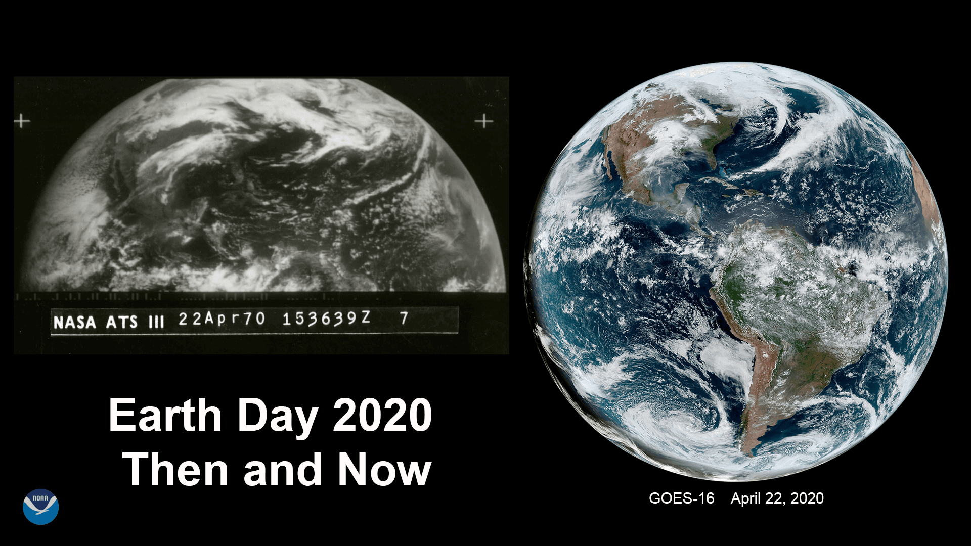
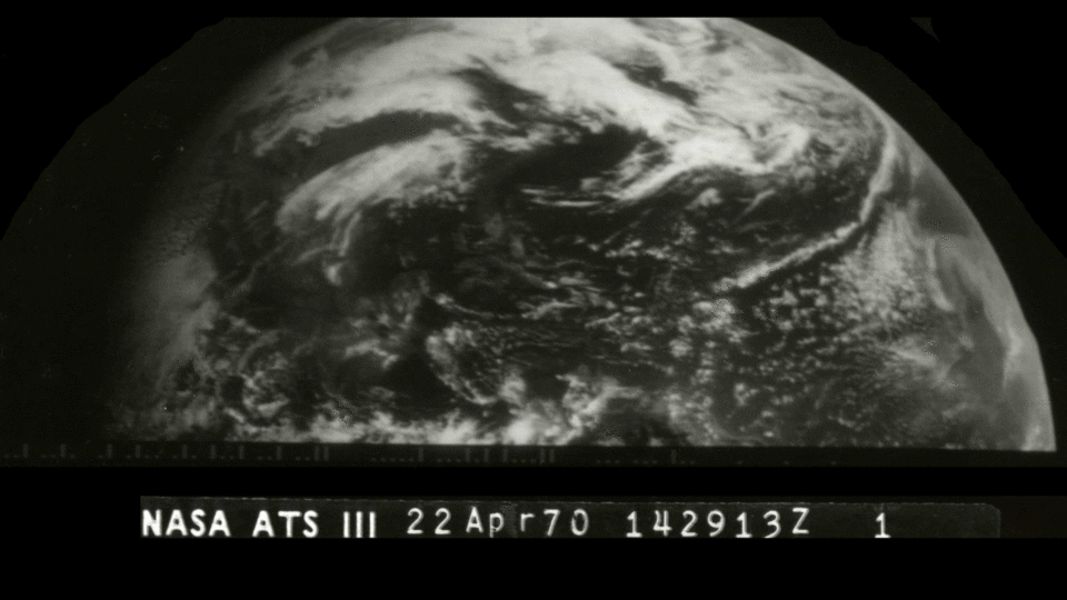 The images above were captured on the very first Earth Day by the spin-scan camera aboard NASA’s Applications Technology Satellite-3 (ATS-3), which provided hemispheric visible images of the sun-lit Earth every half hour. ATS-3, along with its “cloud camera” sensor, was an experimental precursor to the current Geostationary Operational Environmental Satellite (GOES) series.
This geostationary satellite was positioned approximately 22,300 miles above the Earth, which is the same orbit that NOAA’s current GOES series satellites occupy today. The first GOES satellite was launched on Oct. 16, 1975.
The images above were captured on the very first Earth Day by the spin-scan camera aboard NASA’s Applications Technology Satellite-3 (ATS-3), which provided hemispheric visible images of the sun-lit Earth every half hour. ATS-3, along with its “cloud camera” sensor, was an experimental precursor to the current Geostationary Operational Environmental Satellite (GOES) series.
This geostationary satellite was positioned approximately 22,300 miles above the Earth, which is the same orbit that NOAA’s current GOES series satellites occupy today. The first GOES satellite was launched on Oct. 16, 1975.
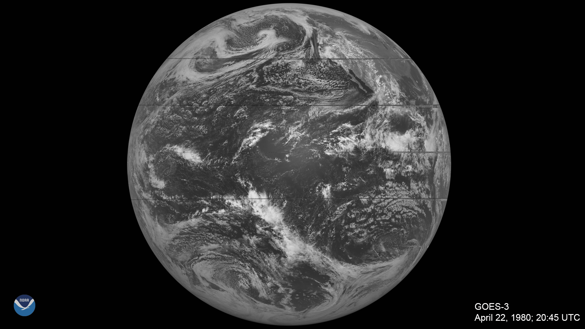 A decade later, NOAA was already on its third GOES spacecraft, which captured this image above on April 22, 1980, the tenth anniversary of Earth Day.
These early GOES satellites only recorded images of the Earth less than 10 percent of the time, as opposed to the constant Earth monitoring our modern satellites provide. Although the early GOES did possess an infrared channel to view clouds at night, they could not provide any indication of cloud thickness, moisture content, or any information pertaining to the various vertical layers of the atmosphere.
A decade later, NOAA was already on its third GOES spacecraft, which captured this image above on April 22, 1980, the tenth anniversary of Earth Day.
These early GOES satellites only recorded images of the Earth less than 10 percent of the time, as opposed to the constant Earth monitoring our modern satellites provide. Although the early GOES did possess an infrared channel to view clouds at night, they could not provide any indication of cloud thickness, moisture content, or any information pertaining to the various vertical layers of the atmosphere.
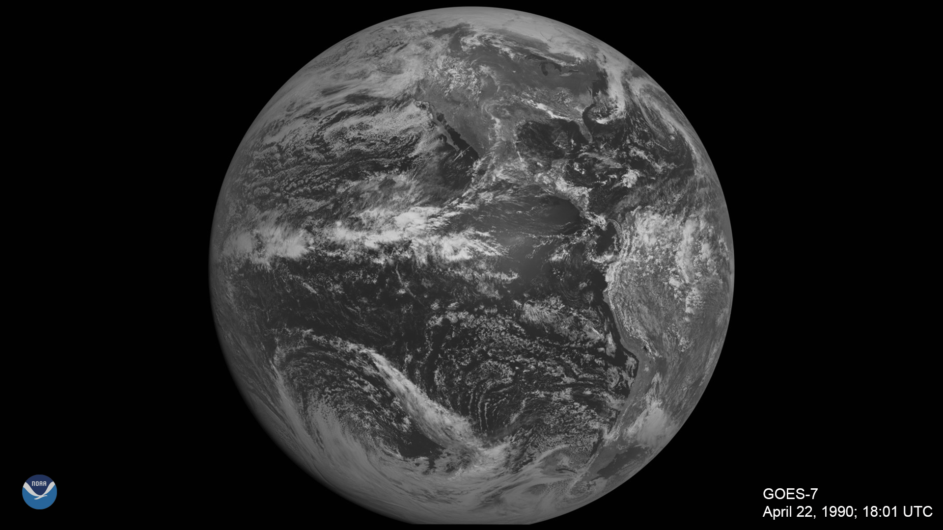 Ten years later, on Earth Day 1990, GOES-7 captured this image of our planet.
It may not look much different from the last image, but the technology aboard this newer satellite was state-of-the-art at the time. While still spin-stabilized, GOES-4 to -7 had the ability to obtain vertical profiles of temperature and moisture throughout the atmosphere, which greatly helped meteorologists to better understand storm systems and make more accurate forecasts.
GOES-7 was also the only satellite in the history of NOAA’s geostationary satellite program to serve as both the GOES-East and GOES-West spacecraft in the course of normal operations after its predecessor, GOES-6, failed. GOES-7 thus served as the sole geostationary spacecraft from 1989 to 1994. During this time, it was moved from the GOES-West position in the winter—where it covered part of the Pacific Ocean and the west coast of North America—to the GOES-East position in the summer and fall—where it watched the East Coast during hurricane season.
Ten years later, on Earth Day 1990, GOES-7 captured this image of our planet.
It may not look much different from the last image, but the technology aboard this newer satellite was state-of-the-art at the time. While still spin-stabilized, GOES-4 to -7 had the ability to obtain vertical profiles of temperature and moisture throughout the atmosphere, which greatly helped meteorologists to better understand storm systems and make more accurate forecasts.
GOES-7 was also the only satellite in the history of NOAA’s geostationary satellite program to serve as both the GOES-East and GOES-West spacecraft in the course of normal operations after its predecessor, GOES-6, failed. GOES-7 thus served as the sole geostationary spacecraft from 1989 to 1994. During this time, it was moved from the GOES-West position in the winter—where it covered part of the Pacific Ocean and the west coast of North America—to the GOES-East position in the summer and fall—where it watched the East Coast during hurricane season.
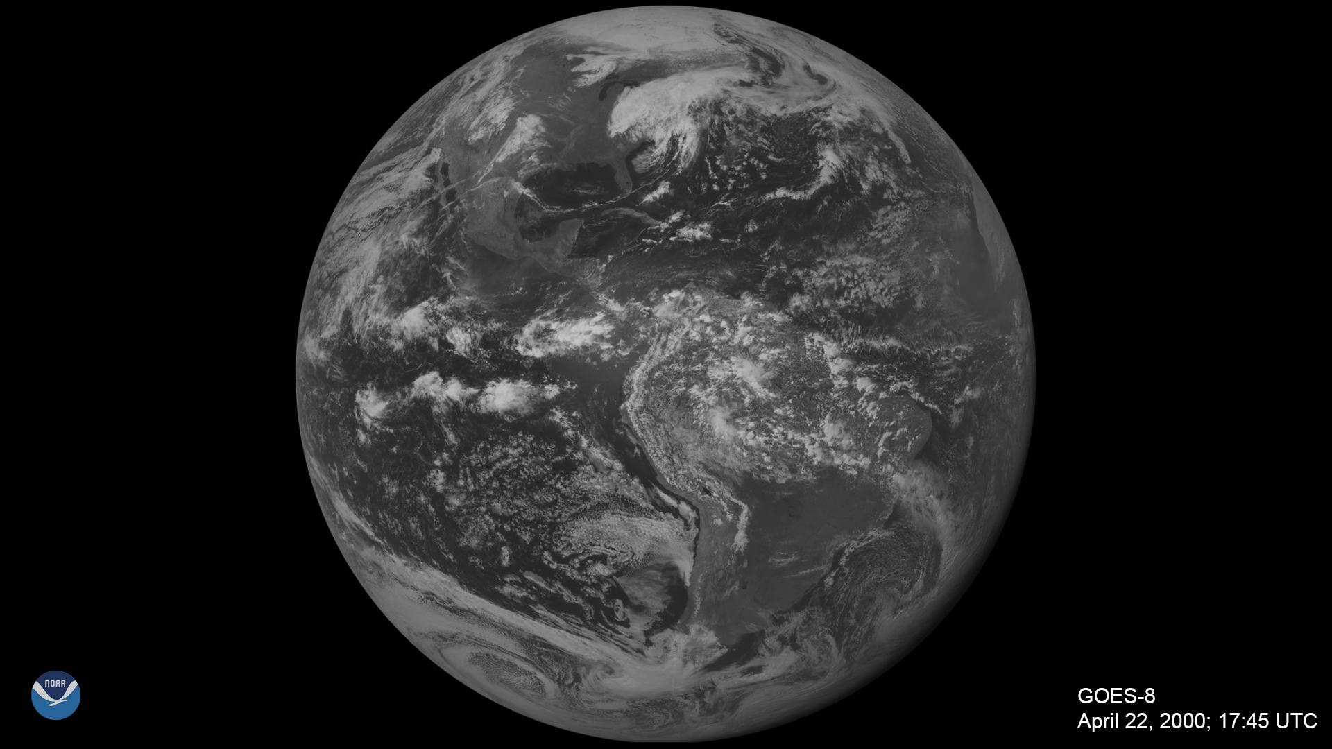 By the thirtieth anniversary of Earth Day in 2000, the GOES-8 satellite brought significant improvements in the resolution, quantity, and continuity of the data it collected thanks to a new three-axis method of stabilization for the spacecraft and separate optics for imaging and sounding. Three-axis stabilization allowed the imager and sounder to work simultaneously, which gave forecasters more accurate information to pinpoint locations of storms and other dangerous weather events. The satellite could also focus in on smaller areas to improve short-term forecasts, and its sensors provided finer spatial resolution imagery to better monitor small-scale features, such as fires.
Fun fact: This satellite was featured in the 1996 film, Twister.
By the thirtieth anniversary of Earth Day in 2000, the GOES-8 satellite brought significant improvements in the resolution, quantity, and continuity of the data it collected thanks to a new three-axis method of stabilization for the spacecraft and separate optics for imaging and sounding. Three-axis stabilization allowed the imager and sounder to work simultaneously, which gave forecasters more accurate information to pinpoint locations of storms and other dangerous weather events. The satellite could also focus in on smaller areas to improve short-term forecasts, and its sensors provided finer spatial resolution imagery to better monitor small-scale features, such as fires.
Fun fact: This satellite was featured in the 1996 film, Twister.
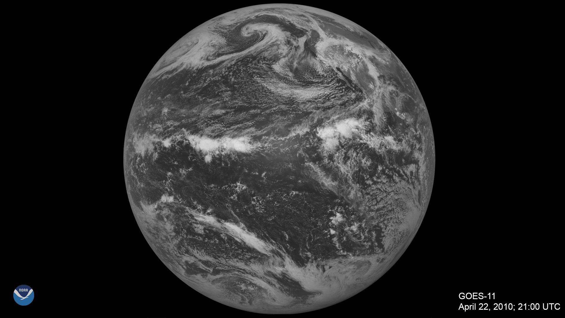
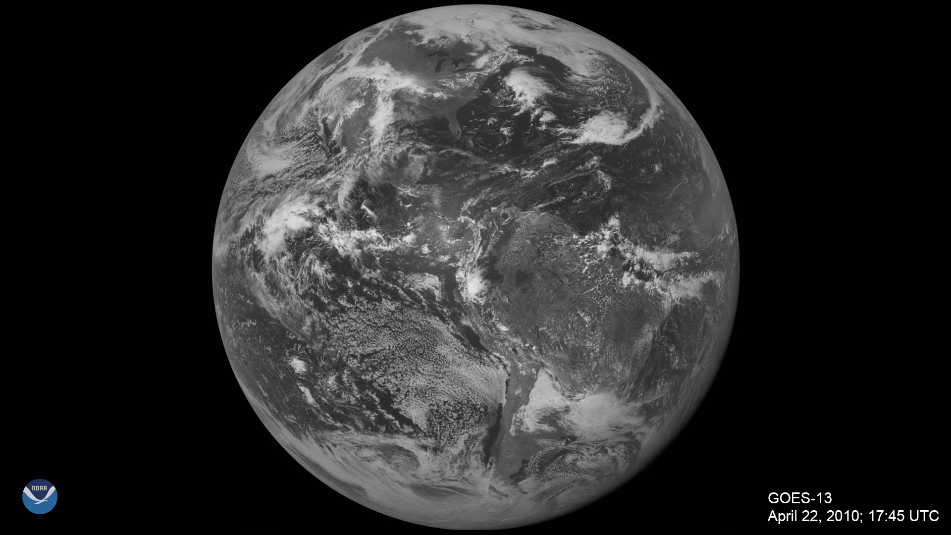 These two views of the Earth were taken by GOES-11 (GOES-West) and GOES-13 (GOES-East) on Earth Day, 2010. GOES-13 through -15 utilized the Image Navigation and Registration subsystem, which helped better pinpoint the locations of storms using geographic landmarks. These satellites also had improved optics, better batteries, and more power, allowing for more continuous imaging. The GOES-8 through -15 series of satellites monitored an array of weather and atmospheric phenomena on Earth, as well as space weather.
Earth Day 2010 actually saw severe weather in the Great Plains, where powerful thunderstorms caused damaging winds, large hail, and 40 tornado reports. You can see this storm system in both images above.
These two views of the Earth were taken by GOES-11 (GOES-West) and GOES-13 (GOES-East) on Earth Day, 2010. GOES-13 through -15 utilized the Image Navigation and Registration subsystem, which helped better pinpoint the locations of storms using geographic landmarks. These satellites also had improved optics, better batteries, and more power, allowing for more continuous imaging. The GOES-8 through -15 series of satellites monitored an array of weather and atmospheric phenomena on Earth, as well as space weather.
Earth Day 2010 actually saw severe weather in the Great Plains, where powerful thunderstorms caused damaging winds, large hail, and 40 tornado reports. You can see this storm system in both images above.
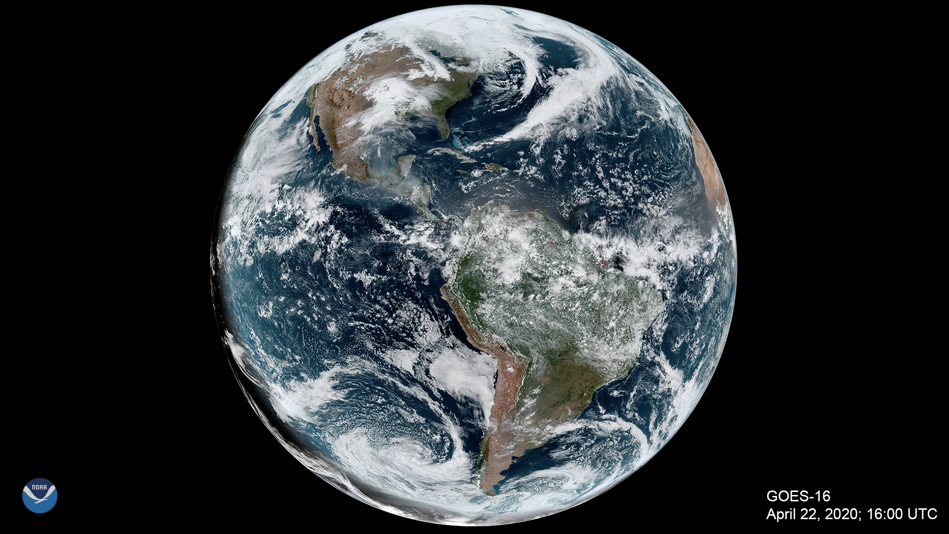 Finally, this image of our beautiful planet was taken by GOES-16, the current GOES-East satellite, on April 22, 2020. Together with its sister satellite, GOES-17 in the GOES-West position, the high-resolution imagery they both gather provides optimal viewing of severe weather events and other atmospheric phenomena from the Pacific Ocean to the western coast of Africa.
The Advanced Baseline Imager (ABI) on the GOES-R series is a major advancement because it can scan both routine “full disk” imagery and more localized areas as often as every 30 seconds to help deliver more accurate short-term weather forecasts. The ABI provides three times more spectral information, four times the spatial resolution, and more than five times faster temporal coverage than the previous system. It views the Earth with 16 different spectral bands (wavelengths) compared to five on the previous generation of GOES, including two visible channels, four near-infrared channels, and ten infrared channels.
Finally, this image of our beautiful planet was taken by GOES-16, the current GOES-East satellite, on April 22, 2020. Together with its sister satellite, GOES-17 in the GOES-West position, the high-resolution imagery they both gather provides optimal viewing of severe weather events and other atmospheric phenomena from the Pacific Ocean to the western coast of Africa.
The Advanced Baseline Imager (ABI) on the GOES-R series is a major advancement because it can scan both routine “full disk” imagery and more localized areas as often as every 30 seconds to help deliver more accurate short-term weather forecasts. The ABI provides three times more spectral information, four times the spatial resolution, and more than five times faster temporal coverage than the previous system. It views the Earth with 16 different spectral bands (wavelengths) compared to five on the previous generation of GOES, including two visible channels, four near-infrared channels, and ten infrared channels.
The images above were captured on the very first Earth Day by the spin-scan camera aboard NASA’s Applications Technology Satellite-3 (ATS-3), which provided hemispheric visible images of the sun-lit Earth every half hour. ATS-3, along with its “cloud camera” sensor, was an experimental precursor to the current Geostationary Operational Environmental Satellite (GOES) series.
This geostationary satellite was positioned approximately 22,300 miles above the Earth, which is the same orbit that NOAA’s current GOES series satellites occupy today. The first GOES satellite was launched on Oct. 16, 1975.
A decade later, NOAA was already on its third GOES spacecraft, which captured this image above on April 22, 1980, the tenth anniversary of Earth Day.
These early GOES satellites only recorded images of the Earth less than 10 percent of the time, as opposed to the constant Earth monitoring our modern satellites provide. Although the early GOES did possess an infrared channel to view clouds at night, they could not provide any indication of cloud thickness, moisture content, or any information pertaining to the various vertical layers of the atmosphere.
Ten years later, on Earth Day 1990, GOES-7 captured this image of our planet.
It may not look much different from the last image, but the technology aboard this newer satellite was state-of-the-art at the time. While still spin-stabilized, GOES-4 to -7 had the ability to obtain vertical profiles of temperature and moisture throughout the atmosphere, which greatly helped meteorologists to better understand storm systems and make more accurate forecasts.
GOES-7 was also the only satellite in the history of NOAA’s geostationary satellite program to serve as both the GOES-East and GOES-West spacecraft in the course of normal operations after its predecessor, GOES-6, failed. GOES-7 thus served as the sole geostationary spacecraft from 1989 to 1994. During this time, it was moved from the GOES-West position in the winter—where it covered part of the Pacific Ocean and the west coast of North America—to the GOES-East position in the summer and fall—where it watched the East Coast during hurricane season.
By the thirtieth anniversary of Earth Day in 2000, the GOES-8 satellite brought significant improvements in the resolution, quantity, and continuity of the data it collected thanks to a new three-axis method of stabilization for the spacecraft and separate optics for imaging and sounding. Three-axis stabilization allowed the imager and sounder to work simultaneously, which gave forecasters more accurate information to pinpoint locations of storms and other dangerous weather events. The satellite could also focus in on smaller areas to improve short-term forecasts, and its sensors provided finer spatial resolution imagery to better monitor small-scale features, such as fires.
Fun fact: This satellite was featured in the 1996 film, Twister.
These two views of the Earth were taken by GOES-11 (GOES-West) and GOES-13 (GOES-East) on Earth Day, 2010. GOES-13 through -15 utilized the Image Navigation and Registration subsystem, which helped better pinpoint the locations of storms using geographic landmarks. These satellites also had improved optics, better batteries, and more power, allowing for more continuous imaging. The GOES-8 through -15 series of satellites monitored an array of weather and atmospheric phenomena on Earth, as well as space weather.
Earth Day 2010 actually saw severe weather in the Great Plains, where powerful thunderstorms caused damaging winds, large hail, and 40 tornado reports. You can see this storm system in both images above.
Finally, this image of our beautiful planet was taken by GOES-16, the current GOES-East satellite, on April 22, 2020. Together with its sister satellite, GOES-17 in the GOES-West position, the high-resolution imagery they both gather provides optimal viewing of severe weather events and other atmospheric phenomena from the Pacific Ocean to the western coast of Africa.
The Advanced Baseline Imager (ABI) on the GOES-R series is a major advancement because it can scan both routine “full disk” imagery and more localized areas as often as every 30 seconds to help deliver more accurate short-term weather forecasts. The ABI provides three times more spectral information, four times the spatial resolution, and more than five times faster temporal coverage than the previous system. It views the Earth with 16 different spectral bands (wavelengths) compared to five on the previous generation of GOES, including two visible channels, four near-infrared channels, and ten infrared channels.
All Weather News
More


More Storms for the East Sunday and Monday
A low-pressure system crashing through the Mi
2 Aug 2026 2:20 AM

After Reaching Category 5, Genevieve Weakens in the Pacific
PacificGenevieve formed on last Friday south
2 Aug 2026 1:30 AM

Flooding, Severe Storms Target the Midwest Again
After an active week of storms across the nor
1 Aug 2026 1:40 AM

Flooding Risk Increases as Heavy Rain Targets the Tri-State Area
Tuesday, heavy rainfall moved across the Nort
30 Jul 2026 12:25 AM

Severe Weather: Energy From the Midwest Now in the Southeast
UPPER MIDWEST - Through Monday, dangerous tor
29 Jul 2026 10:30 PM