A Soggy Summer for the Mid-Atlantic
Special Stories
24 Aug 2018 9:21 AM
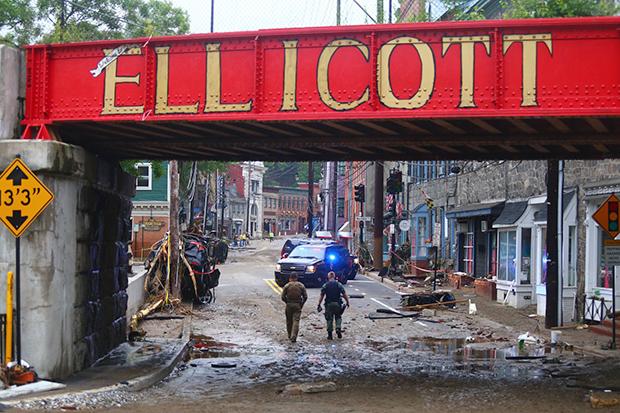
[Mud and flood debris blanketed a section of main street below an overpass in Ellicott City, Maryland, after flash flooding in May. Photo courtesy Howard County government.]
From NOAA by Tom Di Liberto
While the western United States has been dealing with a non-stop onslaught of heat, wildfires, and smoke, the eastern United States has seen its summer dominated by weather forecasts containing the phrase “a chance of showers.”
From May through July 2018, much of the East Coast, especially the Mid-Atlantic, has been observing rain up to 300% of normal. In May, areas from Pennsylvania down to Florida saw rains 100 to 200% of normal. By June and July, the epicenter for heaviest rains became focused over the Mid-Atlantic, as monthly rains near Washington, D.C. through central Pennsylvania easily eclipsed 200% of normal.
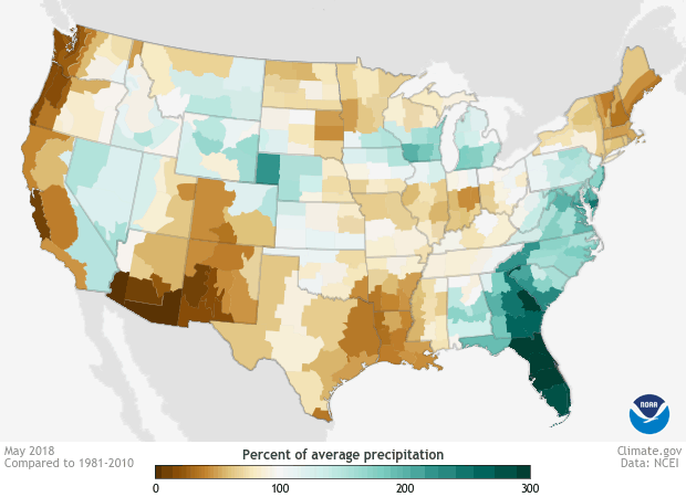 [Percent of average (1981-2010) precipitation in May, June, and July 2018 for each U.S. climate division—brown for less than average, and blue-green for more than average. While the western U.S. generally received below-average precipitation, the East, especially the Mid-Atlantic, was wetter than average. NOAA Climate image using data from the National Centers for Environmental Information.]
To put some actual rainfall numbers out there, from June 1 through August 13, Baltimore, Maryland, observed over 23 inches of rain, a total over 250% more than normal. Washington, D.C., meanwhile, saw rains over 180% of normal at the same time. The rains in Maryland have been so heavy that, statewide, the May-July period was the wettest in state history (124 years), with Julybecoming the second wettest July on record.
Pennsylvania joined in on the record breaking, too. The May-July period for the entire state was the third wettest on record, with July 2018 being the wettest July in the last 124 years. In Williamsport, PA, home to the ongoing Little League World Series, the rainfall tally from June 1 through August 13 was over 21 inches, around 11 inches more than normal. (I’m sure the kids will have no problem playing in any muddy conditions. Their washing machines might not be too happy about it, though.)
[Percent of average (1981-2010) precipitation in May, June, and July 2018 for each U.S. climate division—brown for less than average, and blue-green for more than average. While the western U.S. generally received below-average precipitation, the East, especially the Mid-Atlantic, was wetter than average. NOAA Climate image using data from the National Centers for Environmental Information.]
To put some actual rainfall numbers out there, from June 1 through August 13, Baltimore, Maryland, observed over 23 inches of rain, a total over 250% more than normal. Washington, D.C., meanwhile, saw rains over 180% of normal at the same time. The rains in Maryland have been so heavy that, statewide, the May-July period was the wettest in state history (124 years), with Julybecoming the second wettest July on record.
Pennsylvania joined in on the record breaking, too. The May-July period for the entire state was the third wettest on record, with July 2018 being the wettest July in the last 124 years. In Williamsport, PA, home to the ongoing Little League World Series, the rainfall tally from June 1 through August 13 was over 21 inches, around 11 inches more than normal. (I’m sure the kids will have no problem playing in any muddy conditions. Their washing machines might not be too happy about it, though.)
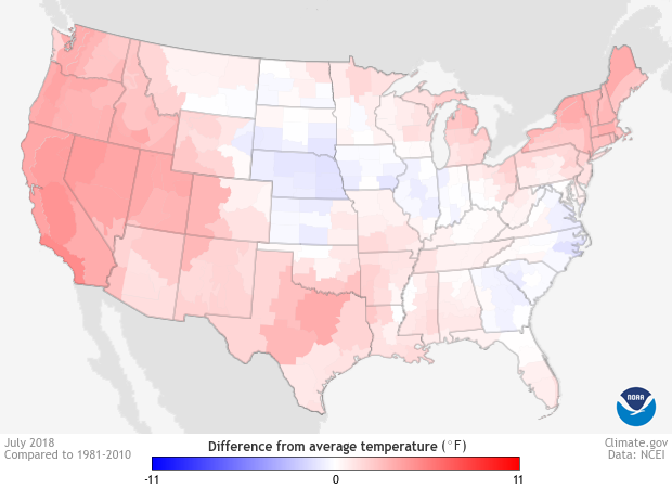 [Temperatures for the contiguous United States during July 2018 compared to the 1981-2010 average—blue for cooler than average, red for warmer than average. Despite the soggy conditions, many states in the East experienced a warmer than average July. NOAA Climate image using data from the National Centers for Environmental Information.]
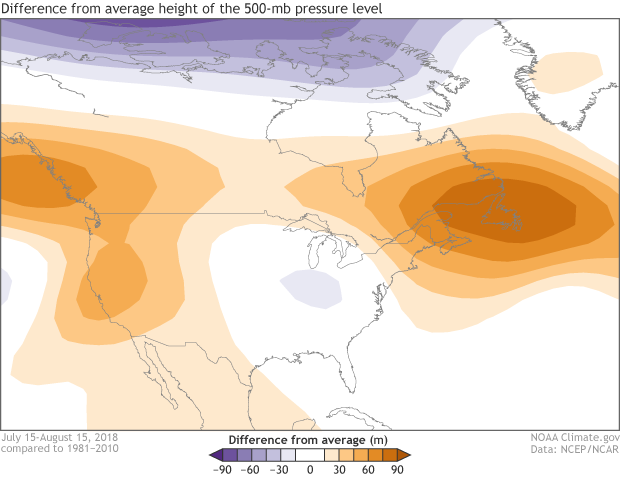 [Atmospheric pressure patterns over the United States for July 15-August 15, 2018, compared to the long-term average (1981–2010). Positive height anomalies (oranges) indicate high pressure and dry conditions, while negative height anomalies (purples) indicate low pressure, which typically goes hand in hand with wet, stormy conditions. The eastern U.S. was located under low pressure for much of the period, giving rise to extremely wet weather in places. NOAA Climate map, based on NCEP/NCAR Reanalysis data.]
[Percent of average (1981-2010) precipitation in May, June, and July 2018 for each U.S. climate division—brown for less than average, and blue-green for more than average. While the western U.S. generally received below-average precipitation, the East, especially the Mid-Atlantic, was wetter than average. NOAA Climate image using data from the National Centers for Environmental Information.]
To put some actual rainfall numbers out there, from June 1 through August 13, Baltimore, Maryland, observed over 23 inches of rain, a total over 250% more than normal. Washington, D.C., meanwhile, saw rains over 180% of normal at the same time. The rains in Maryland have been so heavy that, statewide, the May-July period was the wettest in state history (124 years), with Julybecoming the second wettest July on record.
Pennsylvania joined in on the record breaking, too. The May-July period for the entire state was the third wettest on record, with July 2018 being the wettest July in the last 124 years. In Williamsport, PA, home to the ongoing Little League World Series, the rainfall tally from June 1 through August 13 was over 21 inches, around 11 inches more than normal. (I’m sure the kids will have no problem playing in any muddy conditions. Their washing machines might not be too happy about it, though.)
[Temperatures for the contiguous United States during July 2018 compared to the 1981-2010 average—blue for cooler than average, red for warmer than average. Despite the soggy conditions, many states in the East experienced a warmer than average July. NOAA Climate image using data from the National Centers for Environmental Information.]
Well, at least the temperatures were probably cooler than average then?
You’d think, at least. Normally if a three-month or one-month period is wetter than average, temperatures tend to be a bit cooler than average. Why? One simple reason is that more rain usually means more clouds, which keep daytime temperatures down. But things didn’t exactly follow that pattern in 2018. May through July were near or record-warm for much of the country. And many states across the eastern United States observed average temperatures that were easily in the top 10 warmest since 1895. Even in July, when rains were incredibly heavy in the Mid-Atlantic, average temperatures were near to above-average. Pennsylvania, for instance, had its wettest July on record and its average temperature in July remained in the top 30 of all years back to 1895.
[Atmospheric pressure patterns over the United States for July 15-August 15, 2018, compared to the long-term average (1981–2010). Positive height anomalies (oranges) indicate high pressure and dry conditions, while negative height anomalies (purples) indicate low pressure, which typically goes hand in hand with wet, stormy conditions. The eastern U.S. was located under low pressure for much of the period, giving rise to extremely wet weather in places. NOAA Climate map, based on NCEP/NCAR Reanalysis data.]
What’s going on?
One incredibly stubborn and persistent weather pattern, that’s what. And it’s the same pattern that has led to the hot and dry conditions out west. Basically, the eastern United States has been stuck in a trough of low atmospheric pressure, or a place conducive for the development of rain storms, while to the west and northeast have been ridges of high atmosphere pressure. These high pressures have not only helped caused sunny skies and hotter temperatures, but they have also served as giant mountains in the atmospheric “landscape.” These atmospheric mountains have made it difficult for storms to move out quickly. And when weather lingers, extremes happen. Edited for WeatherNation by Meteorologist Mace MichaelsAll Weather News
More
More Storms for the East Through Monday
A low-pressure system that moved through the
2 Aug 2026 10:40 PM

Wildfire Outbreak in the Pacific Northwest
SPOKANE, WA - On Saturday, August 1st, the Ol
2 Aug 2026 10:35 PM


After Reaching Category 5, Genevieve Weakens in the Pacific
PacificGenevieve formed on last Friday south
2 Aug 2026 6:25 PM

Flooding, Severe Storms Target the Midwest Again
After an active week of storms across the nor
1 Aug 2026 1:40 AM

Flooding Risk Increases as Heavy Rain Targets the Tri-State Area
Tuesday, heavy rainfall moved across the Nort
30 Jul 2026 12:25 AM

Severe Weather: Energy From the Midwest Now in the Southeast
UPPER MIDWEST - Through Monday, dangerous tor
29 Jul 2026 10:30 PM