Another Hot Day in the High Plains
Special Stories
12 Aug 2018 11:06 AM
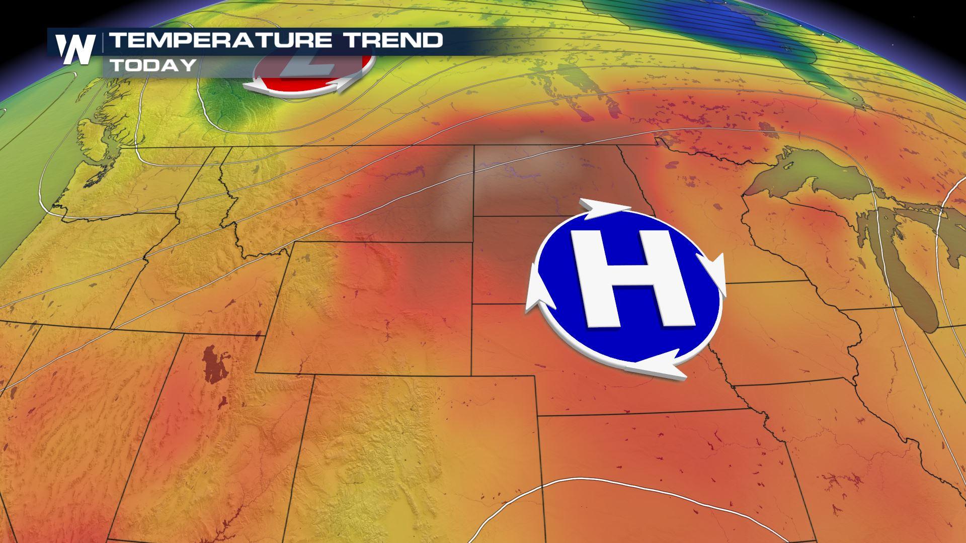
Due to high pressure sitting over the high plains, we are expecting another hot day!
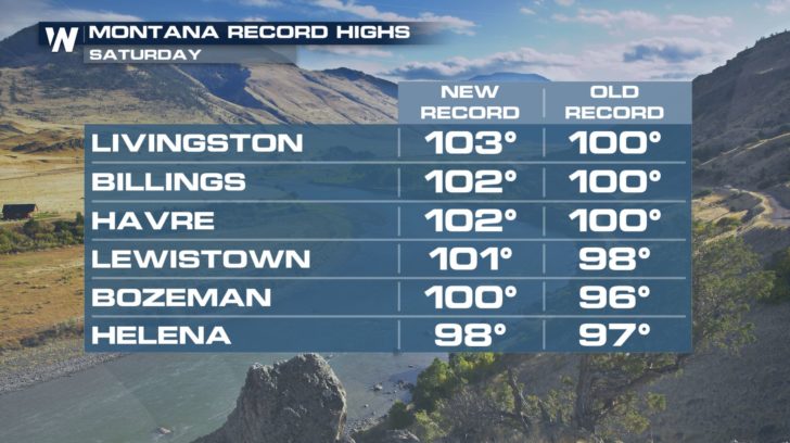
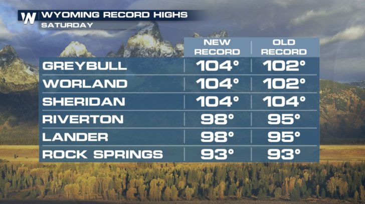 Many areas in Wyoming and Montana already reached record high temperatures yesterday. Most cities saw temperatures in the upper 90s and lower 100s.
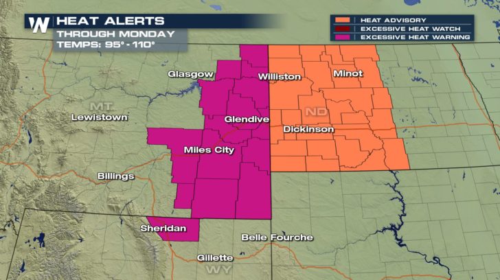 Multiple heat advisories and excessive heat warnings are in effect through Monday morning.
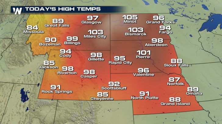 Expect temperatures to reach anywhere from 95 degrees to 110 degrees, today. Areas in North Dakota could reach record temperatures. Make sure to stay hydrated throughout the day, and stay indoors as much as possible.
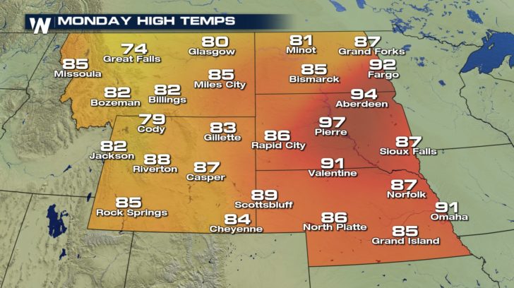 Relief is on the way, though! Temperatures cool down exponentially for our Monday afternoon! We will be back into the 80s for most areas as the high pressure shifts east.
For WeatherNation -Meteorologist Shelly Lindblade
Relief is on the way, though! Temperatures cool down exponentially for our Monday afternoon! We will be back into the 80s for most areas as the high pressure shifts east.
For WeatherNation -Meteorologist Shelly Lindblade
Many areas in Wyoming and Montana already reached record high temperatures yesterday. Most cities saw temperatures in the upper 90s and lower 100s.
Multiple heat advisories and excessive heat warnings are in effect through Monday morning.
Expect temperatures to reach anywhere from 95 degrees to 110 degrees, today. Areas in North Dakota could reach record temperatures. Make sure to stay hydrated throughout the day, and stay indoors as much as possible.
Relief is on the way, though! Temperatures cool down exponentially for our Monday afternoon! We will be back into the 80s for most areas as the high pressure shifts east.
For WeatherNation -Meteorologist Shelly Lindblade
All Weather News
More
More Storms for the East Through Monday
A low-pressure system that moved through the
2 Aug 2026 10:40 PM

Wildfire Outbreak in the Pacific Northwest
SPOKANE, WA - On Saturday, August 1st, the Ol
2 Aug 2026 10:35 PM


After Reaching Category 5, Genevieve Weakens in the Pacific
PacificGenevieve formed on last Friday south
2 Aug 2026 6:25 PM

Flooding, Severe Storms Target the Midwest Again
After an active week of storms across the nor
1 Aug 2026 1:40 AM

Flooding Risk Increases as Heavy Rain Targets the Tri-State Area
Tuesday, heavy rainfall moved across the Nort
30 Jul 2026 12:25 AM

Severe Weather: Energy From the Midwest Now in the Southeast
UPPER MIDWEST - Through Monday, dangerous tor
29 Jul 2026 10:30 PM